
קובץ:South Africa racial map, 1979.gif

גודל התצוגה המקדימה הזאת: 767 × 600 פיקסלים. רזולוציות אחרות: 307 × 240 פיקסלים | 614 × 480 פיקסלים | 940 × 735 פיקסלים.
לקובץ המקורי (940 × 735 פיקסלים, גודל הקובץ: 249 ק"ב, סוג MIME: image/gif)
| זהו קובץ שמקורו במיזם ויקישיתוף. תיאורו בדף תיאור הקובץ המקורי (בעברית) מוצג למטה. |
תקציר

|
יש ליצור מחדש את התמונה ethnographic map הזו באמצעות גרפיקה וקטורית כדוגמת קובץ SVG. לפעולה זו מספר יתרונות, כפי שניתן לקרוא (באנגלית) בדף Commons:Media for cleanup. אם ברשותכם קובץ SVG, אנא העלו אותו. לאחר מכן, החליפו תבנית זו בתבנית
{{vector version available|שם הקובץ.svg}} |
| תיאור |
Afrikaans: Rassedemografie van Suid-Afrika volgens 1970-sensusdata
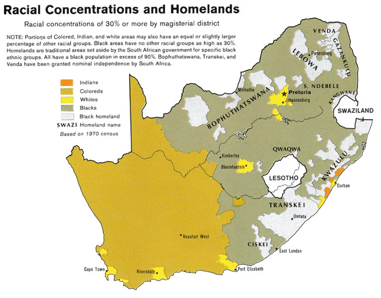
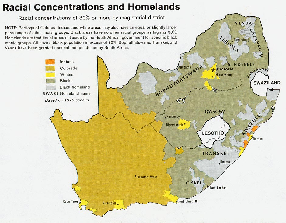
English: Map showing the territorial four main races/ethnicities/colors of South Africa in 1979: Whites, Coloureds, Blacks and Indians. The gray areas indicate the Apartheid-era Bantustans, which are almost exclusively black.
This map is a photoshopped version of the CIA-made original map at Perry Castañeda map collection at the University of Texas website. |
| תאריך יצירה | |
| מקור |
הועבר מ- en.wikipedia לוויקישיתוףעל ידי Magnus Manske באמצעות CommonsHelper. (Original text : * Site: Perry-Castañeda Library Map Collection: South Africa Maps |
| יוצר | U.S. Central Intelligence Agency |
| אישורים והיתרים (שימוש חוזר בקובץ זה) |
Public domain |
| גרסאות אחרות |
 |
רישיון
| This image is a work of a Central Intelligence Agency employee, taken or made as part of that person's official duties. As a Work of the United States Government, this image or media is in the public domain in the United States.
|

|
יומן העלאה מקורי
תיאור הקובץ המקורי נמצא כאן. כל שמות המשתמשים הבאים מתייחסים ל-en.wikipedia.
- 2008-08-23 06:02 MaGioZal 940×735× (254595 bytes) Map showing the territorial four main races/ethnicities/colors of South Africa in 1979: [[South African Whites|Whites]], [[Colored (South Africa)|Coloreds]], [[South African Blacks|Blacks]] and [[South African Indians|Indians]]. The gray areas indicate th
היסטוריית הקובץ
ניתן ללחוץ על תאריך/שעה כדי לראות את הקובץ כפי שנראה באותו זמן.
| תאריך/שעה | תמונה ממוזערת | ממדים | משתמש | הערה | |
|---|---|---|---|---|---|
| נוכחית | 23:50, 19 בפברואר 2011 | | 735 × 940 (249 ק"ב) | File Upload Bot (Magnus Manske) | {{BotMoveToCommons|en.wikipedia|year={{subst:CURRENTYEAR}}|month={{subst:CURRENTMONTHNAME}}|day={{subst:CURRENTDAY}}}} {{Information |Description={{en|Map showing the territorial four main races/ethnicities/colors of South Africa in 1979: [[:en:Whites in |
שימוש בקובץ
הדף הבא משתמש בקובץ הזה:
שימוש גלובלי בקובץ
אתרי הוויקי השונים הבאים משתמשים בקובץ זה:
- שימוש באתר af.wikipedia.org
- שימוש באתר ast.wikipedia.org
- שימוש באתר ca.wikipedia.org
- שימוש באתר cs.wikipedia.org
- שימוש באתר en.wikipedia.org
- שימוש באתר es.wikipedia.org
- שימוש באתר fa.wikipedia.org
- שימוש באתר krc.wikipedia.org
- שימוש באתר pnb.wikipedia.org
- שימוש באתר pt.wikipedia.org
- שימוש באתר sh.wikipedia.org
- שימוש באתר sl.wikipedia.org
- שימוש באתר sr.wikipedia.org
- שימוש באתר ta.wikipedia.org
- שימוש באתר uk.wikipedia.org
- שימוש באתר zh.wikipedia.org