
קובץ:TVA-sites-map.png
אין גרסה ברזולוציה גבוהה יותר.
TVA-sites-map.png (439 × 325 פיקסלים, גודל הקובץ: 20 ק"ב, סוג MIME: image/png)
| זהו קובץ שמקורו במיזם ויקישיתוף. תיאורו בדף תיאור הקובץ המקורי (בעברית) מוצג למטה. |
תקציר
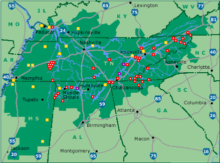
| תיאור | Map of Tennessee Valley Authority sites. Key: red: dam, magenta: nuclear power plant, orange: fossil-fuel plant |
| מקור | tva.com |
| יוצר | Tennessee Valley Authority |
רישיון
| This image is a work of a United States Tennessee Valley Authority employee, taken or made as part of that person's official duties. As a work of the U.S. federal government, the image is in the public domain in the United States. |
יומן העלאה מקורי
(All user names refer to en.wikipedia)
- 2005-05-18 01:09 ChrisRuvolo 439×325×8 (19706 bytes) Map of [[Tennessee Valley Authority]] sites. Key: red: [[dam]], magenta: [[nuclear power plant]] orange: [[fossil fuel]] plant Source: [http://www.tva.gov/sites/sites_ie2.htm] [http://www.tva.gov/sites/images/sitesmap3.gif], converted to PNG {{PD-USG
היסטוריית הקובץ
ניתן ללחוץ על תאריך/שעה כדי לראות את הקובץ כפי שנראה באותו זמן.
| תאריך/שעה | תמונה ממוזערת | ממדים | משתמש | הערה | |
|---|---|---|---|---|---|
| נוכחית | 13:03, 9 באוגוסט 2015 | | 325 × 439 (20 ק"ב) | Kopiersperre | png repaired |
| 14:49, 26 במאי 2007 |  | 325 × 439 (19 ק"ב) | Kordas | {{Information |Description=Map of en:Tennessee Valley Authority sites. Key: red: en:dam, magenta: en:nuclear power plant orange: en:fossil fuel plant Source: [http://www.tva.gov/sites/sites_ie2.htm] [http://www.tva.gov/sites/images |
שימוש בקובץ
הדף הבא משתמש בקובץ הזה:
שימוש גלובלי בקובץ
אתרי הוויקי השונים הבאים משתמשים בקובץ זה:
- שימוש באתר da.wikipedia.org
- שימוש באתר es.wikipedia.org
- שימוש באתר nl.wikipedia.org
- שימוש באתר no.wikipedia.org
- שימוש באתר zh.wikipedia.org