
קובץ:USA Territorial Growth 1820 alt.jpg

גודל התצוגה המקדימה הזאת: 800 × 369 פיקסלים. רזולוציות אחרות: 320 × 148 פיקסלים | 640 × 295 פיקסלים | 1,192 × 550 פיקסלים.
לקובץ המקורי (1,192 × 550 פיקסלים, גודל הקובץ: 131 ק"ב, סוג MIME: image/jpeg)
| זהו קובץ שמקורו במיזם ויקישיתוף. תיאורו בדף תיאור הקובץ המקורי (בעברית) מוצג למטה. |
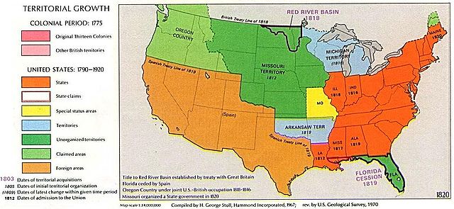
1970 USGS map
This image is in the public domain in the United States because it only contains materials that originally came from the United States Geological Survey, an agency of the United States Department of the Interior. For more information, see the official USGS copyright policy.
|
Other versions: 
Visually reorganized by Beyond My Ken (talk) 22:01, 18 April 2010 (UTC)
| US growth maps |
| Animated: large · small |
| Years |
| 1775 · 1790 · 1800 · 1810 · 1820 · 1830 · 1840 · 1850 · 1860 · 1870 · 1880 · 1900 · 1920 |

|
יש ליצור מחדש את התמונה historical map הזו באמצעות גרפיקה וקטורית כדוגמת קובץ SVG. לפעולה זו מספר יתרונות, כפי שניתן לקרוא (באנגלית) בדף Commons:Media for cleanup. אם ברשותכם קובץ SVG, אנא העלו אותו. לאחר מכן, החליפו תבנית זו בתבנית
{{vector version available|שם הקובץ.svg}} |


היסטוריית הקובץ
ניתן ללחוץ על תאריך/שעה כדי לראות את הקובץ כפי שנראה באותו זמן.
| תאריך/שעה | תמונה ממוזערת | ממדים | משתמש | הערה | |
|---|---|---|---|---|---|
| נוכחית | 01:02, 19 באפריל 2010 | | 550 × 1,192 (131 ק"ב) | Beyond My Ken | First upload failed |
| 01:01, 19 באפריל 2010 |  | 550 × 1,192 (131 ק"ב) | Beyond My Ken | 1970 USGS map {{PD-USGov-USGS}} Other versions: 150px Visually reorganized by ~~~~ {{US growth maps}} {{svg|map}} Category:Territorial Growth Maps of the United States |
שימוש בקובץ
הדף הבא משתמש בקובץ הזה:
שימוש גלובלי בקובץ
אתרי הוויקי השונים הבאים משתמשים בקובץ זה:
- שימוש באתר ang.wikipedia.org
- שימוש באתר ar.wikipedia.org
- שימוש באתר da.wikipedia.org
- שימוש באתר en.wikipedia.org
- שימוש באתר es.wikipedia.org
- שימוש באתר eu.wikipedia.org
- שימוש באתר fr.wikipedia.org
- שימוש באתר id.wikipedia.org
- שימוש באתר it.wikipedia.org
- שימוש באתר ko.wikipedia.org
- שימוש באתר ms.wikipedia.org
- שימוש באתר no.wikipedia.org
- שימוש באתר sv.wikipedia.org
- שימוש באתר zh.wikipedia.org