
קובץ:US wind power map.png
גודל התצוגה המקדימה הזאת: 800 × 505 פיקסלים. רזולוציות אחרות: 320 × 202 פיקסלים | 640 × 404 פיקסלים | 1,130 × 713 פיקסלים.
לקובץ המקורי (1,130 × 713 פיקסלים, גודל הקובץ: 163 ק"ב, סוג MIME: image/png)
| זהו קובץ שמקורו במיזם ויקישיתוף. תיאורו בדף תיאור הקובץ המקורי (בעברית) מוצג למטה. |
תקציר
| תיאור |
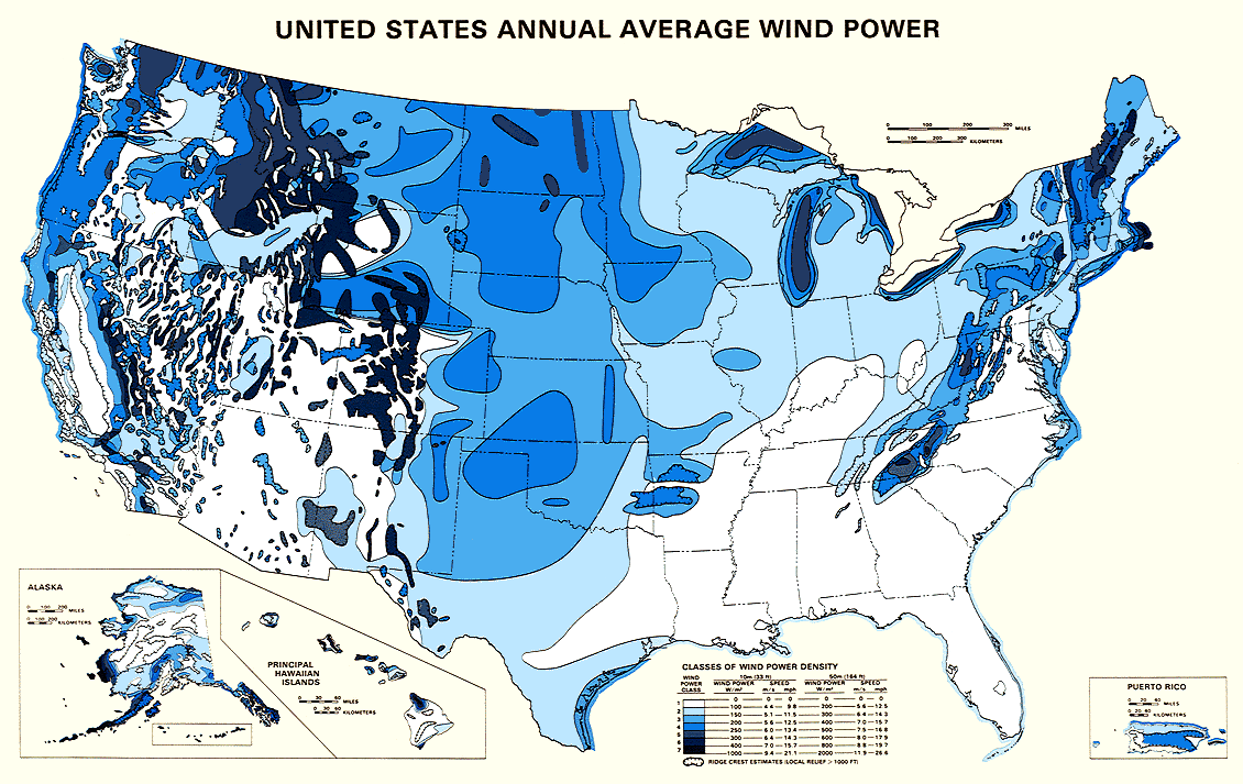
English: Map showing estimated wind resources for the United States. |
| תאריך יצירה | |
| מקור | http://rredc.nrel.gov/wind/pubs/atlas/maps/chap2/2-01m.html |
| יוצר | National Renewable Energy Laboratory |
| אישורים והיתרים (שימוש חוזר בקובץ זה) |
EERE copyright policy says its works are public domain: http://www1.eere.energy.gov/webpolicies/#copyright |
| גרסאות אחרות | an updated version of this map, also showing transmission lines, is in: File:United States Wind Resources and Transmission Lines map.jpg |
- 'Source: English Wikipedia, original upload 5 November 2004 by Iain.mcclatchie en:Image:US wind power map.png
רישיון
| This image is a work of a United States Department of Energy (or predecessor organization) employee, taken or made as part of that person's official duties. As a work of the U.S. federal government, the image is in the public domain.
Please note that national laboratories operate under varying licences and some are not free. Check the site policies of any national lab before crediting it with this tag.
|

|
היסטוריית הקובץ
ניתן ללחוץ על תאריך/שעה כדי לראות את הקובץ כפי שנראה באותו זמן.
| תאריך/שעה | תמונה ממוזערת | ממדים | משתמש | הערה | |
|---|---|---|---|---|---|
| נוכחית | 21:12, 4 בדצמבר 2005 | | 713 × 1,130 (163 ק"ב) | Saperaud~commonswiki | *'''Description:''' U.S. wind power map. Source: United States National Renewable Energy Laboratory [http://rredc.nrel.gov/wind/pubs/atlas/maps/chap2/2-01m.html] *''''Source:''' English Wikipedia, original upload 5 November 2004 by [[:en:User:Iain.mcclat |
שימוש בקובץ
הדף הבא משתמש בקובץ הזה:
שימוש גלובלי בקובץ
אתרי הוויקי השונים הבאים משתמשים בקובץ זה:
- שימוש באתר fa.wikipedia.org
- שימוש באתר fr.wikipedia.org
- שימוש באתר fr.wikibooks.org
- שימוש באתר ht.wikipedia.org
- שימוש באתר ja.wikipedia.org
- שימוש באתר ru.wikipedia.org