קובץ:Umpqua Vicinity Map.jpg
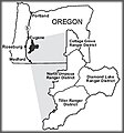
Umpqua_Vicinity_Map.jpg (270 × 290 פיקסלים, גודל הקובץ: 15 ק"ב, סוג MIME: image/jpeg)
היסטוריית הקובץ
ניתן ללחוץ על תאריך/שעה כדי לראות את הקובץ כפי שנראה באותו זמן.
| תאריך/שעה | תמונה ממוזערת | ממדים | משתמש | הערה | |
|---|---|---|---|---|---|
| נוכחית | 13:47, 20 במרץ 2009 |  | 290 × 270 (15 ק"ב) | Urdangaray | {{Information |Description={{en|Vicinity map of the Umpqua National Forest, from the US Forest Service website. http://www.fs.fed.us/r6/umpqua/about/}} |Source=Transferred from [http://en.wikipedia.org en.wikipedia] |Date=2007-12-13 (original upload date |
שימוש בקובץ
הדף הבא משתמש בקובץ הזה:
שימוש גלובלי בקובץ
אתרי הוויקי השונים הבאים משתמשים בקובץ זה:
- שימוש באתר en.wikipedia.org
- שימוש באתר es.wikipedia.org
- שימוש באתר zh.wikipedia.org


