
קובץ:Un-kashmir-jammu.png
לקובץ המקורי (2,302 × 2,901 פיקסלים, גודל הקובץ: 1.1 מ"ב, סוג MIME: image/png)
| זהו קובץ שמקורו במיזם ויקישיתוף. תיאורו בדף תיאור הקובץ המקורי (בעברית) מוצג למטה. |
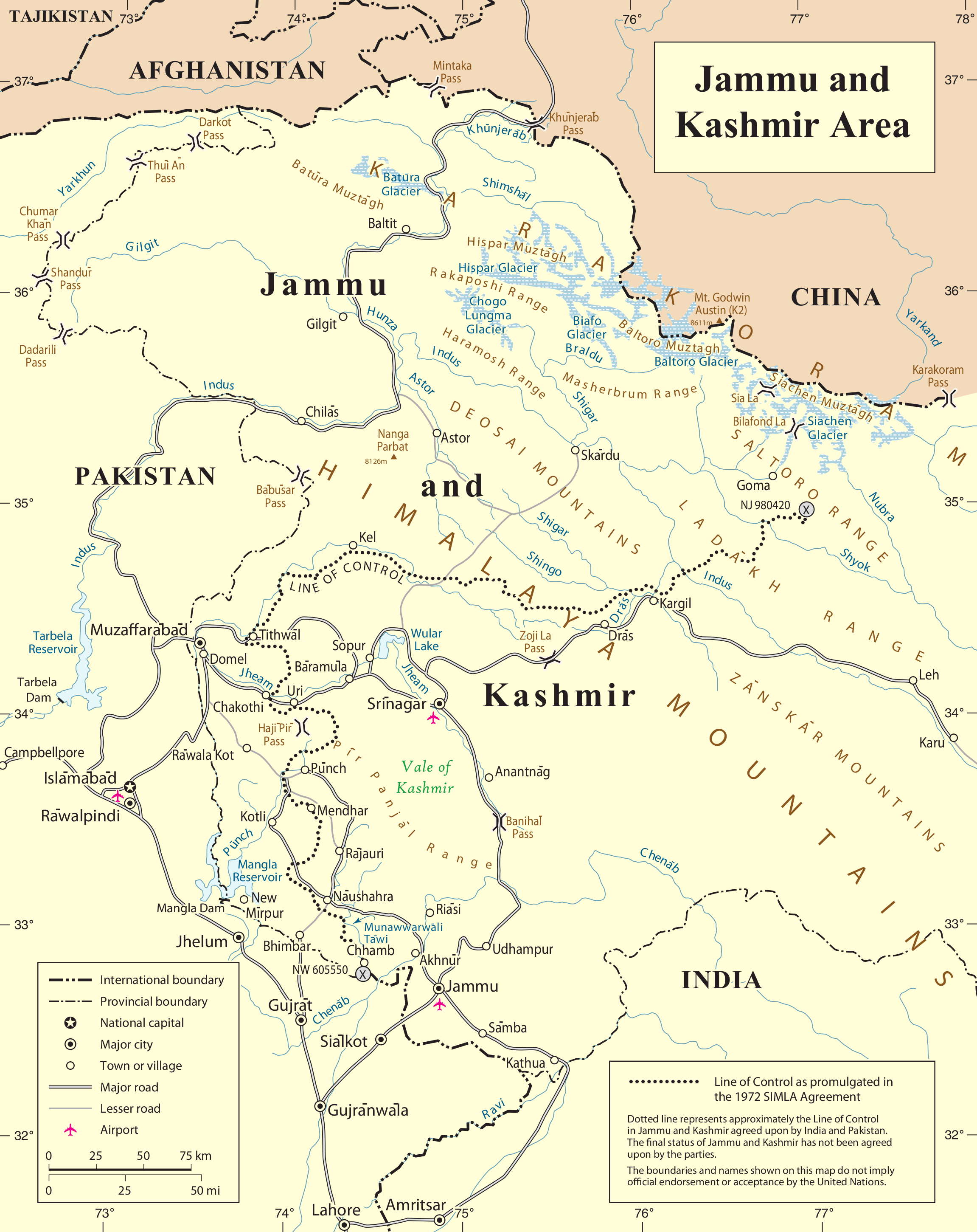
| This image is a map derived from a United Nations map.
Unless stated otherwise, UN maps are to be considered in the public domain. This applies worldwide. UN maps are, in principle, open source material and you can use them in your work or for making your own map. UN requests however that you delete the UN name, logo and reference number upon any modification to the map. Content of your map will be your responsibility. You can state in your publication, if you wish, something like: based on UN map … (map name, map number, revision number and date). See: Geospatial Information Section. And: Geospatial, location data for a better world. |
 |
היסטוריית הקובץ
ניתן ללחוץ על תאריך/שעה כדי לראות את הקובץ כפי שנראה באותו זמן.
| תאריך/שעה | תמונה ממוזערת | ממדים | משתמש | הערה | |
|---|---|---|---|---|---|
| נוכחית | 02:04, 7 ביוני 2010 | | 2,901 × 2,302 (1.1 מ"ב) | Ras67 | cropped |
| 02:28, 22 באוקטובר 2007 |  | 2,947 × 2,348 (1.47 מ"ב) | Jeroen | {{UN map}} Category:Maps of Kashmir |
שימוש בקובץ
הדפים הבאים משתמשים בקובץ הזה:
שימוש גלובלי בקובץ
אתרי הוויקי השונים הבאים משתמשים בקובץ זה:
- שימוש באתר ar.wikipedia.org
- שימוש באתר arz.wikipedia.org
- שימוש באתר azb.wikipedia.org
- שימוש באתר be-tarask.wikipedia.org
- שימוש באתר be.wikipedia.org
- שימוש באתר bn.wikipedia.org
- שימוש באתר ca.wikipedia.org
- שימוש באתר ceb.wikipedia.org
- שימוש באתר en.wikipedia.org
- Hunza (princely state)
- Line of Control
- Indo-Pakistani war of 1947–1948
- Siachen Glacier
- Yarkand River
- Kashmir conflict
- Saltoro Mountains
- Ghent Kangri
- Nowshera, Jammu and Kashmir
- Siachen conflict
- Bilafond La
- Sia La
- Gyong La
- Siachen Base Camp (India)
- Actual Ground Position Line
- Wikipedia:Graphics Lab/Map workshop/Archive/Aug 2011
- Chumik Glacier
- Saltoro Valley
- User:Falcaorib
- User:Johnleeds1/Kashmir conflict
- שימוש באתר es.wikipedia.org
- שימוש באתר fa.wikipedia.org
- שימוש באתר fr.wikipedia.org
- שימוש באתר hi.wikipedia.org