
קובץ:Vancouver1798map-SanJuan-Gulf.png
גודל התצוגה המקדימה הזאת: 521 × 599 פיקסלים. רזולוציות אחרות: 209 × 240 פיקסלים | 417 × 480 פיקסלים | 766 × 881 פיקסלים.
לקובץ המקורי (766 × 881 פיקסלים, גודל הקובץ: 1.39 מ"ב, סוג MIME: image/png)
| זהו קובץ שמקורו במיזם ויקישיתוף. תיאורו בדף תיאור הקובץ המקורי (בעברית) מוצג למטה. |
תקציר
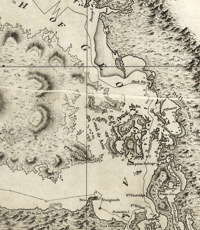
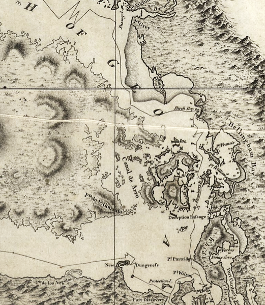
| תיאור | Excerpt of a map by George Vancouver, titled "A chart shewing part of the coast of N.W. America : with the tracks of His Majesty's sloop Discovery and armed tender Chatham / commanded by George Vancouver, Esqr. and prepared under his immediate inspection by Lieut. Joseph Baker..."; published 1798 |
| תאריך יצירה | |
| מקור | http://hdl.loc.gov/loc.gmd/g3512c.ct000914 |
| יוצר | George Vancouver; digital version, Library of Congress, Geography and Map Division. |
| אישורים והיתרים (שימוש חוזר בקובץ זה) |
"The Library of Congress is providing access to these materials for educational and research purposes and is not aware of any U.S. copyright protection" (source: [1]) |
רישיון
This work is in the public domain in the United States because it is a work prepared by an officer or employee of the United States Government as part of that person’s official duties under the terms of Title 17, Chapter 1, Section 105 of the US Code.
Note: This only applies to original works of the Federal Government and not to the work of any individual U.S. state, territory, commonwealth, county, municipality, or any other subdivision. This template also does not apply to postage stamp designs published by the United States Postal Service since 1978. (See § 313.6(C)(1) of Compendium of U.S. Copyright Office Practices). It also does not apply to certain US coins; see The US Mint Terms of Use.
|
 | |
| הקובץ הזה זוהה כקובץ חופשי מכל מגבלה ידועה תחת חוק זכויות היוצרים, כולל כל הזכויות הקשורות והסמוכות. | ||

|
map זה זמין במחלקת {{{division_name}}} תחת מספר מזהה: ct000914 g3512c ct000914. תבנית זו אינה מעידה על מצב זכויות היוצרים של היצירה. לתבנית זו יש לצרף תבנית רישיון מתאימה.
|
היסטוריית הקובץ
ניתן ללחוץ על תאריך/שעה כדי לראות את הקובץ כפי שנראה באותו זמן.
| תאריך/שעה | תמונה ממוזערת | ממדים | משתמש | הערה | |
|---|---|---|---|---|---|
| נוכחית | 09:42, 16 במאי 2008 | | 881 × 766 (1.39 מ"ב) | Pfly | {{Information |Description=Excerpt of a map by George Vancouver, titled "A chart shewing part of the coast of N.W. America : with the tracks of His Majesty's sloop Discovery and armed tender Chatham / commanded by George Vancouver, Esqr. and prepared unde |
שימוש בקובץ
הדף הבא משתמש בקובץ הזה:
שימוש גלובלי בקובץ
אתרי הוויקי השונים הבאים משתמשים בקובץ זה:
- שימוש באתר en.wikipedia.org
- שימוש באתר hy.wikipedia.org
- שימוש באתר ja.wikipedia.org
- שימוש באתר no.wikipedia.org
- שימוש באתר ro.wikipedia.org
- שימוש באתר ru.wikipedia.org
- שימוש באתר th.wikipedia.org
- שימוש באתר uk.wikipedia.org