
נהר הרזדאן – הבדלי גרסאות
עריכה |
מ הסבת תג ref לתבנית:הערה (תג) (דיון) |
||
| שורה 14: | שורה 14: | ||
| כיתוב מפה = |
| כיתוב מפה = |
||
}} |
}} |
||
'''הרזדאן''' (בארמנית: '''Հրազդան''') הוא הנהר השני בגודלו ב[[ארמניה]]. מקורו בחלק הצפון-מערבי של [[ימת סוואן|אגם סוואן]] והוא זורם דרומה דרך מחוז קוטיאק ובירת ארמניה, [[ירוואן]]; האגם בתורו מוזן על ידי מספר נחלים. |
'''הרזדאן''' (בארמנית: '''Հրազդան''') הוא הנהר השני בגודלו ב[[ארמניה]]. מקורו בחלק הצפון-מערבי של [[ימת סוואן|אגם סוואן]] והוא זורם דרומה דרך מחוז קוטיאק ובירת ארמניה, [[ירוואן]]; האגם בתורו מוזן על ידי מספר נחלים.{{הערה|שם=Brit|{{Cite web|url=http://www.britannica.com/place/Armenia#ref481291|title=Armenia|accessdate=1 November 2015|publisher=Encyclopædia Britannica}}}}{{הערה|שם=Effluent|{{Cite web|url=http://ace.aua.am/monitoring-dissolved-oxygen-in-the-hrazdan-river/|title=Monitoring Dissolved Oxygen in the Hrazdan River|accessdate=18 November 2015|publisher=Acopian Centre for Environment}}}} בערבות אררט הוא מתמזג עם [[נהר אראס|אראס הנהר]], לאורך הגבול עם [[טורקיה]]. סדרה של מפעלים [[אנרגיה הידרואלקטרית|הידרו-חשמליים]] נבנו לאורך הנהר. מימיו משמשים ל[[השקיה]] חקלאית.{{הערה|שם=Resource|{{Cite web|url=http://www.fao.org/nr/water/aquastat/countries_regions/Profile_segments/ARM-WR_eng.stm|title=Armenia:Water resources|accessdate=18 November 2015|publisher=[[FAO]] Organization}}}} |
||
== שמות == |
== שמות == |
||
הנהר נקרא '''אילדרוני '''ב[[אוררטו]]. |
הנהר נקרא '''אילדרוני '''ב[[אוררטו]].{{הערה|שם=encyclopedia.am|{{cite web|url=http://www.encyclopedia.am/pages.php?bId=1&hId=468|title=Հրազդան [Hrazdan]|website=encyclopedia.am|publisher=Armenian Encyclopedia|language= |quote=Հրազդանը (ուրարտերեն՝ Իլդարունի) կամ Զանգուն...}}}}{{הערה|שם=Hewsen 92|{{Cite book|title=The Geography of Ananias of Širak: Ašxarhacʻoycʻ, the Long and the Short Recensions|last=Hewsen|first=Robert H.|date=1992|publisher=Reichert|isbn=9783882264852|page=192|quote=...the Turkish Zanga; (Urart: Ildaruni; Arm.: Hrazdan)...|author-link= }}}} אחר כך היה מוכר בשמו ה[[טורקית|טורקי]]{{הערה|{{Cite web|url=http://www.iranicaonline.org/articles/ayrarat|title=Ayrarat|date=15 December 1987|website=[[Encyclopædia Iranica]]|last=Hewsen|first=R. H.|authorlink= |quote=...the upper course of the Hrazdan river (Turkish Zanga) which flows from Lake Sevan to the Araxes.}}}} '''זאנגו '''(בארמנית: Զանգու), '''זאנגה''',{{הערה|{{Cite book|title=Reports and Papers on the Work for the Refugees|last=Nansen|first=Fridtjof|date=1922|publisher=[[League of Nations]]|page=19|quote=...surrounding Erivan, on both sides of the Zanga River, by the waters of that river...|author-link= }}}} '''זאנגי''',{{הערה|{{Cite book|url=https://archive.org/details/RediscoveringArmenia|title=Aediscovering Armenia: An Archaeological/touristic Gazetteer And Map Set For The Historical Monuments Of Armenia|last=Kiesling|first=Brady|year=1999|location=Yerevan|page=32|quote=The flow of the Hrazdan (formerly Zangi) river from Lake Sevan past Yerevan to the Arax River...|author-link=}}}} או '''זנגי '''(ב[[אזרית]]: Zengi בטורקית: Zəngi).{{הערה|{{Cite book|title=A Dictionary of Geography, ancient and modern, etc|last=Conder|first=Josiah|date=1834|publisher=Thomas Tegg & Son|location=London|page=210|quote=ERIVAN. A city of Armenia, situated on the river Zengy...|author-link=}}}}{{הערה|{{Cite book|title=A Residence of Eight Years in Persia, Among the Nestorian Christians: With Notices of the Muhammedans|last=Perkins|first=Justin|date=1843|publisher=Allen, Morrill & Wardwell|page=129|quote=There is an imposing citadel, on a hill of moderate elevation about a quarter of a mile south of the town, bordering also on the river Zengy...}}}} |
||
== גאוגרפיה == |
== גאוגרפיה == |
||
אגמי סוואן (להם 30 נהרות התורמים למימיהם), יחד עם נהר הרזדאן אשר מקורו באגמים, יחד יוצרים את "שטח הניהול סוואן-הרזדאן", אשר הוא אחד מתת-האגנים של האגנים קורה ואראקס של ארמניה. הנהר נובע מאגם בגובה של {{יחידות|1900|m}}. הנהר אשר זורם מן האגם בכיוון דרום עובר דרך נקיק עמוק שם הוא נכנס לצד המערבי של ירוואן, ואז נשפך לתוך נהר אראס בצד הדרומי של העיר.{{Sfn|Holding|2014|p=109}} המבנה הגאולוגי של ערוץ הנהר מורכב מזרמי [[לבה]] (בצורת [[בזלת]]) שנוצרו משלושה הרי געש ברכס גגהאם. משטחי הלבה מייצגים סביבות שהתקיימו בצורת אגמים, ערוצי נהרות ושטחי הצפה. הכרונולוגיה של הנוף של השכבה העליונה ביותר של שכבת הבזלת מצביעה על גיל של 200,000 שנים. |
אגמי סוואן (להם 30 נהרות התורמים למימיהם), יחד עם נהר הרזדאן אשר מקורו באגמים, יחד יוצרים את "שטח הניהול סוואן-הרזדאן", אשר הוא אחד מתת-האגנים של האגנים קורה ואראקס של ארמניה. הנהר נובע מאגם בגובה של {{יחידות|1900|m}}. הנהר אשר זורם מן האגם בכיוון דרום עובר דרך נקיק עמוק שם הוא נכנס לצד המערבי של ירוואן, ואז נשפך לתוך נהר אראס בצד הדרומי של העיר.{{Sfn|Holding|2014|p=109}} המבנה הגאולוגי של ערוץ הנהר מורכב מזרמי [[לבה]] (בצורת [[בזלת]]) שנוצרו משלושה הרי געש ברכס גגהאם. משטחי הלבה מייצגים סביבות שהתקיימו בצורת אגמים, ערוצי נהרות ושטחי הצפה. הכרונולוגיה של הנוף של השכבה העליונה ביותר של שכבת הבזלת מצביעה על גיל של 200,000 שנים.{{הערה|{{Cite web|url=http://www.winchester.ac.uk/academicdepartments/archaeology/Research/Pages/HrazdanGorgePalaeolithicProjectGeoarchaeology.aspx.|title=Hrazdan Gorge Palaeolithic Project: the Geoarchaeology|accessdate=18 November 2015|publisher=University of Winchester}}{{קישור שבור|November 2017|bot=InternetArchiveBot|fix-attempted=yes}}}} |
||
<gallery mode="packed" heights="200px"> |
<gallery mode="packed" heights="200px"> |
||
| שורה 27: | שורה 27: | ||
=== עולם החי === |
=== עולם החי === |
||
עולם החי בנהר כולל 33 מינים של [[ימשושיים|chironomids]] ו-23 מינים של [[ישחוריים|blackflies]]. |
עולם החי בנהר כולל 33 מינים של [[ימשושיים|chironomids]] ו-23 מינים של [[ישחוריים|blackflies]].{{הערה|{{Cite journal|url=https://link.springer.com/article/10.1134%2FS0013873807010071|title=The fauna of chironomids and blackflies (Diptera: Chironomidae, Simuliidae) and hydrochemical characteristics of the Hrazdan River (Armenia)|last=Kachvoryan|first=E. A.|date=February 2007|journal=Entomological Review|publisher=Springer Link|doi=10.1134/S0013873807010071|volume=87|pages=73–81|access-date=18 November 2015}}}} 25 מינים של חסרי חוליות, הכולל שני מינים של רוטייפרה, 13 מינים של קלדוסרה, ו-10 מינים של [[שטרגליים|copepods]].{{הערה|{{Cite web|url=http://watchemec.ru/en/article/24868/|title=Zooplankton changes in the long profile of Hrazdan river, Armenia|accessdate=18 November 2015|publisher=Scientific Journal of Chemistry and ecology|year=2012}}}} |
||
מיני הדגים באזור כוללים את פורל הסוואן (''Salmo ischchan'')," siga, קרפיון, סרטנים, bojak (''Salmo ischchan danilewskii'') ובחורף ''Salmo ischchan ischchan'' ובקיץ ''Salmo ischchan aestivalis'', וכן דווחו בנהר מינים של סרטנים, כמו גם קאראס ושפע של [[סרטני נהרות]]. |
מיני הדגים באזור כוללים את פורל הסוואן (''Salmo ischchan'')," siga, קרפיון, סרטנים, bojak (''Salmo ischchan danilewskii'') ובחורף ''Salmo ischchan ischchan'' ובקיץ ''Salmo ischchan aestivalis'', וכן דווחו בנהר מינים של סרטנים, כמו גם קאראס ושפע של [[סרטני נהרות]].{{הערה|{{Cite web|url=http://fishing-center.com/fishing-in-armenia|title=Fishing in Armenia|accessdate=18 November 2015|publisher=Fishing Centre}}}} |
||
== זיהום == |
== זיהום == |
||
גרסה מ־01:40, 22 ביולי 2018
שגיאות פרמטריות בתבנית:נהר
פרמטרים ריקים [ שטח, גובה ] לא מופיעים בהגדרת התבנית
 | |
| מידע כללי | |
|---|---|
| אגן ניקוז |
2,560 קמ"ר |
| מוצא |
ימת סוואן |
| יובלים |
Getar River, Saralanj, Tsaghkadzor, Uraget, Marmarik, Akhta, Dalar, Bjni, Galar, Akunk, Ara river, Alapars |
| שפך |
נהר אראס |
| מדינות באגן הניקוז |
ארמניה |
הרזדאן (בארמנית: Հրազդան) הוא הנהר השני בגודלו בארמניה. מקורו בחלק הצפון-מערבי של אגם סוואן והוא זורם דרומה דרך מחוז קוטיאק ובירת ארמניה, ירוואן; האגם בתורו מוזן על ידי מספר נחלים.[1][2] בערבות אררט הוא מתמזג עם אראס הנהר, לאורך הגבול עם טורקיה. סדרה של מפעלים הידרו-חשמליים נבנו לאורך הנהר. מימיו משמשים להשקיה חקלאית.[3]
שמות
הנהר נקרא אילדרוני באוררטו.[4][5] אחר כך היה מוכר בשמו הטורקי[6] זאנגו (בארמנית: Զանգու), זאנגה,[7] זאנגי,[8] או זנגי (באזרית: Zengi בטורקית: Zəngi).[9][10]
גאוגרפיה
אגמי סוואן (להם 30 נהרות התורמים למימיהם), יחד עם נהר הרזדאן אשר מקורו באגמים, יחד יוצרים את "שטח הניהול סוואן-הרזדאן", אשר הוא אחד מתת-האגנים של האגנים קורה ואראקס של ארמניה. הנהר נובע מאגם בגובה של 1,900 מטרים (6,200 רגל). הנהר אשר זורם מן האגם בכיוון דרום עובר דרך נקיק עמוק שם הוא נכנס לצד המערבי של ירוואן, ואז נשפך לתוך נהר אראס בצד הדרומי של העיר.[11] המבנה הגאולוגי של ערוץ הנהר מורכב מזרמי לבה (בצורת בזלת) שנוצרו משלושה הרי געש ברכס גגהאם. משטחי הלבה מייצגים סביבות שהתקיימו בצורת אגמים, ערוצי נהרות ושטחי הצפה. הכרונולוגיה של הנוף של השכבה העליונה ביותר של שכבת הבזלת מצביעה על גיל של 200,000 שנים.[12]
-
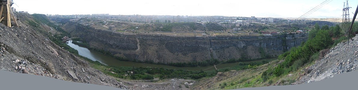 פנורמה של ערוץ נהר הרזדאן ומראה של מחוז דווטשן, ירוואן

עולם החי
עולם החי בנהר כולל 33 מינים של chironomids ו-23 מינים של blackflies.[13] 25 מינים של חסרי חוליות, הכולל שני מינים של רוטייפרה, 13 מינים של קלדוסרה, ו-10 מינים של copepods.[14]
מיני הדגים באזור כוללים את פורל הסוואן (Salmo ischchan)," siga, קרפיון, סרטנים, bojak (Salmo ischchan danilewskii) ובחורף Salmo ischchan ischchan ובקיץ Salmo ischchan aestivalis, וכן דווחו בנהר מינים של סרטנים, כמו גם קאראס ושפע של סרטני נהרות.[15]
זיהום
הנהר מזוהם על ידי שפכים הזורמים ממפעלים חקלאיים, מסחריים, תעשייתיים, מגורים, פיתוח, אך בעיקר על ידי מי שפכים בלתי מטופלים מירוואן. מחקר שבוצע בשנת 2008 מצביע על כך שלאורך 16 ק"מ של הנהר, מ-2 ק"מ במעלה הזרם משפכי הביוב של ירוואן ועד ל-14 ק"מ מעבריהם, המים אינם באיכות מספקת לתמוך בסביבה בריאה עבור בעלי חיים.
קישורים חיצוניים
לקריאה נוספת
- Holding, Deirdre (1 בספטמבר 2014). Armenia: with Nagorno Karabagh. Bradt Travel Guides. ISBN 978-1-84162-555-3.
{{cite book}}: (עזרה); לא תקין|ref=harv(עזרה)
הערות שוליים
- ^ "Armenia". Encyclopædia Britannica. נבדק ב-1 בנובמבר 2015.
{{cite web}}: (עזרה) - ^ "Monitoring Dissolved Oxygen in the Hrazdan River". Acopian Centre for Environment. נבדק ב-18 בנובמבר 2015.
{{cite web}}: (עזרה) - ^ "Armenia:Water resources". FAO Organization. נבדק ב-18 בנובמבר 2015.
{{cite web}}: (עזרה) - ^ "Հրազդան [Hrazdan]". encyclopedia.am. Armenian Encyclopedia.
Հրազդանը (ուրարտերեն՝ Իլդարունի) կամ Զանգուն...
- ^ Hewsen, Robert H. (1992). The Geography of Ananias of Širak: Ašxarhacʻoycʻ, the Long and the Short Recensions. Reichert. p. 192. ISBN 9783882264852.
...the Turkish Zanga; (Urart: Ildaruni; Arm.: Hrazdan)...
- ^ Hewsen, R. H. (15 בדצמבר 1987). "Ayrarat". Encyclopædia Iranica.
...the upper course of the Hrazdan river (Turkish Zanga) which flows from Lake Sevan to the Araxes.
{{cite web}}: (עזרה) - ^ Nansen, Fridtjof (1922). Reports and Papers on the Work for the Refugees. League of Nations. p. 19.
...surrounding Erivan, on both sides of the Zanga River, by the waters of that river...
- ^ Kiesling, Brady (1999). Aediscovering Armenia: An Archaeological/touristic Gazetteer And Map Set For The Historical Monuments Of Armenia. Yerevan. p. 32.
The flow of the Hrazdan (formerly Zangi) river from Lake Sevan past Yerevan to the Arax River...
- ^ Conder, Josiah (1834). A Dictionary of Geography, ancient and modern, etc. London: Thomas Tegg & Son. p. 210.
ERIVAN. A city of Armenia, situated on the river Zengy...
- ^ Perkins, Justin (1843). A Residence of Eight Years in Persia, Among the Nestorian Christians: With Notices of the Muhammedans. Allen, Morrill & Wardwell. p. 129.
There is an imposing citadel, on a hill of moderate elevation about a quarter of a mile south of the town, bordering also on the river Zengy...
- ^ Holding 2014, p. 109.
- ^ "Hrazdan Gorge Palaeolithic Project: the Geoarchaeology". University of Winchester. נבדק ב-18 בנובמבר 2015.
{{cite web}}: (עזרה)(הקישור אינו פעיל, November 2017) - ^ Kachvoryan, E. A. (בפברואר 2007). "The fauna of chironomids and blackflies (Diptera: Chironomidae, Simuliidae) and hydrochemical characteristics of the Hrazdan River (Armenia)". Entomological Review. Springer Link. 87: 73–81. doi:10.1134/S0013873807010071. נבדק ב-18 בנובמבר 2015.
{{cite journal}}: (עזרה) - ^ "Zooplankton changes in the long profile of Hrazdan river, Armenia". Scientific Journal of Chemistry and ecology. 2012. נבדק ב-18 בנובמבר 2015.
{{cite web}}: (עזרה) - ^ "Fishing in Armenia". Fishing Centre. נבדק ב-18 בנובמבר 2015.
{{cite web}}: (עזרה)