
בית דג'ן (נפת שכם) – הבדלי גרסאות
כמו בערך |
מ שילוב מידע מגרסאות קודמות |
||
| שורה 41: | שורה 41: | ||
בעקבות [[מלחמת ששת הימים]] עבר בית דג'ן משליטה ירדנית לישראלית. בעקבות [[הסכמי אוסלו]] הוגדרו 38% מאדמות הכפר כ[[שטח B]], ואילו 62% הנותרים הוגדרו כ[[שטח C]]. |
בעקבות [[מלחמת ששת הימים]] עבר בית דג'ן משליטה ירדנית לישראלית. בעקבות [[הסכמי אוסלו]] הוגדרו 38% מאדמות הכפר כ[[שטח B]], ואילו 62% הנותרים הוגדרו כ[[שטח C]]. |
||
==לקריאה נוספת== |
|||
<div class="mw-content-ltr">{{refbegin}} |
|||
*{{cite book| editor =Barron, J. B. | title = Palestine: Report and General Abstracts of the Census of 1922 |url=https://archive.org/details/PalestineCensus1922 |publisher = Government of Palestine | year = 1923}} |
|||
*{{cite book|last1=Conder|first1=Claude Reignier|authorlink1=Claude Reignier Conder|last2=Kitchener|first2=H. H.|authorlink2=Herbert Kitchener, 1st Earl Kitchener|year=1882|url=https://archive.org/details/surveyofwesternp02conduoft|title=The Survey of Western Palestine: Memoirs of the Topography, Orography, Hydrography, and Archaeology|location=London|publisher=[[Palestine Exploration Fund|Committee of the Palestine Exploration Fund]]|volume=2}} (p. [https://archive.org/stream/surveyofwesternp02conduoft#page/162/mode/1up 162]) |
|||
*{{cite book | last= Dauphin |first = Claudine | title = La Palestine byzantine, Peuplement et Populations |url=https://books.google.com/books?id=FC1mAAAAMAAJ |volume = III : Catalogue | series = BAR International Series 726 | year = 1998 | publisher = Archeopress | location = Oxford|language =French|isbn= 0-860549-05-4}} (p. 771) |
|||
*{{cite book|title=Village Statistics, April, 1945 |url=http://web.nli.org.il/sites/nli/Hebrew/library/Pages/BookReader.aspx?pid=856390|author=Department of Statistics|year=1945|publisher=Government of Palestine}} |
|||
*{{cite book|title=Village Statistics of 1945: A Classification of Land and Area ownership in Palestine|url=http://www.palestineremembered.com/Articles/General-2/Story3150.html|first1=Sami|last1=Hadawi|authorlink=Sami Hadawi|year=1970|publisher=Palestine Liberation Organization Research Center}} |
|||
*{{cite book | last1= Hütteroth |first1=Wolf-Dieter |first2=Kamal | last2=Abdulfattah | title = Historical Geography of Palestine, Transjordan and Southern Syria in the Late 16th Century |url= https://books.google.com/books?id=wqULAAAAIAAJ | year = 1977 | publisher = Erlanger Geographische Arbeiten, Sonderband 5. Erlangen, Germany: Vorstand der Fränkischen Geographischen Gesellschaft|isbn= 3-920405-41-2}} (p. 132) |
|||
*{{cite book | editor = Mills, E. | title = Census of Palestine 1931. Population of Villages, Towns and Administrative Areas |url=https://archive.org/details/CensusOfPalestine1931.PopulationOfVillagesTownsAndAdministrativeAreas | publisher = Government of Palestine | location = Jerusalem | year = 1932}} |
|||
*{{cite book|last=Palmer|first=E. H.|authorlink=Edward Henry Palmer|year=1881|url=https://archive.org/details/surveyofwesternp00conduoft|title=The Survey of Western Palestine: Arabic and English Name Lists Collected During the Survey by Lieutenants Conder and Kitchener, R. E. Transliterated and Explained by E.H. Palmer|publisher=[[Palestine Exploration Fund|Committee of the Palestine Exploration Fund]]}} (p. [https://archive.org/stream/surveyofwesternp00conduoft#page/180/mode/1up 180]) |
|||
{{refend}} |
|||
</div> |
|||
==קישורים חיצוניים== |
==קישורים חיצוניים== |
||
{{ויקישיתוף בשורה}} |
{{ויקישיתוף בשורה}} |
||
גרסה מ־11:41, 14 בספטמבר 2019
שגיאות פרמטריות בתבנית:עיר
פרמטרים [ שנת אוכלוסייה ] לא מופיעים בהגדרת התבנית
פרמטרים ריקים [ שנת צפיפות, שנת מטרופולין ] לא מופיעים בהגדרת התבנית
 | |
| טריטוריה |
|
|---|---|
| נפה | שכם |
| גובה | 525 מטרים |
| אוכלוסייה | |
| ‑ בכפר | 4,229[1] |
| קואורדינטות | 32°11′32″N 35°22′16″E / 32.192138888889°N 35.371141666667°E |
| אזור זמן | UTC +2 |


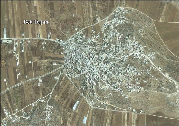
בית דג'ן (בערבית:بيت دجن) הוא כפר פלסטיני במחוז שכם שבצפון הגדה המערבית, הנמצא 10 ק"מ מזרחית לשכם. לפי נתוני הלשכה הפלסטינית המרכזית לסטטיסטיקה, מנה הכפר כ-4,229 נפש באמצע שנת 2016[1].
היסטוריה
במפקד 1922 שנערך על ידי שלטונות המנדט הבריטי, הייתה אוכלוסיית הכפר 487 מוסלמים,[2] ובמפקד 1931 היא גדלה ל-548 מוסלמים אשר שכנו ב-118 בתים.[3]
ב-1945 האוכלוסייה בכפר הייתה 750 מוסלמים, ואילו שטח הקרקע הכולל של הכפר היה 44,076 דונם.
בעקבות מלחמת העצמאות, ולאחר הסכמי שביתת הנשק בתום מלחמת העצמאות של 1949, עברה בית דג'ן משליטה בריטית לירדנית.
בעקבות מלחמת השחרור, ולאחר הסכמי שביתת הנשק של 1949, עבר בית דג'ן לשליטה ירדנית. בסקר האוכלוסין הירדני משנת 1961 נמנו בכפר 926 תושבים[4].
בעקבות מלחמת ששת הימים עבר בית דג'ן משליטה ירדנית לישראלית. בעקבות הסכמי אוסלו הוגדרו 38% מאדמות הכפר כשטח B, ואילו 62% הנותרים הוגדרו כשטח C.
לקריאה נוספת
- Barron, J. B., ed. (1923). Palestine: Report and General Abstracts of the Census of 1922. Government of Palestine.
- Conder, Claude Reignier; Kitchener, H. H. (1882). The Survey of Western Palestine: Memoirs of the Topography, Orography, Hydrography, and Archaeology. Vol. 2. London: Committee of the Palestine Exploration Fund. (p. 162)
- Dauphin, Claudine (1998). La Palestine byzantine, Peuplement et Populations. BAR International Series 726 (בצרפתית). Vol. III : Catalogue. Oxford: Archeopress. ISBN 0-860549-05-4. (p. 771)
- Department of Statistics (1945). Village Statistics, April, 1945. Government of Palestine.
- Hadawi, Sami (1970). Village Statistics of 1945: A Classification of Land and Area ownership in Palestine. Palestine Liberation Organization Research Center.
- Hütteroth, Wolf-Dieter; Abdulfattah, Kamal (1977). Historical Geography of Palestine, Transjordan and Southern Syria in the Late 16th Century. Erlanger Geographische Arbeiten, Sonderband 5. Erlangen, Germany: Vorstand der Fränkischen Geographischen Gesellschaft. ISBN 3-920405-41-2. (p. 132)
- Mills, E., ed. (1932). Census of Palestine 1931. Population of Villages, Towns and Administrative Areas. Jerusalem: Government of Palestine.
- Palmer, E. H. (1881). The Survey of Western Palestine: Arabic and English Name Lists Collected During the Survey by Lieutenants Conder and Kitchener, R. E. Transliterated and Explained by E.H. Palmer. Committee of the Palestine Exploration Fund. (p. 180)
קישורים חיצוניים
- Welcome to Bayt Dajan
- Beit Dajan, Welcome to Palestine
- Survey of Western Palestine, Map 12: IAA, Wikimedia commons
- Beit Dajan village profile, המכון למחקר יישומי - ירושלים, ARIJ
- Beit Dajan, aerial photo, ARIJ
- Beit Dajan
הערות שוליים
- ^ 1 2 מפקד אוכלוסין 2016, באתר של הלשכה הפלסטינית המרכזית לסטטיסטיקה
- ^ Barron, 1923, Table IX, Sub-district of Nablus, p. 24
- ^ Mills, 1932, p.60
- ^ Government of Jordan, Department of Statistics, 1964, p. 25
 | ||
|---|---|---|
| ערים | שכם | 
|
| מועצות מקומיות | עקרבה • עסירה א-שמאלייה • ביתא • חווארה • ג'מאעין • קבלאן • סבסטיה • בית פוריכ | |
| כפרים | עסירה אל-קבלייה • עזמוט • עוורתא • אל-באד'אן • בלאטה אל-בלד • בית דג'ן • בית חסאן • בית איבא • בית אימרין • בית וזן • בזאריה • בורין • בורקה • ג'אלוד • דיר אל-חטב • דיר שרף • דומא • עינאבוס • פורוש בית דג'ן • איג'ניסיניא • ג'וריש • כפר קליל • לובאן א-שרקיה • מאדמא • מג'דל בני פדיל • א-נאקורה • א-נסאריה • אודלה • עוסארין • קריות • קוסין • קוסרה • רוג'ייב • סאלם • סרה • א-סאוויה • תלפית • טלוזה • תל • עוריף • יאנון • יאסיד • יתמא • זאוואתא • זיתא ג'מעין • קריית לוזה | |
| מחנות פליטים | בלאטה | |
| נפות הרשות הפלסטינית | ||