
קובץ:Generalplan Ost map.tiff
גודל התצוגה המקדימה הזאת מסוג JPG של קובץ ה־TIF הזה: 800 × 540 פיקסלים. רזולוציות אחרות: 320 × 216 פיקסלים | 640 × 432 פיקסלים | 1,024 × 691 פיקסלים | 1,166 × 787 פיקסלים.
לקובץ המקורי (1,166 × 787 פיקסלים, גודל הקובץ: 2.63 מ"ב, סוג MIME: image/tiff)
| זהו קובץ שמקורו במיזם ויקישיתוף. תיאורו בדף תיאור הקובץ המקורי (בעברית) מוצג למטה. |
תקציר
| תיאור |
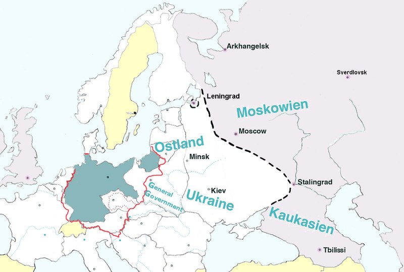
English: Map of Europe, with pre-WW2 borders, showing the extension of Nazi Germany's GENERALPLAN OST worked out 1940-1942.
Legend: Blue-green – Germany (Deutsches Reich). Dotted black line – the extension of detailed plans of a second ”phase of settlement” (Siedlungsphase). Light grey – the greatest extension of Generalplan Ost. The names in blue – Nazi regions called Reichskommissariat : Ostland (1941-1945), Ukraine (1941-1945), Moskowien (never realized), Kaukasien (never realized). Yellow – neutral countries. The map is based on texts and graphics on Deutsche Forschungsgemeinschaft: Der Generalplan Ost der Nationalsozialisten, [1] |
||
| תאריך יצירה | |||
| מקור | נוצר על־ידי מעלה היצירה | ||
| יוצר | Lihagen | ||
| אישורים והיתרים (שימוש חוזר בקובץ זה) |
|
רישיון
אני, בעל זכויות היוצרים על עבודה זו, מפרסם בזאת את העבודה תחת הרישיון הבא:
| קובץ זה זמין לפי תנאי הקדשה עולמית לנחלת הכלל CC0 1.0 של Creative Commons. | |
| האדם ששייך יצירה להיתר הזה הקדיש את היצירה לנחלת הכלל על־ידי ויתור על כל הזכויות שלו או שלה על היצירה בכל העולם לפי חוק זכויות יוצרים, לרבות כל הזכויות הקשורות או הסמוכות כקבוע בחוק. באפשרותך להעתיק, לשנות, להפיץ, או להציג את היצירה, אפילו למטרות מסחריות, וכל זה אפילו מבלי לבקש רשות.
|
היסטוריית הקובץ
ניתן ללחוץ על תאריך/שעה כדי לראות את הקובץ כפי שנראה באותו זמן.
| תאריך/שעה | תמונה ממוזערת | ממדים | משתמש | הערה | |
|---|---|---|---|---|---|
| נוכחית | 20:22, 9 בפברואר 2017 |  | 787 × 1,166 (2.63 מ"ב) | Claude Zygiel | Leningrad |
| 20:18, 9 בפברואר 2017 |  | 787 × 1,166 (2.63 מ"ב) | Claude Zygiel | Sverdlovsk, Tbilissi, borders during the war in green, neutral states in yellow | |
| 20:35, 28 ביולי 2016 |  | 787 × 1,166 (2.63 מ"ב) | Julieta39 | Pre-WW2 borders in grey, Gross-Deutschlands Reich in red, add General-Government | |
| 22:07, 10 באפריל 2011 |  | 787 × 1,166 (2.63 מ"ב) | Lihagen | {{Information |Description ={{en|1=Map of Europe, with pre-WW2 boarders, showing the extension of Nazi Germany's GENERALPLAN OST. Legend: Dark grey – Germany (Deutsches Reich); Dotted black line – the extension of a second ”phase of resattlemen |
שימוש בקובץ
הדף הבא משתמש בקובץ הזה:
שימוש גלובלי בקובץ
אתרי הוויקי השונים הבאים משתמשים בקובץ זה:
- שימוש באתר ar.wikipedia.org
- שימוש באתר cs.wikipedia.org
- שימוש באתר da.wikipedia.org
- שימוש באתר el.wikipedia.org
- שימוש באתר en.wikipedia.org
- שימוש באתר es.wikipedia.org
- שימוש באתר et.wikipedia.org
- שימוש באתר fr.wikipedia.org
- שימוש באתר id.wikipedia.org
- שימוש באתר it.wikipedia.org
- שימוש באתר ja.wikipedia.org
- שימוש באתר mk.wikipedia.org
- שימוש באתר nl.wikipedia.org
- שימוש באתר no.wikipedia.org
- שימוש באתר ro.wikipedia.org
- שימוש באתר ru.wikipedia.org
- שימוש באתר sh.wikipedia.org
- שימוש באתר sk.wikipedia.org
- שימוש באתר sr.wikipedia.org
- שימוש באתר sv.wikipedia.org
- שימוש באתר uk.wikipedia.org
- שימוש באתר zh.wikipedia.org