
קובץ:Antarctic Peninsula satellite image.jpg

גודל התצוגה המקדימה הזאת: 490 × 599 פיקסלים. רזולוציות אחרות: 196 × 240 פיקסלים | 392 × 480 פיקסלים | 628 × 768 פיקסלים | 837 × 1,024 פיקסלים | 1,509 × 1,846 פיקסלים.
לקובץ המקורי (1,509 × 1,846 פיקסלים, גודל הקובץ: 706 ק"ב, סוג MIME: image/jpeg)
| זהו קובץ שמקורו במיזם ויקישיתוף. תיאורו בדף תיאור הקובץ המקורי (בעברית) מוצג למטה. |
תקציר
| תיאור |
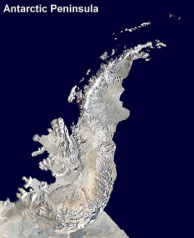
English: Antarctic Peninsula satellite image. An orthographic projection of NASA's Blue Marble data set (1 km resolution global satellite composite). "MODIS observations of polar sea ice were combined with observations of Antarctica made by the National Oceanic and Atmospheric Administration’s AVHRR sensor—the Advanced Very High Resolution Radiometer." Image was generated using a custom C program for handling the Blue Marble files, with orthographic projection formulas from MathWorld.
The black pixels are presumed to be due to missing data in the land/sea mask used in making the original Blue Marble image.
|
||
| תאריך יצירה | (UTC) | ||
| מקור | |||
| יוצר |
|
רישיון
| היצירה הזאת שוחררה לנחלת הכלל על־ידי היוצר שלה, Anna Frodesiak. זה תקף בכל העולם. יש מדינות שבהן הדבר אינו אפשרי על פי חוק, אם כך: |
יומן העלאה מקורי
This image is a derivative work of the following images:
- File:Antarctica_6400px_from_Blue_Marble.jpg licensed with PD-user
- 2006-10-05T14:21:53Z Davepape 6400x6400 (3472802 Bytes) touched up part with missing data
- 2006-10-05T07:49:09Z Davepape 6400x6400 (3472752 Bytes) {{Information |Description=[[w:Antarctica|Antarctica]]. An orthographic projection of NASA's Blue Marble data set (1 km resolution global satellite composite). "MODIS observations of polar sea ice were combined with observa
Uploaded with derivativeFX
היסטוריית הקובץ
ניתן ללחוץ על תאריך/שעה כדי לראות את הקובץ כפי שנראה באותו זמן.
| תאריך/שעה | תמונה ממוזערת | ממדים | משתמש | הערה | |
|---|---|---|---|---|---|
| נוכחית | 02:08, 6 באפריל 2009 | | 1,846 × 1,509 (706 ק"ב) | Anna Frodesiak | {{Information |Description=Antarctic Peninsula satellite image. An orthographic projection of NASA's Blue Marble data set (1 km resolution global satellite composite). "MODIS observations of polar sea ice were combined with observations of Antarctica made |
שימוש בקובץ
הדף הבא משתמש בקובץ הזה:
שימוש גלובלי בקובץ
אתרי הוויקי השונים הבאים משתמשים בקובץ זה:
- שימוש באתר af.wikipedia.org
- שימוש באתר ast.wikipedia.org
- שימוש באתר bs.wikipedia.org
- שימוש באתר ca.wikipedia.org
- שימוש באתר da.wikipedia.org
- שימוש באתר en.wikipedia.org
- Antarctic Peninsula
- Mount Jackson (Antarctica)
- Trinity Peninsula
- Bowman Coast
- Breaker Island
- Dream Island
- Christine Island
- Cormorant Island
- Eichorst Island
- Shortcut Island
- Biscoe Point
- Loubet Coast
- Halfway Island (Palmer Archipelago)
- Gerlache Strait
- Hermit Island (Antarctic)
- Humble Island
- Janus Island
- Laggard Island
- Limitrophe Island
- Lipps Island
- Ohlin Island
- Outcast Islands
- Torgersen Island
- Spume Island
- Stepping Stones (islands)
- Surge Rocks
- Orville Coast
- Black Coast
- Wilkins Coast
- Dyer Plateau
- Fallières Coast
- English Coast
- Galindez Island
- Nordenskjöld Coast
- Quintana Island
- Doumer Island
- Bremen Island
- Neumayer Channel
- Smooth Island (Antarctica)
- Wilhelm Archipelago
- Betbeder Islands
- Meek Channel