
קובץ:Basse-Normandie region relief location map.jpg

גודל התצוגה המקדימה הזאת: 740 × 600 פיקסלים. רזולוציות אחרות: 296 × 240 פיקסלים | 592 × 480 פיקסלים | 948 × 768 פיקסלים | 1,264 × 1,024 פיקסלים | 1,414 × 1,146 פיקסלים.
לקובץ המקורי (1,414 × 1,146 פיקסלים, גודל הקובץ: 309 ק"ב, סוג MIME: image/jpeg)
| זהו קובץ שמקורו במיזם ויקישיתוף. תיאורו בדף תיאור הקובץ המקורי (בעברית) מוצג למטה. |
תקציר
| מיקום המצלמה | | תמונה זו ותמונות נוספות במיקום: OpenStreetMap |
|---|
| תיאור |
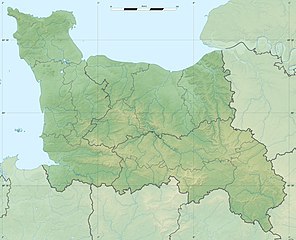
English: Blank physical map of the region of Lower Normandy, France, for geo-location purpose, with distinct boundaries for regions, departments and arrondissements.
Français : Carte physique vierge de la région de Basse-Normandie, France, destinée à la géolocalisation, avec limite distincte des régions, départements et arrondissements. Scales:
Equirectangular projection, WGS84 datum
Geographic limits of the map:
|
||
| תאריך יצירה | |||
| מקור |
נוצר על־ידי מעלה היצירה
|
||
| יוצר | Eric Gaba (Sting - fr:Sting) | ||
| אישורים והיתרים (שימוש חוזר בקובץ זה) |
|
||
| גרסאות אחרות |
|

רישיון
אני, בעל זכויות היוצרים על היצירה הזאת, מפרסם אותה בזאת תחת הרישיונות הבאים:
הקובץ הזה מתפרסם לפי תנאי רישיון קריאייטיב קומונז ייחוס-שיתוף זהה 3.0 לא מותאם.
- הנכם רשאים:
- לשתף – להעתיק, להפיץ ולהעביר את העבודה
- לערבב בין עבודות – להתאים את העבודה
- תחת התנאים הבאים:
- ייחוס – יש לתת ייחוס הולם, לתת קישור לרישיון, ולציין אם נעשו שינויים. אפשר לעשות את זה בכל צורה סבירה, אבל לא בשום צורה שמשתמע ממנה שמעניק הרישיון תומך בך או בשימוש שלך.
- שיתוף זהה – אם תיצרו רמיקס, תשנו, או תבנו על החומר, חובה עליכם להפיץ את התרומות שלך לפי תנאי רישיון זהה או תואם למקור.

|
מוענקת בכך הרשות להעתיק, להפיץ או לשנות את המסמך הזה, לפי תנאי הרישיון לשימוש חופשי במסמכים של גנו, גרסה 1.2 או כל גרסה מאוחרת יותר שתפורסם על־ידי המוסד לתוכנה חופשית; ללא פרקים קבועים, ללא טקסט עטיפה קדמית וללא טקסט עטיפה אחורית. עותק של הרישיון כלול בפרק שכותרתו הרישיון לשימוש חופשי במסמכים של גנו. |
הנכם מוזמנים לבחור את הרישיון הרצוי בעיניכם.
היסטוריית הקובץ
ניתן ללחוץ על תאריך/שעה כדי לראות את הקובץ כפי שנראה באותו זמן.
| תאריך/שעה | תמונה ממוזערת | ממדים | משתמש | הערה | |
|---|---|---|---|---|---|
| נוכחית | 00:09, 19 ביולי 2010 | | 1,146 × 1,414 (309 ק"ב) | Sting | Color profile |
| 03:52, 17 בינואר 2010 |  | 1,146 × 1,414 (321 ק"ב) | Sting | == {{int:filedesc}} == {{Location|48|57|00|N|00|28|30|W|scale:500000}} <br/> {{Information |Description={{en|Blank physical map of the region of Lower Normandy, France, for geo-location purpose, with distinct boundaries for regions, |
שימוש בקובץ
הדף הבא משתמש בקובץ הזה:
שימוש גלובלי בקובץ
אתרי הוויקי השונים הבאים משתמשים בקובץ זה:
- שימוש באתר ar.wikipedia.org
- שימוש באתר bg.wikipedia.org
- שימוש באתר ca.wikipedia.org
- שימוש באתר ceb.wikipedia.org
- שימוש באתר ce.wikipedia.org
- שימוש באתר cs.wikipedia.org
- שימוש באתר de.wikipedia.org
- שימוש באתר el.wikipedia.org
- שימוש באתר en.wikipedia.org
- שימוש באתר eo.wikipedia.org
- שימוש באתר es.wikipedia.org
- שימוש באתר fa.wikipedia.org
- שימוש באתר fo.wikipedia.org
- שימוש באתר fr.wikipedia.org
- Bataille de Tinchebray
- Bataille de Normandie
- Utah Beach
- Sword Beach
- Gold Beach
- Juno Beach
- Bataille de Caen
- Opération Epsom
- Bataille de Formigny
- Débarquement de Normandie
- Cap de Carteret
- Siège de Granville
- Opération Bluecoat
- Bataille de Villers-Bocage
- Opération Spring
- Opération Totalize
- Forêt de Saint-Sever
- Abbaye Notre-Dame de la Trappe
- Opération Perch
- Bataille de Carentan