קובץ:Chennakesava temple, Somanathapura.jpg

תוכן הדף אינו נתמך בשפות אחרות.
מתוך ויקיפדיה, האנציקלופדיה החופשית

לקובץ המקורי(2,475 × 2,700 פיקסלים, גודל הקובץ: 395 ק"ב, סוג MIME‏: image/jpeg)

ויקישיתוף זהו קובץ שמקורו במיזם ויקישיתוף. תיאורו בדף תיאור הקובץ המקורי (בעברית) מוצג למטה.

תקציר

תיאור
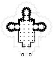
English: This is an SVG format plan and architectural drawing of a historic Indian temple or monument. An alternate high resolution JPEG version of this file has also been uploaded to the wikimedia commons.
 
W3C-validity not checked.

The drawing:

  • This is the floor plan of the often visited Hoysala-era, Keshava temple (Kesava, Chennakesava temple) in Somanathapura. It is about 38 kilometers from Mysuru city, Karnataka.
  • The mid-13th-century ornate temple illustrates the Hoysala architecture. The temple is in a courtyard with a pillared corridor of small shrines (damaged, defaced to differing degrees). The main temple in the center is on a high star-shaped platform with three symmetrical sanctums (trikuta garbhagriha), set in a square matrix (89' x 89') oriented along the east–west and north–south axes. The sanctums share a common community hall (sabha-mandapa) with many pillars. The outer walls, the inner walls, the pillars and the ceiling of the temple are intricately carved with Hindu legends such as those from the Ramayana (southern section), the Mahabharata (northern section) and the Bhagavata Purana (western section of the main temple).
  • The temple's architectural plan follows the square and circle principle found in historic Sanskrit texts.
  • This temple should not be confused with numerous other historic, intricately carved Chennakesava temples found in Karnataka, Telangana and Andhra Pradesh.
  • The relative scale and relative dimensions in this architectural drawing are close to the actual but neither exact nor complete. The plan illustrates the design and layout, but some intricate details or parts of the temple may not be shown. In cases where exact measurements were not feasible, the drawing uses best approximations and rounds the best measurements feasible. This drawing uses, in part, measurements made and published by the Mysore Archaeological department between 1906 and 1911.
Note: Please do not overwrite this file. To modify or correct or load a new version, please upload a new separate file and link the new other version(s) to this file as recommended by wikimedia commons guidelines.
תאריך יצירה
מקור נוצר על־ידי מעלה היצירה
יוצר Ms Sarah Welch

רישיון

אני, בעל זכויות היוצרים על עבודה זו, מפרסם בזאת את העבודה תחת הרישיון הבא:
Creative Commons CC-Zero קובץ זה זמין לפי תנאי הקדשה עולמית לנחלת הכלל CC0 1.0 של Creative Commons.
האדם ששייך יצירה להיתר הזה הקדיש את היצירה לנחלת הכלל על־ידי ויתור על כל הזכויות שלו או שלה על היצירה בכל העולם לפי חוק זכויות יוצרים, לרבות כל הזכויות הקשורות או הסמוכות כקבוע בחוק. באפשרותך להעתיק, לשנות, להפיץ, או להציג את היצירה, אפילו למטרות מסחריות, וכל זה אפילו מבלי לבקש רשות.

כיתובים

נא להוסיף משפט שמסביר מה הקובץ מייצג
Floor plan of the Kesava temple, Somnathpur Karnataka

פריטים שמוצגים בקובץ הזה

מוצג

12°16'32.700"N, 76°52'53.602"E

image/jpeg

checksum אנגלית

407a1b95e93d781374d994a870e076f5e08e7558

הוגדר לפי: SHA-1 אנגלית

403,968 בית

2,700 פיקסל

2,475 פיקסל

היסטוריית הקובץ

ניתן ללחוץ על תאריך/שעה כדי לראות את הקובץ כפי שנראה באותו זמן.

תאריך/שעהתמונה ממוזערתממדיםמשתמשהערה
נוכחית02:33, 15 ביולי 2021תמונה ממוזערת לגרסה מ־02:33, 15 ביולי 2021‪2,700 × 2,475‬ (395 ק"ב)Ms Sarah WelchUploaded own work with UploadWizard

הדף הבא משתמש בקובץ הזה:

שימוש גלובלי בקובץ

אתרי הוויקי השונים הבאים משתמשים בקובץ זה: