
קובץ:Ctcolony.png

גודל התצוגה המקדימה הזאת: 800 × 560 פיקסלים. רזולוציות אחרות: 320 × 224 פיקסלים | 640 × 448 פיקסלים | 1,024 × 717 פיקסלים | 1,428 × 1,000 פיקסלים.
לקובץ המקורי (1,428 × 1,000 פיקסלים, גודל הקובץ: 817 ק"ב, סוג MIME: image/png)
| זהו קובץ שמקורו במיזם ויקישיתוף. תיאורו בדף תיאור הקובץ המקורי (בעברית) מוצג למטה. |
תקציר
| תיאור |
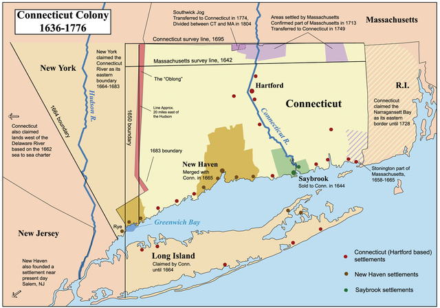
This is a map showing the Connecticut, New Haven, and Saybrook colonies from 1636-1776. It includes the territorial disputes between Connecticut and its neighbors during that time period. It does not show Connecticut's western land claims and dispute with Pennsylvania. Based primarily on descriptions from The Boundary Disputes of Connecticut by Clarence Winthrop Bowen. James R. Osgood and Company, Boston, 1882. |
| תאריך יצירה | 12 באוקטובר 2006 (תאריך העלאה מקורי) |
| מקור | לא סופק מקור מכונה קריא. ההנחה היא כי היצירה נוצרה על ידי מעלה היצירה (בהתבסס על תבנית הרישיון). |
| יוצר | לא סופק יוצר ששמו ניתן לקריאה במכונה. בהתבסס על תביעות זכויות יוצרים, ההנחה היא כי Kmusser הוא היוצר. |
רישיון
אני, בעל זכויות היוצרים על עבודה זו, מפרסם בזאת את העבודה תחת הרישיון הבא:
הקובץ הזה מתפרסם לפי תנאי רישיון קריאייטיב קומונז ייחוס-שיתוף זהה 2.5 כללי.
- הנכם רשאים:
- לשתף – להעתיק, להפיץ ולהעביר את העבודה
- לערבב בין עבודות – להתאים את העבודה
- תחת התנאים הבאים:
- ייחוס – יש לתת ייחוס הולם, לתת קישור לרישיון, ולציין אם נעשו שינויים. אפשר לעשות את זה בכל צורה סבירה, אבל לא בשום צורה שמשתמע ממנה שמעניק הרישיון תומך בך או בשימוש שלך.
- שיתוף זהה – אם תיצרו רמיקס, תשנו, או תבנו על החומר, חובה עליכם להפיץ את התרומות שלך לפי תנאי רישיון זהה או תואם למקור.
Format

|
יש ליצור מחדש את התמונה historical map הזו באמצעות גרפיקה וקטורית כדוגמת קובץ SVG. לפעולה זו מספר יתרונות, כפי שניתן לקרוא (באנגלית) בדף Commons:Media for cleanup. אם ברשותכם קובץ SVG, אנא העלו אותו. לאחר מכן, החליפו תבנית זו בתבנית
{{vector version available|שם הקובץ.svg}} |
היסטוריית הקובץ
ניתן ללחוץ על תאריך/שעה כדי לראות את הקובץ כפי שנראה באותו זמן.
| תאריך/שעה | תמונה ממוזערת | ממדים | משתמש | הערה | |
|---|---|---|---|---|---|
| נוכחית | 07:06, 2 ביוני 2014 | | 1,000 × 1,428 (817 ק"ב) | JeffyP | I'm here to make the world a little bit smaller ☺ |
| 22:19, 10 בינואר 2008 |  | 1,000 × 1,428 (909 ק"ב) | Kmusser | Major revision to include disputes with Massachusetts and Rhode Island. | |
| 19:54, 12 באוקטובר 2006 |  | 680 × 800 (190 ק"ב) | Kmusser | == Summary == This is a map showing the Connecticut, New Haven, and Saybrook colonies from 1636-1776. It includes the territorial dispute between Connecticut |
שימוש בקובץ
הדף הבא משתמש בקובץ הזה:
שימוש גלובלי בקובץ
אתרי הוויקי השונים הבאים משתמשים בקובץ זה:
- שימוש באתר bg.wikipedia.org
- שימוש באתר bn.wikipedia.org
- שימוש באתר ce.wikipedia.org
- שימוש באתר da.wikipedia.org
- שימוש באתר de.wikipedia.org
- שימוש באתר en.wikipedia.org
- Connecticut
- Fishers Island, New York
- New Haven Colony
- History of Connecticut
- Connecticut Colony
- John Haynes (governor)
- Saybrook Colony
- User:Kmusser/Images
- List of colonial governors of Connecticut
- History of Long Island
- New England Colonies
- Portal:Connecticut
- Thomas Powell (American landowner)
- Border disputes between New York and Connecticut
- שימוש באתר en.wikiversity.org
- שימוש באתר es.wikipedia.org
- שימוש באתר fr.wikipedia.org
- שימוש באתר fy.wikipedia.org
- שימוש באתר hu.wikipedia.org
- שימוש באתר hy.wikipedia.org
- שימוש באתר id.wikipedia.org
- שימוש באתר it.wikipedia.org
- שימוש באתר ja.wikipedia.org