
קובץ:European Union Exclusive Economic Zones.PNG
גודל התצוגה המקדימה הזאת: 767 × 600 פיקסלים. רזולוציות אחרות: 307 × 240 פיקסלים | 614 × 480 פיקסלים | 982 × 768 פיקסלים | 1,280 × 1,001 פיקסלים | 2,560 × 2,002 פיקסלים | 4,572 × 3,576 פיקסלים.
לקובץ המקורי (4,572 × 3,576 פיקסלים, גודל הקובץ: 1.65 מ"ב, סוג MIME: image/png)
| זהו קובץ שמקורו במיזם ויקישיתוף. תיאורו בדף תיאור הקובץ המקורי (בעברית) מוצג למטה. |
תקציר
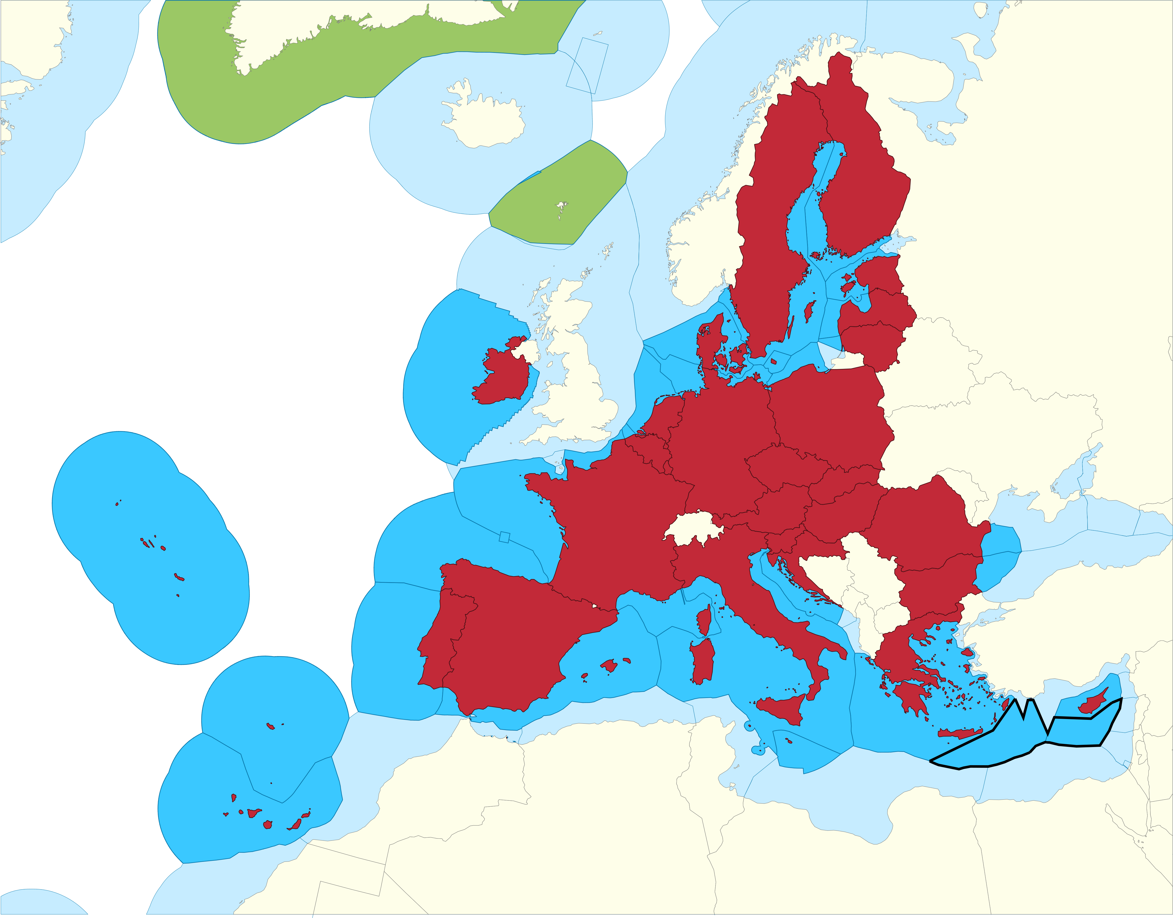
| תיאור |
English: European Union Member states Exclusive Economic Zones |
|||
| תאריך יצירה | ||||
| מקור |
EU member states Exclusive Economic Zones
EU member states overseas territories Exclusive Economic Zones
EU member states
Disputed Exclusive Economic Zones |
|||
| יוצר | Sette-quattro, replacing the previous work done by Luis_wiki | |||
| אישורים והיתרים (שימוש חוזר בקובץ זה) |
Own work | |||
| גרסאות אחרות |
|


רישיון
| ברצוני, בעלי זכויות היוצרים על יצירה זו, לשחרר יצירה זו לנחלת הכלל. זה תקף בכל העולם. יש מדינות שבהן הדבר אינו אפשרי על פי חוק, אם כך: אני מעניק לכל אחד את הזכות להשתמש בעבודה זו לכל מטרה שהיא, ללא תנאים כלשהם, אלא אם כן תנאים כאלה נדרשים על פי חוק. |
היסטוריית הקובץ
ניתן ללחוץ על תאריך/שעה כדי לראות את הקובץ כפי שנראה באותו זמן.
| תאריך/שעה | תמונה ממוזערת | ממדים | משתמש | הערה | |
|---|---|---|---|---|---|
| נוכחית | 14:14, 17 בפברואר 2021 | | 3,576 × 4,572 (1.65 מ"ב) | Ahmetlii | higher resolution |
| 14:09, 17 בפברואר 2021 |  | 997 × 1,280 (308 ק"ב) | Ahmetlii | added the disputed EEZ border per en:Cyprus–Turkey maritime zones dispute | |
| 00:33, 9 בספטמבר 2020 |  | 3,566 × 4,572 (1.22 מ"ב) | Sette-quattro | updated without UK, clearer boundaries | |
| 11:54, 16 ביולי 2011 |  | 294 × 485 (86 ק"ב) | Epipelagic | Somewhat simplified the map | |
| 14:12, 23 בדצמבר 2010 |  | 298 × 489 (19 ק"ב) | Begg maps | {{Information |Description={{es|1=-}} |Source=- |Author=- |Date=- |Permission= |other_versions= }} | |
| 02:31, 28 באוגוסט 2007 |  | 298 × 489 (19 ק"ב) | Luis wiki | {{Information |Description= European Union Member states Exclusive Economic Zones |Source= Own work over screen capture of Map Interface of VLIZ Maritime Boundaries Geodatabase (http://w2.vliz.be/vmdcdata/marbound/geointerface.php) |Date= 28 August 2007 |
שימוש בקובץ
הדף הבא משתמש בקובץ הזה:
שימוש גלובלי בקובץ
אתרי הוויקי השונים הבאים משתמשים בקובץ זה:
- שימוש באתר ar.wikipedia.org
- שימוש באתר ast.wikipedia.org
- שימוש באתר ca.wikipedia.org
- שימוש באתר cs.wikipedia.org
- שימוש באתר en.wikipedia.org
- שימוש באתר es.wikipedia.org
- שימוש באתר eu.wikipedia.org
- שימוש באתר fi.wikipedia.org
- שימוש באתר id.wikipedia.org
- שימוש באתר it.wikipedia.org
- שימוש באתר ja.wikipedia.org
- שימוש באתר ko.wikipedia.org
- שימוש באתר no.wikipedia.org
- שימוש באתר pt.wikipedia.org
- שימוש באתר sv.wikipedia.org
- שימוש באתר uk.wikipedia.org
- שימוש באתר zh.wikipedia.org