
קובץ:Expulsion map of the Circassians in 19th century.PNG
אין גרסה ברזולוציה גבוהה יותר.
Expulsion_map_of_the_Circassians_in_19th_century.PNG (491 × 445 פיקסלים, גודל הקובץ: 15 ק"ב, סוג MIME: image/png)
| זהו קובץ שמקורו במיזם ויקישיתוף. תיאורו בדף תיאור הקובץ המקורי (בעברית) מוצג למטה. |
תקציר
| תיאור |
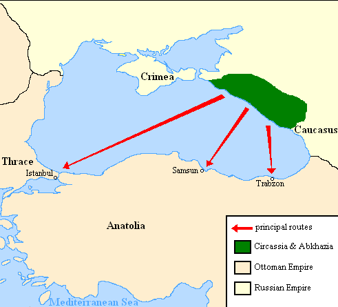
English: Map showing the location of Circassia and the expulsion routes (1859-1864) of the Circassians and other Caucasian peoples to the Ottoman Empire, after the Russian annexation of the North-Caucasus following the Crimean War of 1853-1856.
I used the information of the following two maps: http://www.circassianworld.com/CIRCASSIA1840.jpg And the books: The Northwest Caucasus: past, present, future, Walter Richmond The forgotten minorities of Eastern Europe, Arno TannerРусский: Карта с указанием местонахождения Черкесии и высылки маршрутов (1859-1864) от черкесов и других кавказских народов в состав Османской империи, после русской аннексии Северо-Кавказского следующие Крымской войны 1853-1856 гг. |
| תאריך יצירה | |
| מקור | נוצר על־ידי מעלה היצירה |
| יוצר | DragonTiger23 |
רישיון
| ברצוני, בעלי זכויות היוצרים על יצירה זו, לשחרר יצירה זו לנחלת הכלל. זה תקף בכל העולם. יש מדינות שבהן הדבר אינו אפשרי על פי חוק, אם כך: אני מעניק לכל אחד את הזכות להשתמש בעבודה זו לכל מטרה שהיא, ללא תנאים כלשהם, אלא אם כן תנאים כאלה נדרשים על פי חוק. |
היסטוריית הקובץ
ניתן ללחוץ על תאריך/שעה כדי לראות את הקובץ כפי שנראה באותו זמן.
| תאריך/שעה | תמונה ממוזערת | ממדים | משתמש | הערה | |
|---|---|---|---|---|---|
| נוכחית | 23:06, 5 ביולי 2013 | | 445 × 491 (15 ק"ב) | Irānshahr | |
| 05:01, 4 ביולי 2013 |  | 445 × 491 (15 ק"ב) | Irānshahr | Olahus is correct. | |
| 12:23, 3 ביולי 2013 |  | 445 × 491 (15 ק"ב) | DragonTiger23 | Reverted to version as of 18:05, 11 February 2011 | |
| 16:23, 9 בדצמבר 2011 |  | 445 × 491 (15 ק"ב) | Olahus | The Circassian inhabited region was actually much bigger. | |
| 21:05, 11 בפברואר 2011 |  | 445 × 491 (15 ק"ב) | DragonTiger23 | {{Information |Description ={{en|1=Map showing the location of Circassia and the expulsion routes (1859-1864) of the Circassians and other Caucasian peoples to the Ottoman Empire, after the Russian annexation of the North-Caucasus following the Crimean |
שימוש בקובץ
![]() אין בוויקיפדיה דפים המשתמשים בקובץ זה.
אין בוויקיפדיה דפים המשתמשים בקובץ זה.
שימוש גלובלי בקובץ
אתרי הוויקי השונים הבאים משתמשים בקובץ זה:
- שימוש באתר bg.wikipedia.org
- שימוש באתר ca.wikipedia.org
- שימוש באתר de.wikipedia.org
- שימוש באתר it.wikipedia.org
- שימוש באתר ja.wikipedia.org
- שימוש באתר lmo.wikipedia.org
- שימוש באתר nl.wikipedia.org
- שימוש באתר pl.wikipedia.org
- שימוש באתר ru.wikipedia.org
- שימוש באתר ru.wikinews.org
- שימוש באתר sh.wikipedia.org
- שימוש באתר tr.wikipedia.org