
קובץ:Hampshire UK locator map 2010.svg

גודל התצוגה המקדימה הזאת מסוג PNG של קובץ ה־SVG הזה: 494 × 600 פיקסלים. רזולוציות אחרות: 198 × 240 פיקסלים | 395 × 480 פיקסלים | 633 × 768 פיקסלים | 843 × 1,024 פיקסלים | 1,687 × 2,048 פיקסלים | 1,108 × 1,345 פיקסלים.
לקובץ המקורי (קובץ SVG, הגודל המקורי: 1,108 × 1,345 פיקסלים, גודל הקובץ: 302 ק"ב)
| זהו קובץ שמקורו במיזם ויקישיתוף. תיאורו בדף תיאור הקובץ המקורי (בעברית) מוצג למטה. |
תקציר
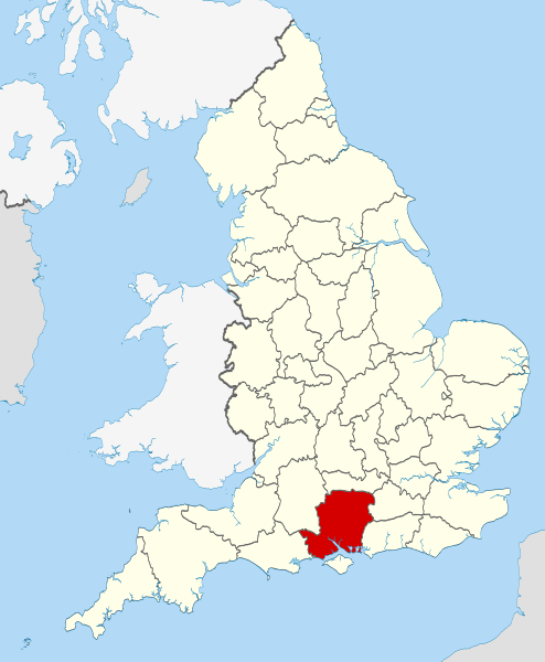
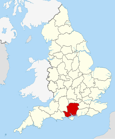
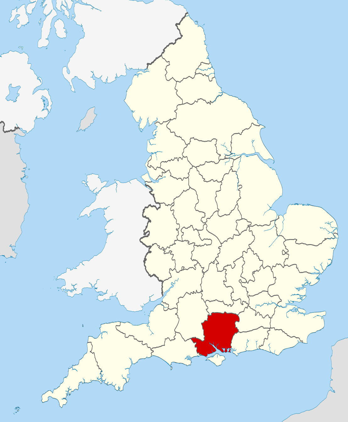
| תיאור | Location of the ceremonial county of Hampshire within England. |
| תאריך יצירה | |
| מקור |
National Geospatial-Intelligence Agency
|
| יוצר | Nilfanion |
רישיון
אני, בעל זכויות היוצרים על היצירה הזאת, מפרסם אותה בזאת תחת הרישיונות הבאים:
הקובץ הזה מתפרסם לפי תנאי רישיון קריאייטיב קומונז ייחוס-שיתוף זהה 3.0 לא מותאם.
- הנכם רשאים:
- לשתף – להעתיק, להפיץ ולהעביר את העבודה
- לערבב בין עבודות – להתאים את העבודה
- תחת התנאים הבאים:
- ייחוס – יש לתת ייחוס הולם, לתת קישור לרישיון, ולציין אם נעשו שינויים. אפשר לעשות את זה בכל צורה סבירה, אבל לא בשום צורה שמשתמע ממנה שמעניק הרישיון תומך בך או בשימוש שלך.
- שיתוף זהה – אם תיצרו רמיקס, תשנו, או תבנו על החומר, חובה עליכם להפיץ את התרומות שלך לפי תנאי רישיון זהה או תואם למקור.

|
מוענקת בכך הרשות להעתיק, להפיץ או לשנות את המסמך הזה, לפי תנאי הרישיון לשימוש חופשי במסמכים של גנו, גרסה 1.2 או כל גרסה מאוחרת יותר שתפורסם על־ידי המוסד לתוכנה חופשית; ללא פרקים קבועים, ללא טקסט עטיפה קדמית וללא טקסט עטיפה אחורית. עותק של הרישיון כלול בפרק שכותרתו הרישיון לשימוש חופשי במסמכים של גנו. |
הנכם מוזמנים לבחור את הרישיון הרצוי בעיניכם.

|
This is one of the images forming part of the Valued image set: Locator maps of the Ceremonial counties of England on Wikimedia Commons. The image set has been assessed under the valued image set criteria and is considered the most valued set on Commons within the scope:
Locator maps of the Ceremonial counties of England
You can see its nomination at Commons:Valued image candidates/Locator maps of English ceremonial counties. |
היסטוריית הקובץ
ניתן ללחוץ על תאריך/שעה כדי לראות את הקובץ כפי שנראה באותו זמן.
| תאריך/שעה | תמונה ממוזערת | ממדים | משתמש | הערה | |
|---|---|---|---|---|---|
| נוכחית | 01:37, 24 בנובמבר 2010 | | 1,345 × 1,108 (302 ק"ב) | Nilfanion | == Summary == {{Information |Description=Location of the ceremonial county of Hampshire within England. |Source=Ordnance Survey [https://www.ordnancesurvey.co.uk/opendatadownload/products.html OpenData]: *County bound |
שימוש בקובץ
![]() אין בוויקיפדיה דפים המשתמשים בקובץ זה.
אין בוויקיפדיה דפים המשתמשים בקובץ זה.
שימוש גלובלי בקובץ
אתרי הוויקי השונים הבאים משתמשים בקובץ זה:
- שימוש באתר af.wikipedia.org
- שימוש באתר ar.wikipedia.org
- שימוש באתר ast.wikipedia.org
- שימוש באתר be-tarask.wikipedia.org
- שימוש באתר bg.wikipedia.org
- שימוש באתר ca.wikipedia.org
- שימוש באתר ceb.wikipedia.org
- שימוש באתר cs.wikipedia.org
- שימוש באתר dag.wikipedia.org
- שימוש באתר en.wikipedia.org
- Hampshire
- Lovedean
- Bramdean Common
- Matley Bog
- Spithead
- Mengham
- Tourner Bury
- Hill Head
- Fratton
- Appleshaw
- Hart Plain
- Coombe, Hampshire
- Easton, Hampshire
- Freefolk
- Turgis Green
- Hambledon, Hampshire
- Avon Valley Path
- Clarendon Way
- King's Way
- Pilgrims' Trail
- Bentley, Hampshire
- Hangers Way
- Three Castles Path
- Strawberry Trail
- Soberton and Newtown Millennium Walk 2000
- Sutton Scotney
- Castleman Trailway
- Blackwater Valley Path
- Pilot Hill, Hampshire
- Queen Elizabeth Country Park
- North Waltham
- Cliddesden
- Baybridge, Hampshire
- Farther Common
- Lychpit
- Spanish Green
- Template:Hampshire-geo-stub
- Abbots Worthy
- Litchfield, Hampshire