
קובץ:History of Korea-476.PNG

גודל התצוגה המקדימה הזאת: 507 × 599 פיקסלים. רזולוציות אחרות: 203 × 240 פיקסלים | 406 × 480 פיקסלים | 970 × 1,146 פיקסלים.
לקובץ המקורי (970 × 1,146 פיקסלים, גודל הקובץ: 866 ק"ב, סוג MIME: image/png)
| זהו קובץ שמקורו במיזם ויקישיתוף. תיאורו בדף תיאור הקובץ המקורי (בעברית) מוצג למטה. |
תקציר
| תיאור |
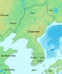
English: The map of history of Korea in 476, the moment of greatest territorial expansion of Goguryeo.
한국어: 한국사 지도 - 476년, 고구려 전성기때의 지도. |
| תאריך יצירה | |
| מקור | נוצר על־ידי מעלה היצירה |
| יוצר | Myself |
רישיון
אני, בעל זכויות היוצרים על עבודה זו, מפרסם בזאת את העבודה תחת הרישיון הבא:
הקובץ הזה מתפרסם לפי תנאי רישיון קריאייטיב קומונז ייחוס-שיתוף זהה 3.0 לא מותאם.
- הנכם רשאים:
- לשתף – להעתיק, להפיץ ולהעביר את העבודה
- לערבב בין עבודות – להתאים את העבודה
- תחת התנאים הבאים:
- ייחוס – יש לתת ייחוס הולם, לתת קישור לרישיון, ולציין אם נעשו שינויים. אפשר לעשות את זה בכל צורה סבירה, אבל לא בשום צורה שמשתמע ממנה שמעניק הרישיון תומך בך או בשימוש שלך.
- שיתוף זהה – אם תיצרו רמיקס, תשנו, או תבנו על החומר, חובה עליכם להפיץ את התרומות שלך לפי תנאי רישיון זהה או תואם למקור.
היסטוריית הקובץ
ניתן ללחוץ על תאריך/שעה כדי לראות את הקובץ כפי שנראה באותו זמן.
| תאריך/שעה | תמונה ממוזערת | ממדים | משתמש | הערה | |
|---|---|---|---|---|---|
| נוכחית | 11:51, 4 באוקטובר 2008 | | 1,146 × 970 (866 ק"ב) | Historiographer~commonswiki | {{Information |Description= |Source= |Date= |Author= |Permission= |other_versions= }} |
| 08:37, 3 ביולי 2008 |  | 1,146 × 970 (571 ק"ב) | Historiographer~commonswiki | {{Information |Description= |Source= |Date= |Author= |Permission= |other_versions= }} | |
| 17:48, 14 ביוני 2008 |  | 1,146 × 970 (873 ק"ב) | Historiographer~commonswiki | {{Information |Description= |Source= |Date= |Author= |Permission= |other_versions= }} | |
| 17:46, 14 ביוני 2008 |  | 1,146 × 970 (568 ק"ב) | Historiographer~commonswiki | {{Information |Description= |Source= |Date= |Author= |Permission= |other_versions= }} | |
| 16:47, 12 ביוני 2008 |  | 1,146 × 970 (874 ק"ב) | Historiographer~commonswiki | {{Information |Description={{en|1=The map of history of Korea in 476, The greatest territory expansion of Goguryeo. }} {{ko|1=한국사 지도 - 476년, 고구려 전성기때의 지도.}} |Source=Self-made |Author=Myself |Date=2008-06-10 |Permission= |ot |
שימוש בקובץ
הדף הבא משתמש בקובץ הזה:
שימוש גלובלי בקובץ
אתרי הוויקי השונים הבאים משתמשים בקובץ זה:
- שימוש באתר ang.wikipedia.org
- שימוש באתר ast.wikipedia.org
- שימוש באתר azb.wikipedia.org
- שימוש באתר az.wikipedia.org
- שימוש באתר ba.wikipedia.org
- שימוש באתר be-tarask.wikipedia.org
- שימוש באתר be.wikipedia.org
- שימוש באתר br.wikipedia.org
- שימוש באתר ca.wikipedia.org
- שימוש באתר cdo.wikipedia.org
- שימוש באתר ckb.wikipedia.org
- שימוש באתר cs.wikipedia.org
- שימוש באתר cy.wikipedia.org
- שימוש באתר da.wikipedia.org
- שימוש באתר da.wikibooks.org
- שימוש באתר de.wikipedia.org
- שימוש באתר en.wikipedia.org