
קובץ:Klimagürtel-der-erde-polargebiete.png

גודל התצוגה המקדימה הזאת: 800 × 400 פיקסלים. רזולוציות אחרות: 320 × 160 פיקסלים | 640 × 320 פיקסלים | 1,024 × 512 פיקסלים | 1,280 × 640 פיקסלים | 3,600 × 1,800 פיקסלים.
לקובץ המקורי (3,600 × 1,800 פיקסלים, גודל הקובץ: 674 ק"ב, סוג MIME: image/png)
| זהו קובץ שמקורו במיזם ויקישיתוף. תיאורו בדף תיאור הקובץ המקורי (בעברית) מוצג למטה. |
תקציר
| תיאור |
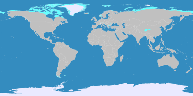
English: This map shows the Earth zones with a polar climate.
Ice cap climate
Tundra climate
Deutsch: Diese Karte stellt die polare Eisklimazone der Erde dar.
Eisklima
Tundrenklima |
| תאריך יצירה | |
| מקור |
English: Own work on the basis of the following data: Deutsch: Selbst erstellt auf Basis dieser Geodaten:
|
| יוצר | LordToran |
| אישורים והיתרים (שימוש חוזר בקובץ זה) |
|
| גרסאות אחרות |
 |
רישיון
הקובץ הזה מתפרסם לפי תנאי רישיון קריאייטיב קומונז ייחוס-שיתוף זהה 3.0 לא מותאם.
- הנכם רשאים:
- לשתף – להעתיק, להפיץ ולהעביר את העבודה
- לערבב בין עבודות – להתאים את העבודה
- תחת התנאים הבאים:
- ייחוס – יש לתת ייחוס הולם, לתת קישור לרישיון, ולציין אם נעשו שינויים. אפשר לעשות את זה בכל צורה סבירה, אבל לא בשום צורה שמשתמע ממנה שמעניק הרישיון תומך בך או בשימוש שלך.
- שיתוף זהה – אם תיצרו רמיקס, תשנו, או תבנו על החומר, חובה עליכם להפיץ את התרומות שלך לפי תנאי רישיון זהה או תואם למקור.
היסטוריית הקובץ
ניתן ללחוץ על תאריך/שעה כדי לראות את הקובץ כפי שנראה באותו זמן.
| תאריך/שעה | תמונה ממוזערת | ממדים | משתמש | הערה | |
|---|---|---|---|---|---|
| נוכחית | 00:07, 12 באוקטובר 2016 | | 1,800 × 3,600 (674 ק"ב) | Maphobbyist | The Caspian Sea was omitted. The Köppen system is based on the concept that climate types are correlated with the natural vegetation. |
| 18:17, 15 באוקטובר 2007 |  | 1,800 × 3,600 (569 ק"ב) | Lortordermur | ||
| 23:46, 5 ביוני 2007 |  | 1,731 × 3,445 (617 ק"ב) | Lortordermur | == Beschreibung == {{Information |Description=Diese Karte stellt die polare Klimazone der Erde dar. {{legend|#eaeaff|Eisklima}} {{legend|#19ebed|Tundrenklima}} |Source=Selbst erstellt auf Basis [http://www.copernicus.org/EGU/hess/hessd/4/439/hessd-4-439 |
שימוש בקובץ
הדף הבא משתמש בקובץ הזה:
שימוש גלובלי בקובץ
אתרי הוויקי השונים הבאים משתמשים בקובץ זה:
- שימוש באתר bg.wikipedia.org
- שימוש באתר fy.wikipedia.org
- שימוש באתר hr.wikipedia.org
- שימוש באתר hy.wikipedia.org
- שימוש באתר lb.wikipedia.org
- שימוש באתר ru.wikipedia.org