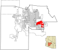
קובץ:Maricopa County Incorporated and Planning areas Mesa highlighted.svg

גודל התצוגה המקדימה הזאת מסוג PNG של קובץ ה־SVG הזה: 694 × 599 פיקסלים. רזולוציות אחרות: 278 × 240 פיקסלים | 556 × 480 פיקסלים | 889 × 768 פיקסלים | 1,185 × 1,024 פיקסלים | 2,371 × 2,048 פיקסלים | 940 × 812 פיקסלים.
לקובץ המקורי (קובץ SVG, הגודל המקורי: 940 × 812 פיקסלים, גודל הקובץ: 1.05 מ"ב)
היסטוריית הקובץ
ניתן ללחוץ על תאריך/שעה כדי לראות את הקובץ כפי שנראה באותו זמן.
| תאריך/שעה | תמונה ממוזערת | ממדים | משתמש | הערה | |
|---|---|---|---|---|---|
| נוכחית | 09:36, 20 במאי 2011 |  | 812 × 940 (1.05 מ"ב) | Ixnayonthetimmay | Uploading new version |
| 07:22, 30 באוגוסט 2008 |  | 800 × 900 (413 ק"ב) | Ixnayonthetimmay | == Summary == {{Information |Description=This map shows the incorporated areas and unincorporated areas in Maricopa County, Arizona. [[:en:Mesa, Arizona|Mesa | |
| 02:58, 16 בספטמבר 2007 |  | 800 × 900 (384 ק"ב) | Ixnayonthetimmay | ||
| 13:09, 28 במאי 2007 |  | 780 × 900 (329 ק"ב) | Ixnayonthetimmay | ||
| 03:13, 22 במאי 2007 |  | 780 × 900 (318 ק"ב) | Ixnayonthetimmay | ||
| 08:17, 30 בינואר 2007 |  | 758 × 904 (177 ק"ב) | Ixnayonthetimmay | {{Information |Description=This map shows the incorporated areas in Maricopa County, Arizona, highlighting Mesa in red. It also shows the boundaries for the municip |
שימוש בקובץ
הדפים הבאים משתמשים בקובץ הזה:
שימוש גלובלי בקובץ
אתרי הוויקי השונים הבאים משתמשים בקובץ זה:
- שימוש באתר bn.wikipedia.org
- שימוש באתר br.wikipedia.org
- שימוש באתר ceb.wikipedia.org
- שימוש באתר cs.wikipedia.org
- שימוש באתר de.wikipedia.org
- שימוש באתר et.wikipedia.org
- שימוש באתר fa.wikipedia.org
- שימוש באתר fi.wikipedia.org
- שימוש באתר hu.wikipedia.org
- שימוש באתר ja.wikipedia.org
- שימוש באתר ko.wikipedia.org
- שימוש באתר kw.wikipedia.org
- שימוש באתר pam.wikipedia.org
- שימוש באתר pt.wikipedia.org
- שימוש באתר ro.wikipedia.org
- שימוש באתר sk.wikipedia.org
- שימוש באתר sl.wikipedia.org
- שימוש באתר sv.wikipedia.org
- שימוש באתר sw.wikipedia.org
- שימוש באתר th.wikipedia.org
- שימוש באתר tr.wikipedia.org
- שימוש באתר ur.wikipedia.org
- שימוש באתר vi.wikipedia.org
- שימוש באתר zh.wikipedia.org
