
קובץ:Martinique legende arrs.PNG
אין גרסה ברזולוציה גבוהה יותר.
Martinique_legende_arrs.PNG (419 × 478 פיקסלים, גודל הקובץ: 16 ק"ב, סוג MIME: image/png)
| זהו קובץ שמקורו במיזם ויקישיתוף. תיאורו בדף תיאור הקובץ המקורי (בעברית) מוצג למטה. |
תקציר
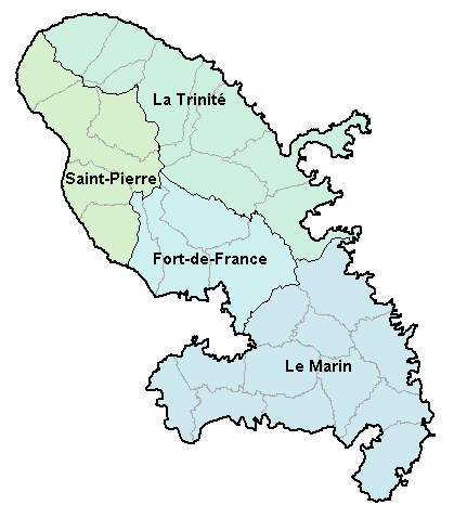
| תיאור |
Carte de la Martinique avec ses 4 arrondissements. Map of French department of Martinique with its 4 "arrondissements". |
| תאריך יצירה | 2 בינואר 2007 (תאריך העלאה מקורי) |
| מקור | לא סופק מקור מכונה קריא. ההנחה היא כי היצירה נוצרה על ידי מעלה היצירה (בהתבסס על תבנית הרישיון). |
| יוצר | לא סופק יוצר ששמו ניתן לקריאה במכונה. בהתבסס על תביעות זכויות יוצרים, ההנחה היא כי BigonL הוא היוצר. |
רישיון
| ברצוני, בעלי זכויות היוצרים על יצירה זו, לשחרר יצירה זו לנחלת הכלל. זה תקף בכל העולם. יש מדינות שבהן הדבר אינו אפשרי על פי חוק, אם כך: אני מעניק לכל אחד את הזכות להשתמש בעבודה זו לכל מטרה שהיא, ללא תנאים כלשהם, אלא אם כן תנאים כאלה נדרשים על פי חוק. |
היסטוריית הקובץ
ניתן ללחוץ על תאריך/שעה כדי לראות את הקובץ כפי שנראה באותו זמן.
| תאריך/שעה | תמונה ממוזערת | ממדים | משתמש | הערה | |
|---|---|---|---|---|---|
| נוכחית | 19:48, 2 בינואר 2007 | | 478 × 419 (16 ק"ב) | BigonL | Carte de la Martinique avec ses 4 arrondissements. Map of French department of Martinique with its 4 "arrondissements". |
שימוש בקובץ
![]() אין בוויקיפדיה דפים המשתמשים בקובץ זה.
אין בוויקיפדיה דפים המשתמשים בקובץ זה.
שימוש גלובלי בקובץ
אתרי הוויקי השונים הבאים משתמשים בקובץ זה:
- שימוש באתר cs.wikipedia.org
- שימוש באתר cv.wikipedia.org
- שימוש באתר el.wikipedia.org
- שימוש באתר en.wikipedia.org
- שימוש באתר es.wikipedia.org
- שימוש באתר fa.wikipedia.org
- שימוש באתר fr.wikipedia.org
- שימוש באתר gl.wikipedia.org
- שימוש באתר is.wikipedia.org
- שימוש באתר it.wikipedia.org
- שימוש באתר ka.wikipedia.org
- שימוש באתר lb.wikipedia.org
- שימוש באתר mk.wikipedia.org
- שימוש באתר oc.wikipedia.org
- Fort-de-France
- Comunas de Martinica
- Modèl:Comunas de Martinica
- L'Ajoupa-Bouillon
- Les Anses-d'Arlet
- Basse-Pointe
- Le Carbet
- Case-Pilote
- Le Diamant
- Ducos
- Fonds-Saint-Denis
- Le François
- Grand'Rivière
- Gros-Morne
- Le Lamentin
- Le Lorrain
- Macouba
- Le Marigot
- Le Marin
- Le Morne-Rouge
- Le Prêcheur
- Rivière-Pilote
- Rivière-Salée
- Le Robert
- Saint-Esprit
- Saint-Joseph (Martinica)
- Saint-Pierre (Martinica)
- Sainte-Luce (Martinica)
- Schœlcher
- La Trinité
- Les Trois-Îlets
- Le Vauclin
- Le Morne-Vert
- Bellefontaine (Martinica)
- Sainte-Marie (Martinica)
- Sainte-Anne (Martinica)