
קובץ:Nares strait border (Kennedy channel).png

גודל התצוגה המקדימה הזאת: 800 × 566 פיקסלים. רזולוציות אחרות: 320 × 226 פיקסלים | 640 × 453 פיקסלים | 1,024 × 725 פיקסלים | 1,280 × 906 פיקסלים | 1,765 × 1,249 פיקסלים.
לקובץ המקורי (1,765 × 1,249 פיקסלים, גודל הקובץ: 124 ק"ב, סוג MIME: image/png)
| זהו קובץ שמקורו במיזם ויקישיתוף. תיאורו בדף תיאור הקובץ המקורי (בעברית) מוצג למטה. |
.png)
.png?uselang=he)

|
יש ליצור מחדש את התמונה map הזו באמצעות גרפיקה וקטורית כדוגמת קובץ SVG. לפעולה זו מספר יתרונות, כפי שניתן לקרוא (באנגלית) בדף Commons:Media for cleanup. אם ברשותכם קובץ SVG, אנא העלו אותו. לאחר מכן, החליפו תבנית זו בתבנית
{{vector version available|שם הקובץ.svg}} |
| תיאור |
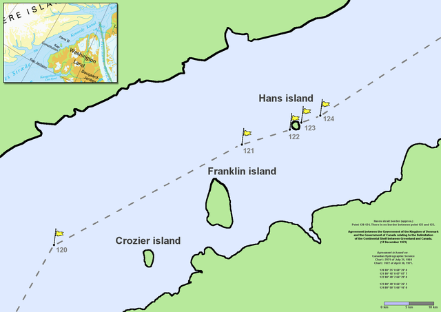
en:Nares Strait (en:Kennedy Channel) border (approx.) Point 120–124. There is no border between point 122 and 123. Agreement between the Government of the Kingdom of Denmark and the Government of Canada relating to the Delimitation of the Continental Shelf between Greenland and Canada. (17 December 1973) Agreement is based on en:Canadian Hydrographic Service charts 7071 of July 31, 1964 and 7072 of April 30, 1971
|
| תאריך יצירה | Commons upload by File Upload Bot (Magnus Manske) 10:54, 7 June 2006 (UTC) |
| מקור |
הקובץ הזה מתפרסם לפי תנאי רישיון קריאייטיב קומונז ייחוס 2.5 כללי.
|
| יוצר | User Twthmoses on en.wikipedia |
Originally from en.wikipedia; description page is (was) here
.png)
- 06:02, 29 July 2005 Twthmoses 1765x1249 (196,934 bytes) ([[:en:Nares strait]] border (approx.) Point 120-124. There is no border between point 122 and 123. ''Agreement between the Government of the Kingdom of Denmark and the Government of Canada relating to the Delimitation of the Continental Shelf between Greenla)
היסטוריית הקובץ
ניתן ללחוץ על תאריך/שעה כדי לראות את הקובץ כפי שנראה באותו זמן.
| תאריך/שעה | תמונה ממוזערת | ממדים | משתמש | הערה | |
|---|---|---|---|---|---|
| נוכחית | 13:32, 24 במרץ 2015 | | 1,249 × 1,765 (124 ק"ב) | RokerHRO | optipng -o7 -i0 → 35.36% decrease |
| 13:54, 7 ביוני 2006 |  | 1,249 × 1,765 (192 ק"ב) | File Upload Bot (Magnus Manske) | {{Information| |Description= en:Nares Strait (en:Kennedy Channel) border (approx.) Point 120-124. There is no border between point 122 and 123. ''Agreement between the Government of the Kingdom of Denmark and the Government of Canada relating |
שימוש בקובץ
הדפים הבאים משתמשים בקובץ הזה:
- האי הנס
- ויקיפדיה:הידעת?/2013/מרץ
- ויקיפדיה:הידעת?/2015/מרץ
- ויקיפדיה:הידעת?/2017/מרץ
- ויקיפדיה:הידעת?/2019/מרץ
- ויקיפדיה:הידעת?/2021/מרץ
- ויקיפדיה:הידעת?/2022/מרץ
- תבנית:הידעת? 12 במרץ 2017
- תבנית:הידעת? 5 במרץ 2019
- תבנית:הידעת? 7 במרץ - סדרה 1
- תבנית:הידעת? 7 במרץ 2013
- תבנית:הידעת? 7 במרץ 2015
- תבנית:הידעת? 7 במרץ 2021
- תבנית:הידעת? 7 במרץ 2022
- פורטל:אירופה/הידעת?/88
- פורטל:אירופה/הידעת?/קטעי הידעת?
- פורטל:היסטוריה/הידעת?/80
- פורטל:היסטוריה/הידעת?/קטעי הידעת
- פורטל:מדינות העולם/הידעת?/34
- פורטל:מדינות העולם/הידעת?/קטעי הידעת?
- פורטל:מדע המדינה/הידעת?/12
- פורטל:מדע המדינה/הידעת?/קטעי הידעת?
- פורטל:מדעי החברה/הידעת?/59
- פורטל:מדעי החברה/הידעת?/קטעי הידעת?
שימוש גלובלי בקובץ
אתרי הוויקי השונים הבאים משתמשים בקובץ זה:
- שימוש באתר ar.wikipedia.org
- שימוש באתר az.wikipedia.org
- שימוש באתר bcl.wikipedia.org
- שימוש באתר be-tarask.wikipedia.org
- שימוש באתר be.wikipedia.org
- שימוש באתר bn.wikipedia.org
- שימוש באתר ca.wikipedia.org
- שימוש באתר ceb.wikipedia.org
- שימוש באתר cs.wikipedia.org
- שימוש באתר da.wikipedia.org
- שימוש באתר de.wikipedia.org
- שימוש באתר en.wikipedia.org
- שימוש באתר en.wikiversity.org
- שימוש באתר eo.wikipedia.org
- שימוש באתר es.wikipedia.org
- שימוש באתר et.wikipedia.org
- שימוש באתר fa.wikipedia.org
- שימוש באתר fr.wikipedia.org
- שימוש באתר fy.wikipedia.org
- שימוש באתר hu.wikipedia.org
- שימוש באתר id.wikipedia.org
- שימוש באתר it.wikipedia.org
.png)
.png)