
קובץ:National-atlas-rhode-island.png
אין גרסה ברזולוציה גבוהה יותר.
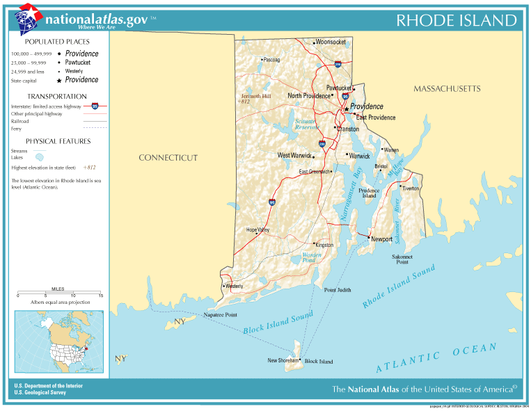
National-atlas-rhode-island.png (763 × 591 פיקסלים, גודל הקובץ: 74 ק"ב, סוג MIME: image/png)
| זהו קובץ שמקורו במיזם ויקישיתוף. תיאורו בדף תיאור הקובץ המקורי (בעברית) מוצג למטה. |
תקציר
הועבר מ- en.wikipedia לוויקישיתוףעל ידי Maksim.
תיאור הקובץ המקורי נמצא כאן. כל שמות המשתמשים הבאים מתייחסים ל-en.wikipedia.
רישיון
This map was obtained from an edition of the National Atlas of the United States. Like almost all works of the U.S. federal government, works from the National Atlas are in the public domain in the United States.
Online access: NationalAtlas.gov | 1970 print edition: Library of Congress, Perry-Castañeda Library
|
| date/time | username | edit summary |
|---|---|---|
| 22:27, 30 November 2004 | en:User:Jengod | |
| 20:31, 4 November 2004 | en:User:Jengod | ({{PD-USGov}} <a href="/wiki/Category:Rhode_Island_maps" title="Category:Rhode Island maps">Category:Rhode Island maps</a>) |
יומן העלאה מקורי
Legend: (cur) = this is the current file, (del) = delete this old version, (rev) = revert to this old version.
Click on date to download the file or see the image uploaded on that date.
- (del) (cur) 11:32, 13 December 2004 . . en:User:Berkut Berkut ( en:User_talk:Berkut Talk) . . 763x591 (75354 bytes) (reduced file size)
- (del) (rev) 20:31, 4 November 2004 . . en:User:Jengod Jengod ( en:User_talk:Jengod Talk) . . 763x591 (189814 bytes) ({ { PD-USGov } } en:Category:Rhode_Island_maps Category:Rhode Island maps)
היסטוריית הקובץ
ניתן ללחוץ על תאריך/שעה כדי לראות את הקובץ כפי שנראה באותו זמן.
| תאריך/שעה | תמונה ממוזערת | ממדים | משתמש | הערה | |
|---|---|---|---|---|---|
| נוכחית | 14:31, 28 בינואר 2006 | | 591 × 763 (74 ק"ב) | Maksim | La bildo estas kopiita de wikipedia:en. La originala priskribo estas: {{PD-USGov-Atlas}} Category:Rhode Island maps {| border="1" ! date/time || username || edit summary |---- | 22:27, 30 November 2004 || en:User:Jengod || <nowiki></nowiki> |-- |
שימוש בקובץ
![]() אין בוויקיפדיה דפים המשתמשים בקובץ זה.
אין בוויקיפדיה דפים המשתמשים בקובץ זה.
שימוש גלובלי בקובץ
אתרי הוויקי השונים הבאים משתמשים בקובץ זה:
- שימוש באתר af.wikipedia.org
- שימוש באתר ca.wikipedia.org
- שימוש באתר da.wikipedia.org
- שימוש באתר en.wikipedia.org
- שימוש באתר eo.wikipedia.org
- שימוש באתר fr.wikipedia.org
- שימוש באתר incubator.wikimedia.org
- שימוש באתר is.wikipedia.org
- שימוש באתר it.wikipedia.org
- שימוש באתר ja.wikipedia.org
- שימוש באתר kn.wikipedia.org
- שימוש באתר lb.wikipedia.org
- שימוש באתר nds-nl.wikipedia.org
- שימוש באתר nl.wikipedia.org
- שימוש באתר nn.wikipedia.org
- שימוש באתר pl.wikipedia.org
- שימוש באתר pt.wikipedia.org
- שימוש באתר sh.wikipedia.org
- שימוש באתר ur.wikipedia.org