
קובץ:StreptopeliaTurturIUCN.png

גודל התצוגה המקדימה הזאת: 800 × 566 פיקסלים. רזולוציות אחרות: 320 × 226 פיקסלים | 640 × 453 פיקסלים | 1,024 × 724 פיקסלים | 1,280 × 905 פיקסלים | 2,560 × 1,810 פיקסלים | 3,507 × 2,480 פיקסלים.
לקובץ המקורי (3,507 × 2,480 פיקסלים, גודל הקובץ: 1.06 מ"ב, סוג MIME: image/png)
| זהו קובץ שמקורו במיזם ויקישיתוף. תיאורו בדף תיאור הקובץ המקורי (בעברית) מוצג למטה. |
תקציר
| תיאור |
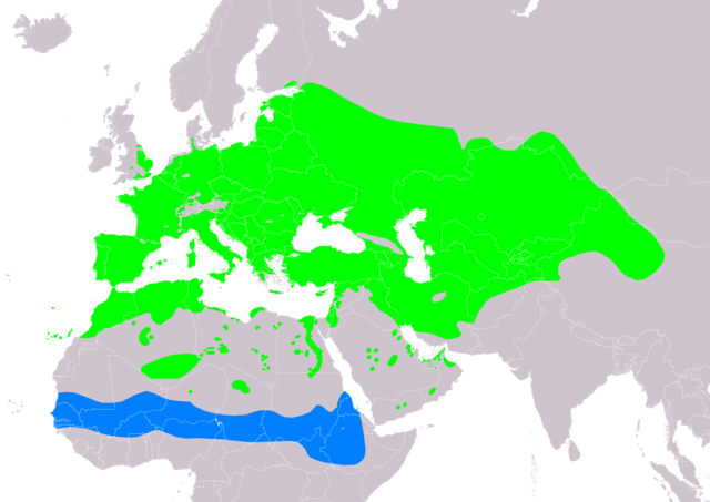
Slovenčina: Mapa rozšírenia druhu hrdlička poľná (Streptopelia turtur) podľa IUCN verzia 2020.1 (zostavil: BirdLife International and Handbook of the Birds of the World (2019) 2019.):
legenda: Hniezdiaca, výskyt v letnom období (#00FF00), Nehniezdiaca (#007FFF) English: Distribution map of european turtle-dove (Streptopelia turtur) according to IUCN version 2020.1 (compiled by: BirdLife International and Handbook of the Birds of the World (2019) 2019.); key: Legend: Extant, breeding (#00FF00), Extant, non-breeding (#007FFF) |
| תאריך יצירה | |
| מקור | Made with Natural Earth. Free vector and raster map data @ naturalearthdata.com. Range map from BirdLife International. 2019. Streptopelia turtur. The IUCN Red List of Threatened Species 2019: e.T22690419A154373407. https://dx.doi.org/10.2305/IUCN.UK.2019-3.RLTS.T22690419A154373407.en. Downloaded on 24 May 2020 as visual indicator of distribution. |
| יוצר | SanoAK: Alexander Kürthy |
רישיון

הקובץ הזה מתפרסם לפי תנאי רישיון קריאייטיב קומונז ייחוס-שיתוף זהה 3.0 לא מותאם.
ייחוס: IUCN Red List of Threatened Species, species assessors and the authors of the spatial data.
- הנכם רשאים:
- לשתף – להעתיק, להפיץ ולהעביר את העבודה
- לערבב בין עבודות – להתאים את העבודה
- תחת התנאים הבאים:
- ייחוס – יש לתת ייחוס הולם, לתת קישור לרישיון, ולציין אם נעשו שינויים. אפשר לעשות את זה בכל צורה סבירה, אבל לא בשום צורה שמשתמע ממנה שמעניק הרישיון תומך בך או בשימוש שלך.
- שיתוף זהה – אם תיצרו רמיקס, תשנו, או תבנו על החומר, חובה עליכם להפיץ את התרומות שלך לפי תנאי רישיון זהה או תואם למקור.
היסטוריית הקובץ
ניתן ללחוץ על תאריך/שעה כדי לראות את הקובץ כפי שנראה באותו זמן.
| תאריך/שעה | תמונה ממוזערת | ממדים | משתמש | הערה | |
|---|---|---|---|---|---|
| נוכחית | 02:20, 22 בנובמבר 2021 | | 2,480 × 3,507 (1.06 מ"ב) | MPF | cleanup |
| 02:13, 22 בנובמבר 2021 |  | 2,480 × 3,507 (1.08 מ"ב) | MPF | Update European distribution per EBBA2 Atlas (2020) | |
| 13:00, 24 במאי 2020 |  | 2,480 × 3,507 (1.16 מ"ב) | SanoAK | Uploaded a work by SanoAK: Alexander Kürthy from Made with Natural Earth. Free vector and raster map data @ naturalearthdata.com. Range map from BirdLife International. 2019. Streptopelia turtur. The IUCN Red List of Threatened Species 2019: e.T22690419A154373407. https://dx.doi.org/10.2305/IUCN.UK.2019-3.RLTS.T22690419A154373407.en. Downloaded on 24 May 2020 as visual indicator of distribution. with UploadWizard |
שימוש בקובץ
הדף הבא משתמש בקובץ הזה:
שימוש גלובלי בקובץ
אתרי הוויקי השונים הבאים משתמשים בקובץ זה:
- שימוש באתר af.wikipedia.org
- שימוש באתר an.wikipedia.org
- שימוש באתר ar.wikipedia.org
- שימוש באתר arz.wikipedia.org
- שימוש באתר ast.wikipedia.org
- שימוש באתר bg.wikipedia.org
- שימוש באתר ca.wikipedia.org
- שימוש באתר cs.wikipedia.org
- שימוש באתר da.wikipedia.org
- שימוש באתר de.wikipedia.org
- שימוש באתר en.wikipedia.org
- שימוש באתר eo.wikipedia.org
- שימוש באתר es.wikipedia.org
- שימוש באתר eu.wikipedia.org
- שימוש באתר fi.wikipedia.org
- שימוש באתר fr.wikipedia.org
- שימוש באתר fy.wikipedia.org
- שימוש באתר ga.wikipedia.org
- שימוש באתר hr.wikipedia.org
- שימוש באתר hu.wikipedia.org
- שימוש באתר hy.wikipedia.org
- שימוש באתר id.wikipedia.org
- שימוש באתר io.wikipedia.org
- שימוש באתר lb.wikipedia.org
- שימוש באתר lt.wikipedia.org
- שימוש באתר nl.wikipedia.org
- שימוש באתר nn.wikipedia.org
- שימוש באתר no.wikipedia.org
- שימוש באתר pl.wikipedia.org
- שימוש באתר pt.wikipedia.org
- שימוש באתר ru.wikipedia.org
- שימוש באתר sk.wikipedia.org
- שימוש באתר species.wikimedia.org
- שימוש באתר sv.wikipedia.org
- שימוש באתר tg.wikipedia.org
- שימוש באתר uk.wikipedia.org
- שימוש באתר www.wikidata.org
- שימוש באתר zh.wikipedia.org