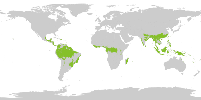
קובץ:Tropical wet forests.svg
תוכן הדף אינו נתמך בשפות אחרות.
מתוך ויקיפדיה, האנציקלופדיה החופשית

לקובץ המקורי(קובץ SVG, הגודל המקורי: 1,052 × 523 פיקסלים, גודל הקובץ: 7.7 מ"ב)

ויקישיתוף זהו קובץ שמקורו במיזם ויקישיתוף. תיאורו בדף תיאור הקובץ המקורי (בעברית) מוצג למטה.

תקציר

תיאור
English: Tropical wet forests. The humid tropical biome was delineated using the World Wildlife Fund terrestrial ecoregions map. This map was modified to exclude mountain and coastal forest mosaic ecoregions in Africa.
Français : Forêts tropicales humides.
תאריך יצירה
מקור נוצר על־ידי מעלה היצירה
יוצר Yerachmiel C
 
QGIS עם‎‎ נוצרה ה תמונה

רישיון

אני, בעל זכויות היוצרים על עבודה זו, מפרסם בזאת את העבודה תחת הרישיון הבא:
w:he:Creative Commons
ייחוס שיתוף זהה
הקובץ הזה מתפרסם לפי תנאי רישיון קריאייטיב קומונז ייחוס-שיתוף זהה 4.0 בין־לאומי.
הנכם רשאים:
  • לשתף – להעתיק, להפיץ ולהעביר את העבודה
  • לערבב בין עבודות – להתאים את העבודה
תחת התנאים הבאים:
  • ייחוס – יש לתת ייחוס הולם, לתת קישור לרישיון, ולציין אם נעשו שינויים. אפשר לעשות את זה בכל צורה סבירה, אבל לא בשום צורה שמשתמע ממנה שמעניק הרישיון תומך בך או בשימוש שלך.
  • שיתוף זהה – אם תיצרו רמיקס, תשנו, או תבנו על החומר, חובה עליכם להפיץ את התרומות שלך לפי תנאי רישיון זהה או תואם למקור.


Map uses following sources:

"Biome boundary. The humid tropical biome was delineated using the World Wildlife Fund terrestrial ecoregions map. This map was modified to exclude mountain and coastal forest mosaic ecoregions in Africa." on Global Forest Monitoring Project

Original data licensed as:

"Provided data are available for use for valid scientific, conservation, and educational purposes as long as proper citations are used. We ask that you credit the Humid Tropical Monitoring data as follows: Hansen, M.C., Stehman, S.V., Potapov, P.V., Loveland, T.R., Townshend, J.R.G., DeFries, R.S., Pittman, K.W., Stolle, F., Steininger, M.K., Carroll, M., Dimiceli, C. (2008) Humid tropical forest clearing from 2000 to 2005 quantified using multi-temporal and multi-resolution remotely sensed data. PNAS, 105(27), 9439-9444."

Shapefile of forests:

  • By Geographic Information Science Center of Excellence (GIScCE) - SDSU [1] ;

World map with national country outlines and border:

כיתובים

נא להוסיף משפט שמסביר מה הקובץ מייצג

פריטים שמוצגים בקובץ הזה

מוצג

ערך כלשהו ללא פריט ויקינתונים

image/svg+xml

היסטוריית הקובץ

ניתן ללחוץ על תאריך/שעה כדי לראות את הקובץ כפי שנראה באותו זמן.

תאריך/שעהתמונה ממוזערתממדיםמשתמשהערה
נוכחית19:20, 27 באוגוסט 2022תמונה ממוזערת לגרסה מ־19:20, 27 באוגוסט 2022‪523 × 1,052‬ (7.7 מ"ב)Yerachmiel Creduce stroke around country borders
19:10, 27 באוגוסט 2022תמונה ממוזערת לגרסה מ־19:10, 27 באוגוסט 2022‪523 × 1,052‬ (7.76 מ"ב)Yerachmiel Cfix
18:17, 27 באוגוסט 2022תמונה ממוזערת לגרסה מ־18:17, 27 באוגוסט 2022‪523 × 1,052‬ (7.9 מ"ב)Yerachmiel CUploaded own work with UploadWizard

הדף הבא משתמש בקובץ הזה:

שימוש גלובלי בקובץ

אתרי הוויקי השונים הבאים משתמשים בקובץ זה:

מטא־נתונים