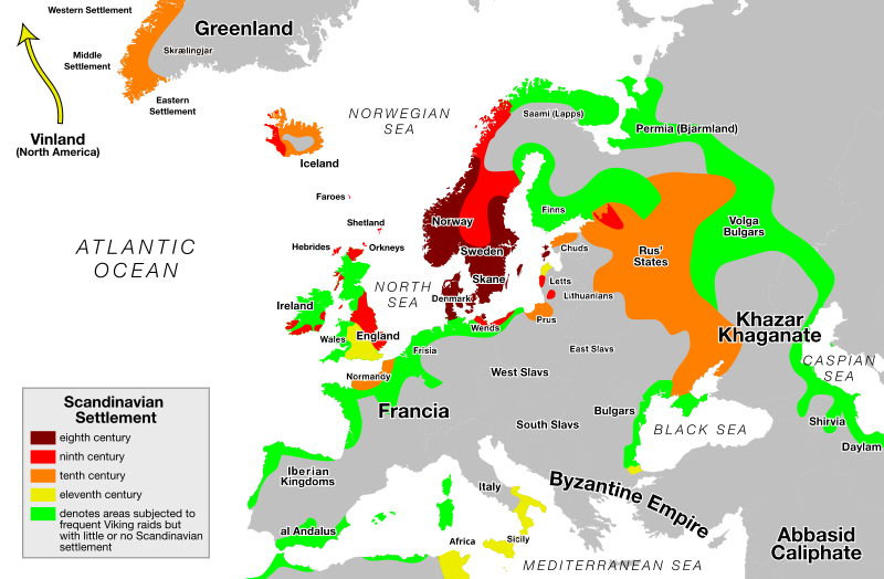
קובץ:Viking Expansion.svg

גודל התצוגה המקדימה הזאת מסוג PNG של קובץ ה־SVG הזה: 800 × 524 פיקסלים. רזולוציות אחרות: 320 × 210 פיקסלים | 640 × 419 פיקסלים | 1,024 × 671 פיקסלים | 1,280 × 838 פיקסלים | 2,560 × 1,677 פיקסלים.
לקובץ המקורי (קובץ SVG, הגודל המקורי: 800 × 524 פיקסלים, גודל הקובץ: 2.92 מ"ב)
היסטוריית הקובץ
ניתן ללחוץ על תאריך/שעה כדי לראות את הקובץ כפי שנראה באותו זמן.
| תאריך/שעה | תמונה ממוזערת | ממדים | משתמש | הערה | |
|---|---|---|---|---|---|
| נוכחית | 01:29, 26 בפברואר 2018 |  | 524 × 800 (2.92 מ"ב) | Asmodim | Added the areas of the Norman "Kingdom of Africa" (see article on wikipedia), conquest part of the Norman kingdom of Sicily under Roger II. |
| 22:16, 15 באוגוסט 2015 |  | 524 × 800 (1.4 מ"ב) | Ras67 | frame removed | |
| 12:24, 21 במאי 2015 |  | 521 × 793 (1.39 מ"ב) | Wereldburger758 | Removal modern state borders. Valid SVG now. | |
| 14:08, 3 בדצמבר 2012 |  | 521 × 793 (1.93 מ"ב) | OjdvQ9fNJWl | Fixed colors | |
| 13:43, 3 בדצמבר 2012 |  | 521 × 793 (1.93 מ"ב) | OjdvQ9fNJWl | Updated 11th century areas. Added Bari and Apulia in Italy, and renamed Spanish Kingdoms to Iberian Kingdoms. | |
| 23:38, 24 ביוני 2007 |  | 521 × 793 (1.9 מ"ב) | Max Naylor~commonswiki | == Summary == {{Information |Description=An SVG version of this image. Created with Adobe Illustrator CS3. Based on the blank Europe map available on the Commons. The enclosed legend is as follows: {{legend|#800000|eighth c | |
| 23:25, 24 ביוני 2007 |  | 521 × 793 (1.25 מ"ב) | Max Naylor~commonswiki | == Summary == {{Information |Description=An SVG version of this image. Created with Adobe Illustrator CS3. Based on the blank Europe map available on the Commons. The enclosed legend is as follows: {{legend|#800000|eighth c | |
| 23:20, 24 ביוני 2007 |  | 521 × 793 (1.26 מ"ב) | Max Naylor~commonswiki | == Summary == {{Information |Description=An SVG version of this image. Created with Adobe Illustrator CS3. Based on the blank Europe map available on the Commons. The enclosed legend is as follows: {{legend|#800000|eighth c | |
| 23:18, 24 ביוני 2007 |  | 521 × 793 (1.26 מ"ב) | Max Naylor~commonswiki | == Summary == {{Information |Description=An SVG version of this image. Created with Adobe Illustrator CS3. Based on the blank Europe map available on the Commons. The enclosed legend is as follows: {{legend|#800000|eighth c | |
| 23:16, 24 ביוני 2007 | 682 × 2,443 (1.26 מ"ב) | Max Naylor~commonswiki | {{Information |Description=An SVG version of this image. Created with Adobe Illustrator CS3. Based on the blank Europe map available on the Commons. The enclosed legend is as follows: {{legend|#800000|eighth centuries}} {{l |
שימוש בקובץ
הדפים הבאים משתמשים בקובץ הזה:
שימוש גלובלי בקובץ
אתרי הוויקי השונים הבאים משתמשים בקובץ זה:
- שימוש באתר af.wikipedia.org
- שימוש באתר an.wikipedia.org
- שימוש באתר ar.wikipedia.org
- שימוש באתר arz.wikipedia.org
- שימוש באתר ast.wikipedia.org
- שימוש באתר az.wikipedia.org
- שימוש באתר be.wikipedia.org
- שימוש באתר bg.wikipedia.org
- שימוש באתר bn.wikipedia.org
- שימוש באתר bs.wikipedia.org
- שימוש באתר ca.wikipedia.org
- שימוש באתר cs.wikipedia.org
- שימוש באתר cy.wikipedia.org
- שימוש באתר da.wikipedia.org
- Nordisk mytologi
- Vikinger
- Vikingetid
- Nordisk religion
- Kristendommens indførelse i Danmark
- Nordboere
- Portal:Historie/Udvalgt artikel/2017
- Vikingernes ekspansion
- Wikipedia:Wikipediajournalen/Arkiv/juli 2017/Artikeludnævnelser
- Portal:Historie/Udvalgt artikel/september, 2017
- Wikipedia:Ugens artikel/2022
- Wikipedia:Ugens artikel/Uge 18, 2022
- שימוש באתר de.wikipedia.org
- שימוש באתר dsb.wikipedia.org
- שימוש באתר el.wikipedia.org
- שימוש באתר en.wikipedia.org


