
קובץ:CIRCASSIA1840.jpg
לקובץ המקורי (6,348 × 3,047 פיקסלים, גודל הקובץ: 544 ק"ב, סוג MIME: image/jpeg)
| זהו קובץ שמקורו במיזם ויקישיתוף. תיאורו בדף תיאור הקובץ המקורי (בעברית) מוצג למטה. |
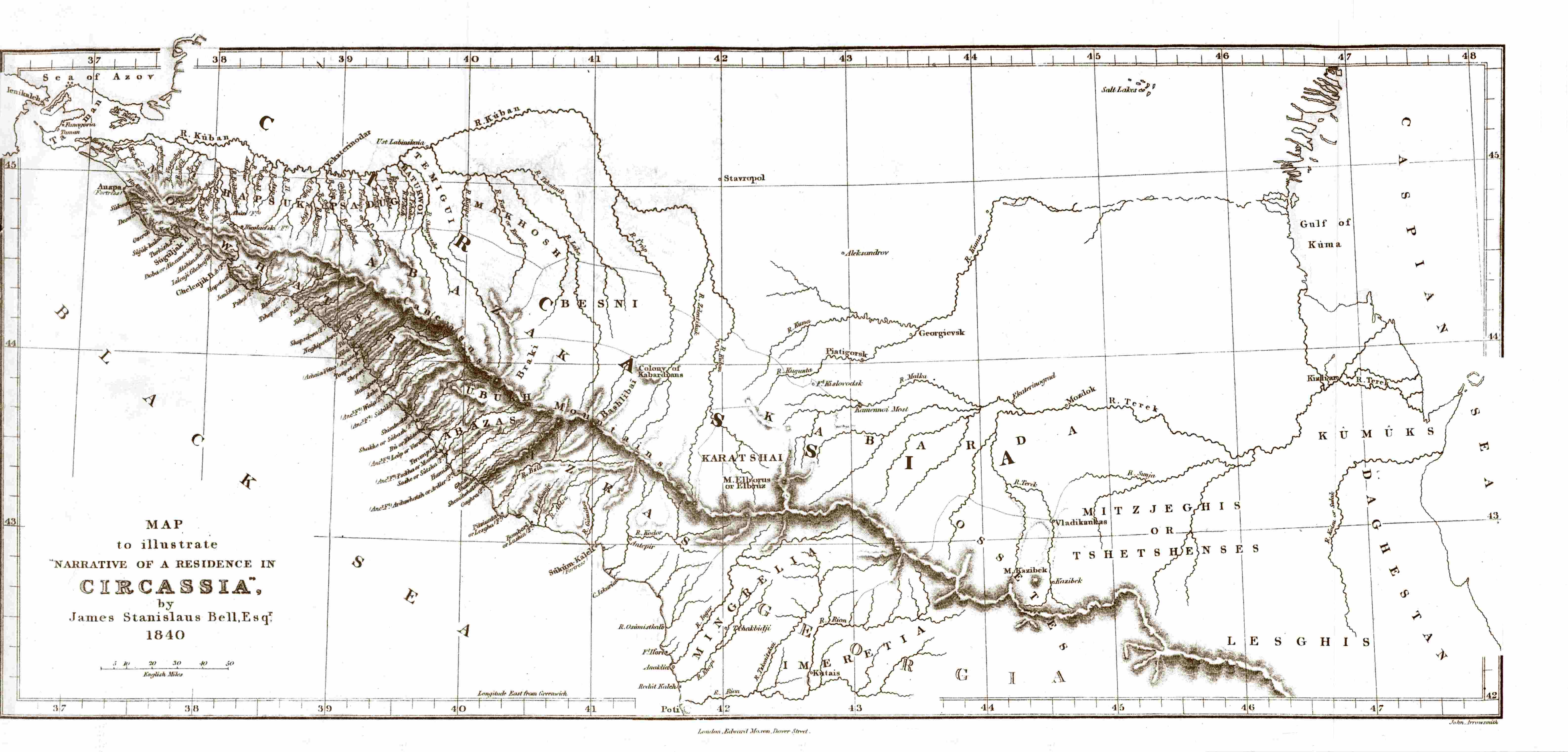
| תיאור | Map of Circassia, made in 1840 during the en:Russian-Circassian War, PD due to author's death over 100 years ago. Found here, lon. 36.5° - 48° E, lat. 42° - 45.5° N | ||||
| תאריך יצירה | 5 במאי 2007 (תאריך העלאה מקורי) | ||||
| מקור | הועבר מ- en.wikipedia לוויקישיתוף. | ||||
| יוצר |
James Stanislaus Bell (1797-1858) |
||||
| אישורים והיתרים (שימוש חוזר בקובץ זה) |
|
||||
יומן העלאה מקורי
- 2007-05-05 20:44 SGGH 6348×3047×8 (556561 bytes) Map of Circassia, made in 1840 during the [[Russian-Circassian War]], PD due to author's death over 100 years ago. Found [http://www.circassianworld.com/CIRCASSIA1840.jpg here]
היסטוריית הקובץ
ניתן ללחוץ על תאריך/שעה כדי לראות את הקובץ כפי שנראה באותו זמן.
| תאריך/שעה | תמונה ממוזערת | ממדים | משתמש | הערה | |
|---|---|---|---|---|---|
| נוכחית | 22:49, 2 בינואר 2014 | | 3,047 × 6,348 (544 ק"ב) | Don-kun | Reverted Vandalism; this is an original map which cannot be replaced by some totally different map |
| 19:08, 20 באוקטובר 2013 |  | 528 × 768 (71 ק"ב) | Руслан Шаов | Черкесия.1700 года | |
| 12:43, 8 ביולי 2007 |  | 3,047 × 6,348 (544 ק"ב) | Hardscarf | {{Information |Description=Map of Circassia, made in 1840 during the en:Russian-Circassian War, PD due to author's death over 100 years ago. Found [http://www.circassianworld.com/CIRCASSIA1840.jpg here] |Source=Originally from [http://en.wikipedia.or |
שימוש בקובץ
הדף הבא משתמש בקובץ הזה:
שימוש גלובלי בקובץ
אתרי הוויקי השונים הבאים משתמשים בקובץ זה:
- שימוש באתר ar.wikipedia.org
- שימוש באתר av.wikipedia.org
- שימוש באתר azb.wikipedia.org
- שימוש באתר ba.wikipedia.org
- שימוש באתר br.wikipedia.org
- שימוש באתר de.wikipedia.org
- שימוש באתר en.wikipedia.org
- שימוש באתר es.wikipedia.org
- שימוש באתר fi.wikipedia.org
- שימוש באתר fr.wikipedia.org
- שימוש באתר hu.wikipedia.org
- שימוש באתר it.wikipedia.org
- שימוש באתר ka.wikipedia.org
- שימוש באתר kbd.wikipedia.org
- שימוש באתר lt.wikipedia.org
- שימוש באתר nl.wikipedia.org
- שימוש באתר pl.wikipedia.org
- שימוש באתר pnb.wikipedia.org
- שימוש באתר ro.wikipedia.org
- שימוש באתר ru.wikipedia.org
- שימוש באתר sl.wikipedia.org
- שימוש באתר tr.wikipedia.org
- שימוש באתר uk.wikipedia.org
- שימוש באתר ur.wikipedia.org