קובץ:Empire of Theodoric the Great 523.gif

תוכן הדף אינו נתמך בשפות אחרות.
מתוך ויקיפדיה, האנציקלופדיה החופשית

Empire_of_Theodoric_the_Great_523.gif(523 × 478 פיקסלים, גודל הקובץ: 33 ק"ב, סוג MIME‏: image/gif)

ויקישיתוף זהו קובץ שמקורו במיזם ויקישיתוף. תיאורו בדף תיאור הקובץ המקורי (בעברית) מוצג למטה.

תקציר

תיאור
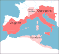
English: Map of the territories (pink) ruled by Theodoric the Great at their height in 523, when he annexed the southern part of the Burgundian kingdom, between the rivers Durance and Isere. Stippled areas indicate other kingdoms dominated by Theodoric at this time.
תאריך יצירה
מקור prepared from information in Wikipedia, Historical Atlases, and other books,in particular The Goths by Peter Heather
יוצר Howard Wiseman
גרסאות אחרות based on a map at http://www.sci.gu.edu.au/~wiseman/Roman/5CompMaps.html

רישיון

Vortimer מוויקיפדיה האנגלית, בעל זכויות היוצרים על היצירה הזאת, מפרסם אותה בזאת תחת הרישיונות הבאים:
GNU head מוענקת בכך הרשות להעתיק, להפיץ או לשנות את המסמך הזה, לפי תנאי הרישיון לשימוש חופשי במסמכים של גנו, גרסה 1.2 או כל גרסה מאוחרת יותר שתפורסם על־ידי המוסד לתוכנה חופשית; ללא פרקים קבועים, ללא טקסט עטיפה קדמית וללא טקסט עטיפה אחורית. עותק של הרישיון כלול בפרק שכותרתו הרישיון לשימוש חופשי במסמכים של גנו.
w:he:Creative Commons
ייחוס
הקובץ הזה מתפרסם לפי תנאי רישיון קריאייטיב קומונז ייחוס 3.0 לא מותאם.
הנכם רשאים:
  • לשתף – להעתיק, להפיץ ולהעביר את העבודה
  • לערבב בין עבודות – להתאים את העבודה
תחת התנאים הבאים:
  • ייחוס – יש לתת ייחוס הולם, לתת קישור לרישיון, ולציין אם נעשו שינויים. אפשר לעשות את זה בכל צורה סבירה, אבל לא בשום צורה שמשתמע ממנה שמעניק הרישיון תומך בך או בשימוש שלך.
הנכם מוזמנים לבחור את הרישיון הרצוי בעיניכם.

יומן העלאה מקורי

הועבר מ- en.wikipedia לוויקישיתוףעל ידי Lazyhawk באמצעות CommonsHelper.

תיאור הקובץ המקורי נמצא כאן. כל שמות המשתמשים הבאים מתייחסים ל-en.wikipedia.
  • 2007-12-28 04:23 Vortimer 523×478× (33298 bytes) {{Information |Description=Map of the territories (pink) ruled by Theodoric the Great at their height in 523, when he annexed the souther part of the Burgundian kingdom, between the rivers Durance and Isere. Stippled areas indicate other kin
  • 2007-12-27 12:01 Vortimer 523×478× (33484 bytes) {{Information |Description=Map of the territories (pink) ruled by Theodoric the Great at their height in 523, when he annexed the souther part of the Burgundian kingdom, between the rivers Durance and Isere. Stippled areas indicate other kingdoms dominate
  • 2007-12-27 11:57 Vortimer 523×478× (32320 bytes) {{Information |Description=Map of the territories (pink) ruled by Theodoric the Great at their height in 523, when he annexed the souther part of the Burgundian kingdom, between the rivers Durance and Isere. Stippled areas indicate other kingdoms dominate

כיתובים

נא להוסיף משפט שמסביר מה הקובץ מייצג

פריטים שמוצגים בקובץ הזה

מוצג

היסטוריית הקובץ

ניתן ללחוץ על תאריך/שעה כדי לראות את הקובץ כפי שנראה באותו זמן.

תאריך/שעהתמונה ממוזערתממדיםמשתמשהערה
נוכחית16:15, 20 בדצמבר 2011תמונה ממוזערת לגרסה מ־16:15, 20 בדצמבר 2011‪478 × 523‬ (33 ק"ב)OgreBot(BOT): Reverting to most recent version before archival
16:15, 20 בדצמבר 2011תמונה ממוזערת לגרסה מ־16:15, 20 בדצמבר 2011‪478 × 523‬ (33 ק"ב)OgreBot(BOT): Uploading old version of file from en.wikipedia; originally uploaded on 2007-12-27 12:01:51 by Vortimer
16:15, 20 בדצמבר 2011תמונה ממוזערת לגרסה מ־16:15, 20 בדצמבר 2011‪478 × 523‬ (32 ק"ב)OgreBot(BOT): Uploading old version of file from en.wikipedia; originally uploaded on 2007-12-27 11:57:01 by Vortimer
04:55, 12 בספטמבר 2011תמונה ממוזערת לגרסה מ־04:55, 12 בספטמבר 2011‪478 × 523‬ (33 ק"ב)File Upload Bot (Magnus Manske) {{BotMoveToCommons|en.wikipedia|year={{subst:CURRENTYEAR}}|month={{subst:CURRENTMONTHNAME}}|day={{subst:CURRENTDAY}}}} {{Information |Description={{en|Map of the territories (pink) ruled by Theodoric the Great at their height in 523, when he annexed the

הדף הבא משתמש בקובץ הזה:

שימוש גלובלי בקובץ

אתרי הוויקי השונים הבאים משתמשים בקובץ זה: