קובץ:Floridakeys-nasa.jpg
תוכן הדף אינו נתמך בשפות אחרות.
מתוך ויקיפדיה, האנציקלופדיה החופשית

לקובץ המקורי(1,400 × 1,000 פיקסלים, גודל הקובץ: 215 ק"ב, סוג MIME‏: image/jpeg)

ויקישיתוף זהו קובץ שמקורו במיזם ויקישיתוף. תיאורו בדף תיאור הקובץ המקורי (בעברית) מוצג למטה.

תקציר

תיאור
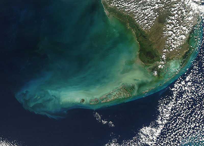
English: Turbid waters surround southern Florida and the Florida Keys in this true-color Moderate Resolution Imaging Spectroradiometer (MODIS) image taken by the Aqua satellite on December 2, 2003. Clouds of milky blue, green, and tan sediments and microscopic marine organisms (like phytoplankton and algae) discolor the water in the Gulf of Mexico north of the Keys, but end abruptly in the deeper water of the Straits of Florida. The water north of the Keys is relatively shallow, so sediments are a likely cause of the discoloration—rough waters can churn up the mud from the sea floor, which then clouds the water. But in the deeper water south of the Keys, sediment on the sea floor is much harder to disturb, which keeps the water clearer.

The Keys are a collection of islands, islets, and reefs stretching from Virginia Key to the Dry Tortugas, a distance of about 309 kilometers (192 miles). They're made mostly of limestone and coral, and are known for their variety of wildlife, subtropical vegetation, and spectacular diving. Most of the islands are connected to the mainland via the Overseas Highway, making this a popular and easily-accessible destination.

However, popularity can be a double-edged sword. On the one hand, tourism is one of the economic mainstays of the region, and helps increase public awareness of how fragile this ecosystem is. But on the other hand, those same tourists and their activities can hurt the ecosystem by introducing pollutants and causing physical damage to fragile reefs.
תאריך יצירה
מקור www.nasa.gov
יוצר Jeff Schmaltz, MODIS Rapid Response Team, NASA/GSFC

רישיון

Public domain קובץ זה נמצא ברשות הציבור מכיוון שהוא נוצר על ידי נאס"א. מדיניות זכויות היוצרים של נאס"א קובעת ש"חומרים של NASA אינם מוגנים בזכויות יוצרים אלא אם צוין אחרת". (דף מדיניות זכויות היוצרים ב-NASA או מדיניות שימוש בתמונות ב-JPL).
אזהרות:
  • שימוש בלוגואים, סמלים וטלאים של נאס"א כפוף להגבלה של החוק בארצות הברית 14 CFR 1221.
  • אתר האינטרנט של נאס"א מכיל תמונות רבות שמקורן מתוכנית החלל הסובייטית/סוכנות החלל הרוסית, וחומרים נוספים של סוכנויות חלל אחרות. קבצים אלו אינם בהכרח תחת רשות הציבור.
  • חומרים מטלסקופ החלל האבל עשויים להיות מוגנים בזכויות יוצרים אם לא מצוין במפורש שהגיעו מSTScI. [1]
  • כל החומרים שנוצרו על ידי חללית SOHO מוגנים בזכויות יוצרים ודורשים הרשאה עבור שימוש מסחרי לא חינוכי. [2]
  • תמונות המוצגות באתר Astronomy Picture of the Day (APOD) עשויים להיות מוגנים בזכויות יוצרים. [3]

כיתובים

נא להוסיף משפט שמסביר מה הקובץ מייצג

פריטים שמוצגים בקובץ הזה

מוצג

היסטוריית הקובץ

ניתן ללחוץ על תאריך/שעה כדי לראות את הקובץ כפי שנראה באותו זמן.

תאריך/שעהתמונה ממוזערתממדיםמשתמשהערה
נוכחית00:59, 24 באוגוסט 2005תמונה ממוזערת לגרסה מ־00:59, 24 באוגוסט 2005‪1,000 × 1,400‬ (215 ק"ב)Nanosmile * Credit Jeff Schmaltz, MODIS Rapid Response Team, NASA/GSFC Turbid waters surround southern Florida and the Florida Keys in this true-color Moderate Resolution Imaging Spectroradiometer (MODIS) image taken by the Aqua satellite on Dece

הדף הבא משתמש בקובץ הזה:

שימוש גלובלי בקובץ

אתרי הוויקי השונים הבאים משתמשים בקובץ זה:

מטא־נתונים