
קובץ:Lidar P1270901.jpg

גודל התצוגה המקדימה הזאת: 450 × 600 פיקסלים. רזולוציות אחרות: 180 × 240 פיקסלים | 360 × 480 פיקסלים | 576 × 768 פיקסלים | 768 × 1,024 פיקסלים | 1,920 × 2,560 פיקסלים.
לקובץ המקורי (1,920 × 2,560 פיקסלים, גודל הקובץ: 1.71 מ"ב, סוג MIME: image/jpeg)
| זהו קובץ שמקורו במיזם ויקישיתוף. תיאורו בדף תיאור הקובץ המקורי (בעברית) מוצג למטה. |
תקציר
| תיאור |
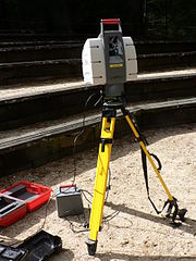
English: This Leica terrestrial lidar (light detection and ranging) scanner (TLS) may be used to scan buildings, rock formations, etc., to produce a 3D model.
The TLS can aim its laser beam in a wide range: its head rotates horizontally, a miror flips vertically. The laser beam is used to measure the distance to the first object on its path. Model: Leica HDS-3000 The Lidar was being demonstrated at UC Santa Cruz when the photo was taken. |
| תאריך יצירה | 28 בפברואר 2007 (על פי נתוני ה-Exif) |
| מקור | נוצר על־ידי מעלה היצירה |
| יוצר | David Monniaux |
רישיון
אני, בעל זכויות היוצרים על היצירה הזאת, מפרסם אותה בזאת תחת הרישיונות הבאים:

|
מוענקת בכך הרשות להעתיק, להפיץ או לשנות את המסמך הזה, לפי תנאי הרישיון לשימוש חופשי במסמכים של גנו, גרסה 1.2 או כל גרסה מאוחרת יותר שתפורסם על־ידי המוסד לתוכנה חופשית; ללא פרקים קבועים, ללא טקסט עטיפה קדמית וללא טקסט עטיפה אחורית. עותק של הרישיון כלול בפרק שכותרתו הרישיון לשימוש חופשי במסמכים של גנו. |
| הקובץ הזה מתפרסם לפי תנאי רישיון קריאייטיב קומונז ייחוס-שיתוף זהה 3.0 לא מותאם. | ||
| ||
| תבנית רישוי זו הוספה לקובץ כחלק מעדכון רישיון GFDL. |
הקובץ הזה מתפרסם לפי תנאי רישיון קריאייטיב קומונז ייחוס-שיתוף זהה 2.0 צרפת.
- הנכם רשאים:
- לשתף – להעתיק, להפיץ ולהעביר את העבודה
- לערבב בין עבודות – להתאים את העבודה
- תחת התנאים הבאים:
- ייחוס – יש לתת ייחוס הולם, לתת קישור לרישיון, ולציין אם נעשו שינויים. אפשר לעשות את זה בכל צורה סבירה, אבל לא בשום צורה שמשתמע ממנה שמעניק הרישיון תומך בך או בשימוש שלך.
- שיתוף זהה – אם תיצרו רמיקס, תשנו, או תבנו על החומר, חובה עליכם להפיץ את התרומות שלך לפי תנאי רישיון זהה או תואם למקור.

הנכם מוזמנים לבחור את הרישיון הרצוי בעיניכם.
היסטוריית הקובץ
ניתן ללחוץ על תאריך/שעה כדי לראות את הקובץ כפי שנראה באותו זמן.
| תאריך/שעה | תמונה ממוזערת | ממדים | משתמש | הערה | |
|---|---|---|---|---|---|
| נוכחית | 15:51, 20 בדצמבר 2011 | | 2,560 × 1,920 (1.71 מ"ב) | Rotatebot | Bot: Reset EXIF-specified Orientation of image (EXIF-Orientation set from 6 to 1, rotated 0°) |
| 21:17, 1 במרץ 2007 |  | 1,920 × 2,560 (1.71 מ"ב) | David.Monniaux | {{en|This lidar (laser range finder) may be used to scan buildings, rock formations, etc., to produce a 3D model. The lidar can aim its laser beam in a wide range: its head rotates horizontally, a miror flips vertically. The laser beam is used to mea |
שימוש בקובץ
הדף הבא משתמש בקובץ הזה:
שימוש גלובלי בקובץ
אתרי הוויקי השונים הבאים משתמשים בקובץ זה:
- שימוש באתר ar.wikipedia.org
- שימוש באתר ca.wikipedia.org
- שימוש באתר ckb.wikipedia.org
- שימוש באתר cy.wikipedia.org
- שימוש באתר de.wikipedia.org
- שימוש באתר en.wikipedia.org
- שימוש באתר en.wikiversity.org
- שימוש באתר eo.wikipedia.org
- שימוש באתר es.wikipedia.org
- שימוש באתר et.wikipedia.org
- שימוש באתר eu.wikipedia.org
- שימוש באתר fa.wikipedia.org
- שימוש באתר fi.wikipedia.org
- שימוש באתר fr.wikipedia.org
- שימוש באתר fr.wiktionary.org
- שימוש באתר gl.wikipedia.org
- שימוש באתר hr.wikipedia.org
- שימוש באתר hu.wikipedia.org
- שימוש באתר hy.wikipedia.org
- שימוש באתר ja.wikipedia.org
- שימוש באתר ko.wikipedia.org
- שימוש באתר lv.wikipedia.org
- שימוש באתר mn.wikipedia.org
- שימוש באתר nn.wikipedia.org
- שימוש באתר no.wikipedia.org
- שימוש באתר ru.wikipedia.org
- שימוש באתר sh.wikipedia.org
- שימוש באתר simple.wikipedia.org
- שימוש באתר si.wikipedia.org
- שימוש באתר sv.wikipedia.org