
קובץ:Shepherd Map of Ancient Italy, Northern Part.jpg
לקובץ המקורי (1,820 × 1,480 פיקסלים, גודל הקובץ: 1.21 מ"ב, סוג MIME: image/jpeg)
| זהו קובץ שמקורו במיזם ויקישיתוף. תיאורו בדף תיאור הקובץ המקורי (בעברית) מוצג למטה. |
תקציר
| תיאור |
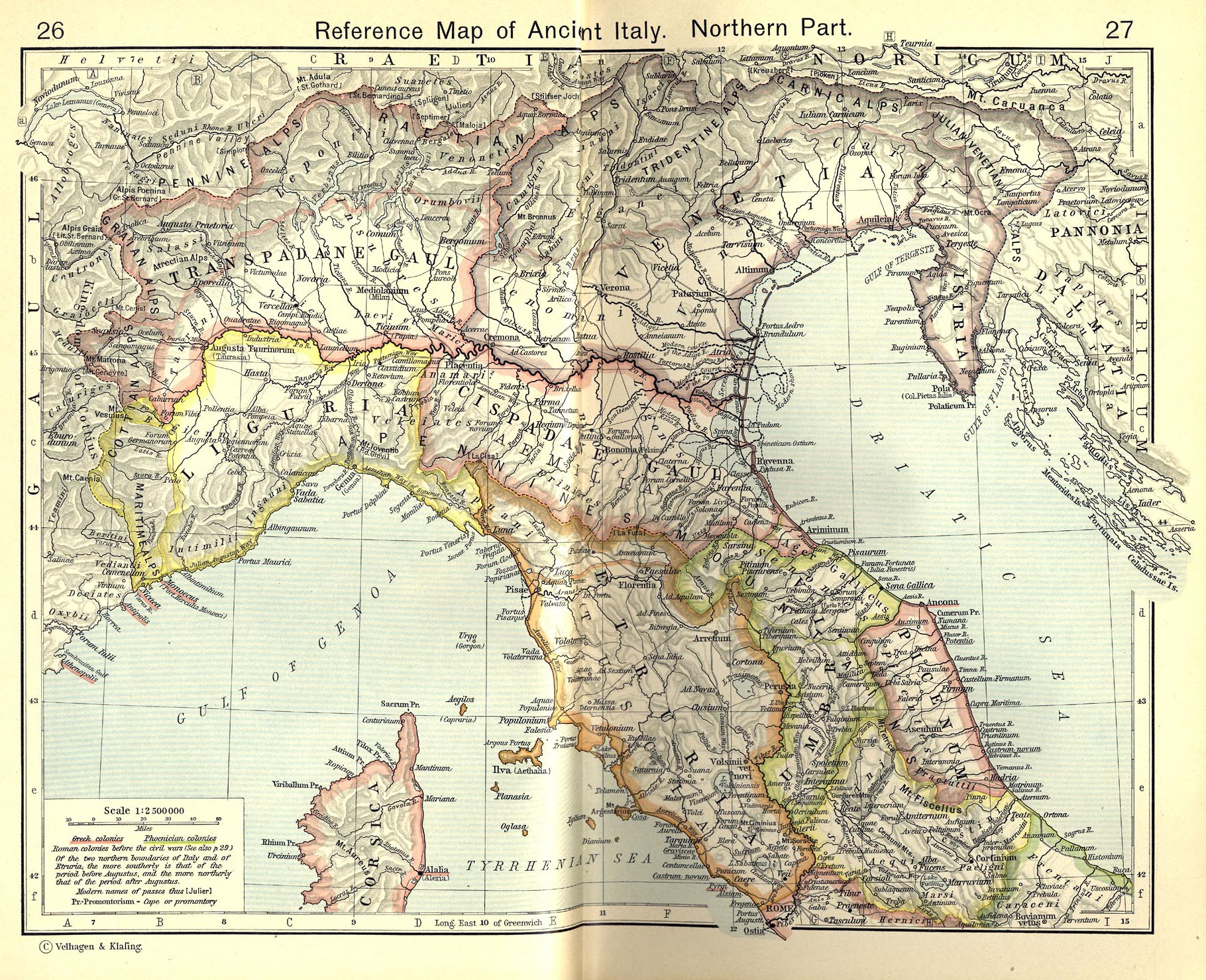
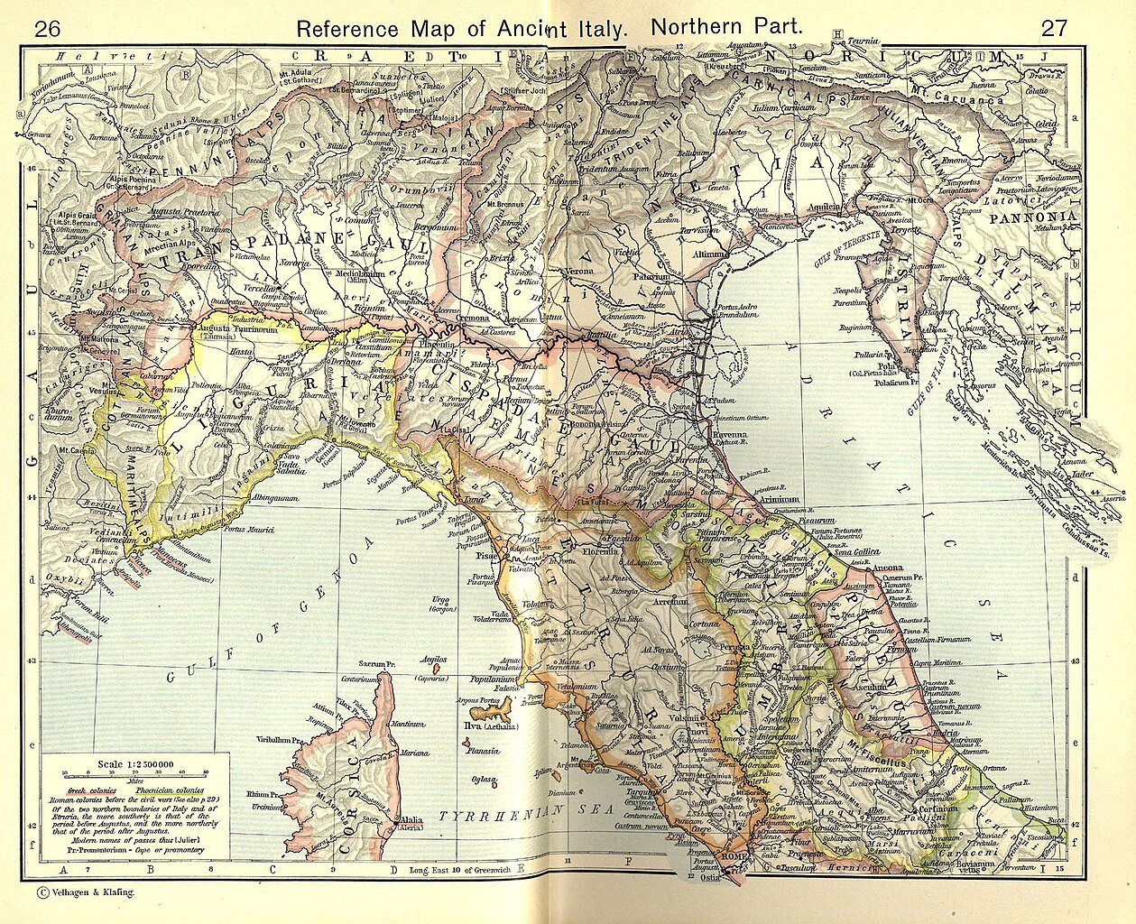
English: Reference Map of Ancient Italy, Northern Part [1]
Historical Atlas by William R. Shepherd, 1911. Courtesy of the University of Texas Libraries, The University of Texas at Austin. From The Historical Atlas by William R. Shepherd, 1911 edition |
| תאריך יצירה | 7 במרץ 2008 (תאריך העלאה) |
| מקור | Historical Atlas by William R. Shepherd 1911 edition |
| יוצר | Historical Atlas by William R. Shepherd 1911 edition |
| אישורים והיתרים (שימוש חוזר בקובץ זה) |
This image is in the public domain due to its age. See also http://www.lib.utexas.edu/usage_statement.html?maps=yes |
| גרסאות אחרות | Derivative works of this file: Ancient Umbria.png |
![[1]](http://www.lib.utexas.edu/maps/historical/shepherd_1911/shepherd-c-026-027.jpg)
רישיון
|
יצירה זו נמצאת בנחלת הכלל במדינת המקור ובמדינות אחרות בהם תקופת זכויות היוצרים היא משך חיי היוצר ו-70 שנה (או פחות) מפטירתו.
| |
| הקובץ הזה זוהה כקובץ חופשי מכל מגבלה ידועה תחת חוק זכויות היוצרים, כולל כל הזכויות הקשורות והסמוכות. | |
קובץ מדיה זה נמצא ברשות הציבור בארצות הברית. זה תקף לעבודות אמריקניות שבהן זכויות היוצרים פגו, לעתים מסיבה שהפרסום הראשון היה לפני 1 בינואר 1929. ראו דף זה להסבר נוסף.
|
 | |
 |
תמונה זו עשויה שלא להיות תחת רשות הציבור מחוץ לארצות הברית (זה נכון במיוחד במדינות ובאזורים שבהם לא חל rule of the shorter term עבור יצירות אמריקניות, ובהן קנדה, סין היבשתית (לא כולל הונג קונג ומקאו), גרמניה, מקסיקו, ושוויץ). היוצר ושנת הפרסום הם מידע חיוני שחובה לציין. ראו הסבר על רשות הציבור וזכויות יוצרים למידע נוסף.
|
היסטוריית הקובץ
ניתן ללחוץ על תאריך/שעה כדי לראות את הקובץ כפי שנראה באותו זמן.
| תאריך/שעה | תמונה ממוזערת | ממדים | משתמש | הערה | |
|---|---|---|---|---|---|
| נוכחית | 21:52, 19 ביולי 2010 | | 1,480 × 1,820 (1.21 מ"ב) | Cropbot | upload cropped version, operated by User:Beao. Summary: cropped |
| 11:02, 1 ביולי 2007 |  | 1,545 × 1,902 (831 ק"ב) | Accurimbono | == Summary == Map of Northen Italy during the Roman period. Extracted from ''The Historical Atlas'' by William R. Shepherd, 1911. Original image is at http://www.lib.utexas.edu/maps/historical/shepherd_1911/shepherd-c-026-027.jpg [ |
שימוש בקובץ
![]() אין בוויקיפדיה דפים המשתמשים בקובץ זה.
אין בוויקיפדיה דפים המשתמשים בקובץ זה.
שימוש גלובלי בקובץ
אתרי הוויקי השונים הבאים משתמשים בקובץ זה:
- שימוש באתר ast.wikipedia.org
- שימוש באתר bg.wikipedia.org
- שימוש באתר br.wikipedia.org
- שימוש באתר ca.wikipedia.org
- שימוש באתר cs.wikipedia.org
- שימוש באתר de.wikipedia.org
- שימוש באתר en.wikipedia.org
- שימוש באתר es.wikipedia.org
- שימוש באתר et.wikipedia.org
- שימוש באתר fr.wikipedia.org
- שימוש באתר it.wikipedia.org