
משתמש:בנצי/ארגז חול ??: נחל (או ערוץ ?) האבאסו
תבנית:Inappropriate person תבנית:Geobox
נחל (או ערוץ ?) האבאסו הוא ??? (stream) במדינת אריזונה בארה"ב, הקשור (???, associated - נכון דקדוקית, לבדוק דיוק הקשרי) באנשי (???) האבאסופאי ([[]]). נחל זה הוא יובלו של נהר קולורדו, הנשפך אליו בקניון הגדול (כללי מדי).
Havasu Creek is a stream in the U.S. state of Arizona associated with the Havasupai people. It is a tributary to the Colorado River, which it enters in the Grand Canyon.
אודות (לשנות)[עריכת קוד מקור | עריכה]
מוצא ההאבאסו הוא מעל קיר הקניון, כזרזיף קטן שמקורו בנגר של הפשרת שלגים ומי גשמים (הניסוח האנגלי לא מדוייק מבחינת 'נגר'). זרימה זו מתפתלת על המישורים מעל הקניון לאורך כ-80 ק"מ (50 מילים) עד שהם נכנסים לקניון מפלי האבאסו. הם מגיעים אז למעיינות האבאסו, שם נהר תת-קרקעי מזין את הנחל. ניתן לגשת למעיינות דרך מעלה הזרם (לרשום את הביטוי המקורי באנגלית) כשפוגשים בנחל בפעם הראשונה. מי המעיין שומרים על טמפרטורה של 210C לאורך כל השנה. הנחל קנה את פרסומו בשל הצבע הכחול-ירוק (להוסיף שם היבטים פיזיקליים) של מימיו, ותצורות (אין ע"ע) הטרוורטין (אין ע"ע) המיוחדות שלו. תכונות אלה נובעות מכמויות גדולות של סידן פחמתי (אבן גיר) (להזכיר 'קלציט' ? + להשלים בירור מה שביניהם, אם בכלל) המומס במים אשר יצרו את דפנותיו (???) של ערוץ הנחל, וגורמים לתכונות ההחזרה החזקות של צבעים אלה. עובדה זו גם מקנה לנחל תכונה מעניינת של הישתנות מתמדת (??? - להחליט על התירגום הסופי + התייחסות זו רלוונטית גם לערך המפלים), הנובעת מכך שסביב כל עצם הנופל אל המים מתגבשת במהירות שכבה מינרלית, מה שגורם ליצירתן של תצורות חדשות, אשר משנות בעצמן, את זרימת הנחל ואת כיוונו (הנה ההסבר). בשל כך, הנחל לעולם לא נראה אותו דבר משנה לשנה (?). הנחל זורם דרך הכפר סופאי, ובסופו של דבר נשפך אל נהר קולורדו.
About[עריכת קוד מקור | עריכה]
Havasu Creek starts out above the canyon wall as a small trickle of snow run-off and rain water. This water meanders on the plains above the canyon for about 50 מיל (80 קילומטרים) until it enters Cataract (Havasu) Canyon. It then reaches Havasu Springs, where an underground river feeds the creek. This spring can be accessed by heading upstream when the creek is first encountered. The water stays at about 70 °F (21 °C) all year around. The creek is well known for its blue-green color and distinctive travertine formations. This is due to large amounts of calcium carbonate (lime) in the water that formed the limestone that lines the creek and reflects its color so strongly. This also gives the creek an interesting feature as it is ever changing. This occurs because any items that fall into the stream mineralize very quickly, causing new formations and changing the flow of the water. This causes the creek to never look the same from one year to another. The creek runs through the village of Supai, and it ultimately flows into the Colorado River.
מפלי נאבאחו[עריכת קוד מקור | עריכה]
[עריכת קוד מקור | עריכה]

Until the August 2008 flooding, Navajo Falls was the first prominent waterfall in the canyon. They were named after an old Supai chief. It was located 1.25 מיל (2 קילומטרים) from Supai and is accessed from a trail located on the left side (right side when heading upstream) of the main trail. This side trail leads down to the creek, where there is a crude bridge that crosses over the creek. The trail then leads back into the trees, where the main pool and falls were located. The pool was popular for its seclusion and its ease to swimmers. The falls were approximately 70 רגל (21 מטרים) tall and consisted of separate sets of water chutes, the main one located on the right side where the water cascaded down the canyon hill. To the left of the main chute there were other smaller ones that were steeper and more vertical. There were a few places that are viable for cliff jumping, although caution was necessary.
In August 2008, Navajo Falls was completely destroyed by a flood. According to The New York Times: תבנית:Quote
Havasu Falls[עריכת קוד מקור | עריכה]

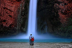
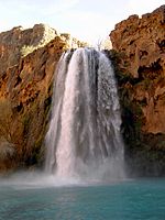
Havasu Falls (Havasupai: Havasuw Hagjahgeevma[1]) is the second waterfall in the canyon. It is located at 36°15′18″N 112°41′52″W / 36.25500°N 112.69778°W (1 ½ miles from Supai) and is accessed from a trail on the right side (left side when heading upstream) of the main trail. The side trail leads across a small plateau and drops into the main pool. Havasu is arguably the most famous and most visited of all the falls. The falls consist of one main chute that drops over a 120-רגל (37-מטר) vertical cliff (due to the high mineral content of the water, the falls are ever-changing and sometimes break into two separate chutes of water) into a large pool.
The falls are known for their natural pools, created by mineralization, although most of these pools were damaged and/or destroyed in the early 1990s by large floods that washed through the area. A small man-made dam was constructed to help restore the pools and to preserve what is left. There are many picnic tables on the opposite side of the creek and it is very easy to cross over by following the edges of the pools. It is possible to swim behind the falls and enter a small rock shelter behind it.
It is interesting to note that the falls were called "Bridal Veil Falls" before the flood of 1910 because they fell from the entire width of the now dry travertine cliffs north and south of the present falls.
Mooney Falls[עריכת קוד מקור | עריכה]

Mooney Falls is the third main waterfall in the canyon. It is named after D. W. "James" Mooney, a miner, who in 1882 (according to his companions) decided to mine the area near Havasu Falls for minerals. The group then decided to try Mooney Falls. One of his companions was injured, so James Mooney decided to try to climb up the falls with his companion tied to his back, and subsequently fell to his death. The Falls are located 2.25 מיל (3.6 קילומטרים) from Supai, just past the campgrounds. The trail leads to the top of the falls, where there is a lookout/photograph area that overlooks the 210-רגל (64-מטר) canyon wall that the waterfall cascades over. In order to gain access to the bottom of the falls and its pool, a very rugged and dangerous descent is required. Extreme care and discretion for the following portion is required; it is highly exposed and should not be attempted when the weather and/or conditions are not suitable.
The trail down is located on the left side (looking downstream), up against the canyon wall. The first half of the trail is only moderately difficult until the entrance of a small passageway/cave is reached. At this point the trail becomes very difficult and very precarious. The small passageway is large enough for the average human, and leads to a small opening in which another passageway is entered. At the end of the second passageway the trail becomes a semi-vertical rock climb. At this point it is advisable to turn your body around like you are descending a ladder. There are strategically placed chains, handholds, and ladders to aid in the climb. Take extreme caution and do not rush.
More than likely the rock will become slippery due to the mist from the falls, and there will probably be people heading up. Always let the person who is the most exposed to pass. The pool is the largest of the three, and along with the others there are some places for cliff-jumping (please use extreme caution). It is possible to swim to the left of the falls to the rock wall, and then shimmy your way across the rock (while staying in the water) to a small cave that is located just above the water line, approximately 15–20 feet (5 to 6 meters) away from the falls (only attempt if you are a strong swimmer). There is an island located in the middle, which breaks the pool into two streams.
Beaver Falls[עריכת קוד מקור | עריכה]

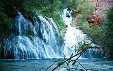
Beaver Falls is arguably the fourth set of falls, although many claim that it is not a waterfall, but merely a set of small falls that are located close to each other. The falls are located approximately 6 מיל (9.7 קילומטרים) downstream of Supai, and are the most difficult to access. To reach the falls, follow the trail down to Mooney Falls. After descending the last ladder, look to the left (downstream) and there is a visible trail.
About 1/4 of a mile down, there is a small stream which feeds into the creek, over the side of the cliff, effectively creating a place to shower. Follow the trail off to the right towards the creek, then back towards Mooney Falls a bit and you'll find this mini-waterfall. Please do not use any soap (biodegradable or otherwise) so as not to pollute the creek. About 1/2 of a mile down, there is a nice rope-swing (take extreme caution).
The next 3–4 miles are remote and rugged, and require multiple crossings of the creek. The trail is tough to follow at some points, but all that is required is to head downstream. The trail will lead to a point where there appears to be no way to go, except for getting wet. But to the right, on the rock ledge, there is a rope hanging down (always test ropes you did not place before climbing them). Climb up this rope. It is a difficult climb of around 8 רגל (2.4 מטרים), but the rope is located above the water, so any fall will be lessened.
Follow the trail up and follow it downstream. There is a rock chute/slide located to your left; this is the difficult access to the falls. There is an easier access point if you hike to the point just before the trail turns north to continue down the canyon. Look for ducks here. River rafters have beaten a path to the ledges where they jump. Go on upstream, gradually working your way to the creek bed. Climb down to the creek and the falls are just upstream. These pools are small, but still offer good swimming. Like the previous three falls, there are many places to cliff-jump and there are many good sites to explore.
Beaver Falls was once much more impressive. It had a height of about fifty feet in one fall, right at the junction of Beaver Canyon and Havasu Canyon. The great flood of January 1910 destroyed it, leaving the falls over the limestone ledges as they are today. Rotted cottonwood logs near the aforementioned junction show how high the water rose during that flood.
Confluence[עריכת קוד מקור | עריכה]
From Beaver Falls, the creek heads down to the Colorado River. There are multiple ways to reach the river, yet the best is to go back up the chute to the trail and follow that downstream. The 3-mile (5 km) hike is long, difficult, and rugged, and it is only advisable for experienced hikers. The creek ends at the confluence, where there are some camping areas. This spot is also popular for river rafters to stop and to head up the canyon.
Flooding[עריכת קוד מקור | עריכה]


On August 17, 2008, the Redlands Dam on Havasu Creek burst after days of heavy rain. The potential threat to human life by the floodwaters caused the local authorities to evacuate the village, and rescue crews airlifted about 400 people to safety.[2] In addition, Navajo Falls was destroyed in the flooding and new, yet-unnamed falls were formed.[3]
Gallery[עריכת קוד מקור | עריכה]
-
 Mooney Falls in the morning
 -
 Navajo Falls before the flood
 -
 Havasu Falls at night
 -
 Mooney Falls
 -
 Beaver Falls
 -
 Havasu Falls in December


References[עריכת קוד מקור | עריכה]
- ^ Hinton, Leanne (1984). A dictionary of the Havasupai language.
- ^ Reid, Betty; Boehnke, Megan; Leung, Lily (17 באוגוסט 2008). "Hundreds Evacuated Near Grand Canyon After Flooding". The Arizona Republic. נבדק ב-29 בנובמבר 2012.
{{cite news}}: (עזרה) - ^ Fonseca, Felicia (ביוני 2009). "Havasupai Reopen Flooded Site to Visitors". News from Indian Country. Associated Press. נבדק ב-26 בינואר 2012.
{{cite news}}: (עזרה)