
קובץ:Lexington Concord Siege of Boston.jpg
גודל התצוגה המקדימה הזאת: 778 × 600 פיקסלים. רזולוציות אחרות: 311 × 240 פיקסלים | 623 × 480 פיקסלים | 996 × 768 פיקסלים | 1,280 × 987 פיקסלים | 2,560 × 1,974 פיקסלים | 3,211 × 2,476 פיקסלים.
לקובץ המקורי (3,211 × 2,476 פיקסלים, גודל הקובץ: 1.55 מ"ב, סוג MIME: image/jpeg)
| זהו קובץ שמקורו במיזם ויקישיתוף. תיאורו בדף תיאור הקובץ המקורי (בעברית) מוצג למטה. |
תקציר
| תיאור |
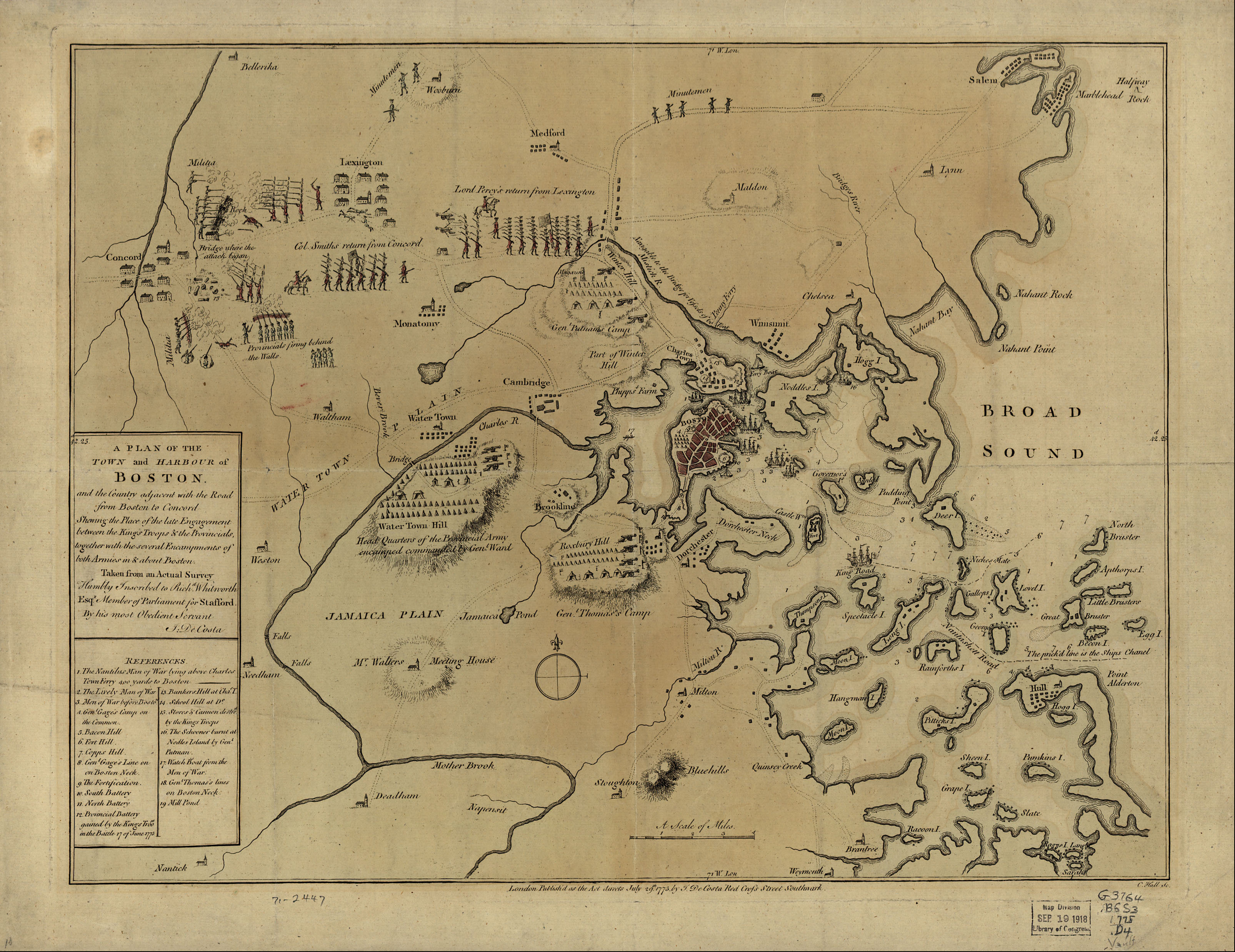
English: A mostly accurate hand-colored map depicting the 1775 Battles of Lexington and Concord and the Siege of Boston |
| תאריך יצירה | |
| מקור |
From the Library of Congress American Memory. |
| יוצר | J. DeCosta |
| גרסאות אחרות |
 |
Large text box
a PLAN of the
TOWN and HARBOUR of
Boston.
and the Country adjacent with the Road
from Boston to Concord
Shewing the Place of the late Engagement
between the King's Troops & the Provincials,
together with the several Encampments of
both Armies in & about Boston.
Taken from an Actual Survey
Humbly Inscribed to Rich d. Whitworth
Esqr. Member of Parliament for Stafford
Legend
References.
- The Nautilus Man of War lying above Charles
- Town Ferry 400 yards to Boston
- The Lively Man of War
- Men of War before Boston.
- Gen l. Gage's Camp on
- the Common.
- Bacon Hill [i.e. Beacon Hill]
- Fort Hill.
- Copps Hill.
- Gen l. Gage's Line on
- on Boston Neck.
- The Fortification.
- South Battery
- North Battery
- Provincial Battery
- gained by the King's Troo ps
- in the Battle 17 of June 1775
- Bunkers Hill at Cha s. T.
- School Hill at D o.
- Stores & Cannon destro d
- by the King's Troops
- The Schooner burnt at
- Nodles Island by Gen l.
- Putman
- Watch Boat from the Men of War.
- Gen l. Thomas's lines
- on Boston Neck
- Mill Pond
Text along the bottom
- London Publish'd as the Act directs July 29th. 1775 by J. De Costa Red Croſs Street Southwark.

|
map זה זמין במחלקת {{{division_name}}} תחת מספר מזהה: g3764b.ar090000. תבנית זו אינה מעידה על מצב זכויות היוצרים של היצירה. לתבנית זו יש לצרף תבנית רישיון מתאימה.
|
|
יצירה זו נמצאת בנחלת הכלל במדינת המקור ובמדינות אחרות בהם תקופת זכויות היוצרים היא משך חיי היוצר ו-100 שנה (או פחות) מפטירתו.
| |
| הקובץ הזה זוהה כקובץ חופשי מכל מגבלה ידועה תחת חוק זכויות היוצרים, כולל כל הזכויות הקשורות והסמוכות. | |
היסטוריית הקובץ
ניתן ללחוץ על תאריך/שעה כדי לראות את הקובץ כפי שנראה באותו זמן.
| תאריך/שעה | תמונה ממוזערת | ממדים | משתמש | הערה | |
|---|---|---|---|---|---|
| נוכחית | 10:30, 10 במאי 2005 | | 2,476 × 3,211 (1.55 מ"ב) | Flying Jazz | "A plan of the town and harbour of Boston and the country adjacent with the road from Boston to Concord, shewing the place of the late engagement between the King's troops & the provincials, together with the several encampments of both armies in & about |
שימוש בקובץ
![]() אין בוויקיפדיה דפים המשתמשים בקובץ זה.
אין בוויקיפדיה דפים המשתמשים בקובץ זה.
שימוש גלובלי בקובץ
אתרי הוויקי השונים הבאים משתמשים בקובץ זה:
- שימוש באתר azb.wikipedia.org
- שימוש באתר az.wikipedia.org
- שימוש באתר ca.wikipedia.org
- שימוש באתר cs.wikipedia.org
- שימוש באתר da.wikipedia.org
- שימוש באתר de.wikipedia.org
- שימוש באתר en.wikipedia.org
- שימוש באתר en.wikivoyage.org
- שימוש באתר es.wikipedia.org
- שימוש באתר fi.wikipedia.org
- שימוש באתר fo.wikipedia.org
- שימוש באתר fr.wikipedia.org
- שימוש באתר fr.wikiversity.org
- שימוש באתר it.wikipedia.org
- שימוש באתר it.wikivoyage.org
- שימוש באתר ja.wikipedia.org
- שימוש באתר no.wikipedia.org
- שימוש באתר pl.wikipedia.org
- שימוש באתר ro.wikipedia.org
- שימוש באתר sr.wikipedia.org
- שימוש באתר th.wikipedia.org
- שימוש באתר www.wikidata.org
- שימוש באתר zh.wikipedia.org