
קובץ:1581 Bunting clover leaf map.jpg

גודל התצוגה המקדימה הזאת: 762 × 600 פיקסלים. רזולוציות אחרות: 305 × 240 פיקסלים | 610 × 480 פיקסלים | 976 × 768 פיקסלים | 1,280 × 1,008 פיקסלים | 2,560 × 2,015 פיקסלים | 4,441 × 3,496 פיקסלים.
לקובץ המקורי (4,441 × 3,496 פיקסלים, גודל הקובץ: 14.36 מ"ב, סוג MIME: image/jpeg)
| זהו קובץ שמקורו במיזם ויקישיתוף. תיאורו בדף תיאור הקובץ המקורי (בעברית) מוצג למטה. |
תקציר
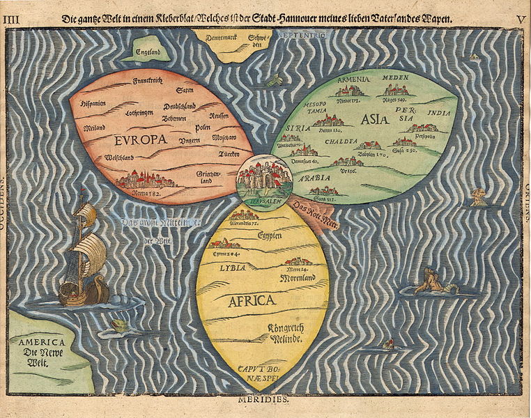
| היינריך בינטינג: Deutsch: „Die gantze Welt in einem Kleberblat / Welches ist der Stadt Hannover meines lieben Vaterlandes Wapen“
English: "The entire world in the shape of a clover-leaf, which is the emblem of the city of Hannover, my beloved homeland" ( |
||||||||||||||||||||||||||
|---|---|---|---|---|---|---|---|---|---|---|---|---|---|---|---|---|---|---|---|---|---|---|---|---|---|---|
| אומן |
|
|||||||||||||||||||||||||
| כותרת |
Deutsch: „Die gantze Welt in einem Kleberblat / Welches ist der Stadt Hannover meines lieben Vaterlandes Wapen“
English: "The entire world in the shape of a clover-leaf, which is the emblem of the city of Hannover, my beloved homeland" |
|||||||||||||||||||||||||
| תיאור |
Deutsch: Weltkarte aus dem Jahr 1581 in Form eines Kleeblattes: die drei klassischen Kontinenten Europa, Asien und Afrika bilden die Blätter und die Stadt Jerusalem das Zentrum. Zusätzlich sind England, Skandinavien und Amerika eingezeichnet. Erstellt von Heinrich Bünting und gedruckt in Magdeburg.
English: Stylized world map in the shape of a clover-leaf (the three classical continents of Europe, Asia, Africa), with Jerusalem at the center, with additional indication of Great Britain, Scandinavia and America / the New World. Page 4f. of Die eigentliche und warhafftige gestalt der Erden und des Meers (1581), printed in Magdeburg.
Українська: Стилізована карта світу у формі листка конюшини (три класичних континенти: Європа, Азія, Африка), з Єрусалимом у центрі, з додатковим позначенням Великобританії, Скандинавії та Америки / Нового Світу. 1581 р. надруковано в Магдебурзі. Автор: Генріх Бюнтінг. |
|||||||||||||||||||||||||
| תאריך יצירה | 1581 | |||||||||||||||||||||||||
| טכניקה | חיתוך-עץ (יצירה אמנותית) | |||||||||||||||||||||||||
| מקור/צלם | [1] | |||||||||||||||||||||||||
הערכה
|
תמונה זו נבחרה כתמונת היום בתאריך 28 במאי 2023. כותרתה: English: Stylized world map in the shape of a clover-leaf (the three classical continents of Europe, Asia, Africa), with Jerusalem at the center, with additional indication of Great Britain, Scandinavia and America / the New World. 1581 printed in Magdeburg. Drawn by Heinrich Bünting. שפות אחרות:
Čeština: Stylizovaná mapa světa ve tvaru listu jetele (tři klasické kontinenty - Evropa, Asie a Afrika) s Jeruzalémem uprostřed a s dodatečným označením Velké Británie, Skandinávie a Ameriky / Nového světa, vytištěno roku 1581 v Magdeburku, kreby Heinrich Bünting. Deutsch: Weltkarte aus dem Jahr 1581 in Form eines Kleeblattes: Die drei klassischen Kontinente Europa, Asien und Afrika bilden die Blätter und die Stadt Jerusalem das Zentrum. Zusätzlich sind England, Skandinavien und Amerika eingezeichnet. Erstellt von Heinrich Bünting und gedruckt in Magdeburg. English: Stylized world map in the shape of a clover-leaf (the three classical continents of Europe, Asia, Africa), with Jerusalem at the center, with additional indication of Great Britain, Scandinavia and America / the New World. 1581 printed in Magdeburg. Drawn by Heinrich Bünting. Español: Mapamundi estilizado en forma de hoja de trébol (los tres continentes clásicos de Europa, Asia y África), con Jerusalén en el centro y con indicación adicional de Gran Bretaña, Escandinavia y América/Nuevo Mundo. Dibujado por Heinrich Bünting, impreso en 1581 en Magdeburgo. Français : Carte du monde sous la forme d'un trèfle à trois feuilles représentant l'Europe, l'Asie et l'Afrique, avec Jérusalem en son centre. La Grande-Bretagne, la Scandinavie et les Amériques sont aussi mentionnées. Carte dessinée par Heinrich Bünting et imprimée à Magdeburg en 1581. Italiano: Planisfero a forma di trifoglio (in ogni fogliolina sono raffigurati i continenti del Vecchio Mondo: Europa, Asia e Africa), con Gerusalemme al centro, e indicate ai margini la Gran Bretagna, la Scandinavia e l'America (il Nuovo Mondo). Disegnato da Heinrich Bünting e stampato a Magdeburgo nel 1581. Magyar: Lóhere alakú stilizált világtérkép (a három klasszikus kontinens: Európa, Ázsia és Afrika), középen Jeruzsálemmel, továbbá Nagy-Britannia, Skandinávia és Amerika/Újvilág jelölésével. Heinrich Bünting rajzolta, 1581-ben nyomtatták Magdeburgban Nederlands: Wereldkaart uit 1581 met Jeruzalem in het midden, daaromheen de bekende werelddelen (Europa, Afrika en Azië) en aan de randen Scandinavië, Engeland en de Nieuwe Wereld Português: Mapa-múndi estilizado em forma de folha de trevo (os três continentes clássicos: Europa, Ásia e África), com Jerusalém no centro e indicação adicional da Grã-Bretanha, Escandinávia e América/Novo Mundo. Desenhado por Heinrich Bünting e impresso em Magdeburgo em 1581. Slovenščina: Stiliziran zemljevid v obliki deteljnega lista (tri klasične celine: Evropa, Azija, Afrika) z Jeruzalemom v središču, z dodatnimi oznakami Velike Britanije, Skandinavije in Amerike/Novega sveta. Narisal ga je Heinrich Bünting. Natisnjeno v Magdeburgu, 1581. Македонски: Германска стилизирана карта на светот од 1581 г. во облик на детелина (трите стари континенти) и Ерусалим во средиштето. Українська: Стилізована карта світу у формі листка конюшини (три класичних континенти: Європа, Азія, Африка), з Єрусалимом у центрі, з додатковим позначенням Великобританії, Скандинавії та Америки / Нового Світу. 1581 р. надруковано в Магдебурзі. Автор: Генріх Бюнтінг. |
רישיון
|
עבודת אמנות דו-מימדית זו המוצגת בתמונה שוחררה לרשות הציבור בכל העולם בעקבות תאריך מותו של היוצר, או תאריך פרסום היצירה. לפיכך, תצלום היצירה גם הוא ברשות הציבור.
הודעה זו תקפה לגבי התצלומים שנוצרו בארצות הברית, בגרמניה ובמדינות רבות נוספות.
| ||||
Derivative works
Derivative works of this file: 1581 Bunting clover leaf map-ar.png Derivative works of this file: خارطة العالم تتوسطها مدينة القدس.jpg
היסטוריית הקובץ
ניתן ללחוץ על תאריך/שעה כדי לראות את הקובץ כפי שנראה באותו זמן.
| תאריך/שעה | תמונה ממוזערת | ממדים | משתמש | הערה | |
|---|---|---|---|---|---|
| נוכחית | 08:48, 30 בנובמבר 2006 | | 3,496 × 4,441 (14.36 מ"ב) | Tarawneh | higher res. |
| 11:52, 12 באפריל 2006 |  | 1,472 × 1,736 (950 ק"ב) | Humus sapiens~commonswiki | == Summary == Bünting clover leaf map. A woodcut made in 1581 in Magdeburg. Jerusalem is in the center, surrounded by Europe, Asia and Africa. Source: [http://www.helmink.com/Antique_Map_Bunting_World/] Category:Jerusalem [[Category:Historical map |
שימוש בקובץ
הדפים הבאים משתמשים בקובץ הזה:
- היינריך בינטינג
- ירושלים
- מפת אורביס טרארום
- קרטוגרפיה של ארץ ישראל
- ויקיפדיה:תמונה מומלצת/הוספה למומלצים/ארכיון 5
- ויקיפדיה:תמונה מומלצת/הוספה למומלצים/דיונים/מיזם היובל
- ויקיפדיה:תמונה מומלצת/הוספה למומלצים/דיונים/מיזם היובל/ארכיון
- ויקיפדיה:תמונה מומלצת/המלצות קודמות/אוגוסט 2009
- ויקיפדיה:תמונה מומלצת/המלצות קודמות/אוגוסט 2011
- ויקיפדיה:תמונה מומלצת/המלצות קודמות/ינואר 2010
- תבנית:תמונה מומלצת 16 בינואר 2010
- תבנית:תמונה מומלצת 20 באוגוסט 2009
- תבנית:תמונה מומלצת 7 באוגוסט 2011
- פורטל:הספרייה הלאומית/מפות עתיקות/2
- פורטל:הספרייה הלאומית/מפות עתיקות/גלריה
- פורטל:ירושלים/ירושלים באמנות/23
- פורטל:ירושלים/ירושלים באמנות/גלריה
שימוש גלובלי בקובץ
אתרי הוויקי השונים הבאים משתמשים בקובץ זה:
- שימוש באתר af.wikipedia.org
- שימוש באתר alt.wikipedia.org
- שימוש באתר ar.wikipedia.org
- שימוש באתר av.wikipedia.org
- שימוש באתר bn.wikipedia.org
- שימוש באתר ca.wikipedia.org
- שימוש באתר cv.wikipedia.org
- שימוש באתר de.wikipedia.org
- שימוש באתר el.wikipedia.org
- שימוש באתר en.wikipedia.org
- T and O map
- Wikipedia:Picture of the day/Archive
- User talk:Midgley
- User talk:Kungfuadam/Archive 3
- Early world maps
- User talk:Guettarda/Archive13
- User talk:Conscious/Archive2
- User talk:Splash/Archive14
- User talk:Sceptre/Archive 8
- User talk:Rory096/Archive7
- User talk:Swatjester/archive4
- User talk:Tangotango/April 2006
- User talk:Crzrussian/Archive 4
- User talk:CambridgeBayWeather/Archive07
- User:RenamedUser jaskldjslak901/Archive11
- User talk:Tone/Archive2
- User talk:Deville/Archive 1
- User talk:Titoxd/Archive14
- User talk:Darwinek/Archive1
- User talk:UkPaolo/Archive 3
- User talk:Fish and karate/Archive 7
- User talk:Jusjih/Archives in Apr 2006
- User talk:DragonflySixtyseven/Archive03
- User:Leonardovillas
- User talk:Jfdwolff/Archive 20
- User:Halibutt/Archive13
- User talk:Ombudsman/Archive02
- User talk:Tom/Archive5
- User talk:SorryGuy/Archive 1
- User talk:The wub/archive07
- User:J. Naven/Me
- Wikipedia:Featured pictures/Diagrams, drawings, and maps/Maps
- User talk:CBHA
- Wikipedia talk:WikiProject Jewish history/Archive 1
- User:Florencelau
- User:Holyroller07
- User talk:Shlomke/Archive 1