
קובץ:Nauru map.jpg

גודל התצוגה המקדימה הזאת: 484 × 600 פיקסלים. רזולוציות אחרות: 194 × 240 פיקסלים | 387 × 480 פיקסלים | 994 × 1,232 פיקסלים.
לקובץ המקורי (994 × 1,232 פיקסלים, גודל הקובץ: 128 ק"ב, סוג MIME: image/jpeg)
| זהו קובץ שמקורו במיזם ויקישיתוף. תיאורו בדף תיאור הקובץ המקורי (בעברית) מוצג למטה. |

|
יש ליצור מחדש את התמונה locator map הזו באמצעות גרפיקה וקטורית כדוגמת קובץ SVG. לפעולה זו מספר יתרונות, כפי שניתן לקרוא (באנגלית) בדף Commons:Media for cleanup. אם ברשותכם קובץ SVG, אנא העלו אותו. לאחר מכן, החליפו תבנית זו בתבנית
{{vector version available|שם הקובץ.svg}} |


תקציר
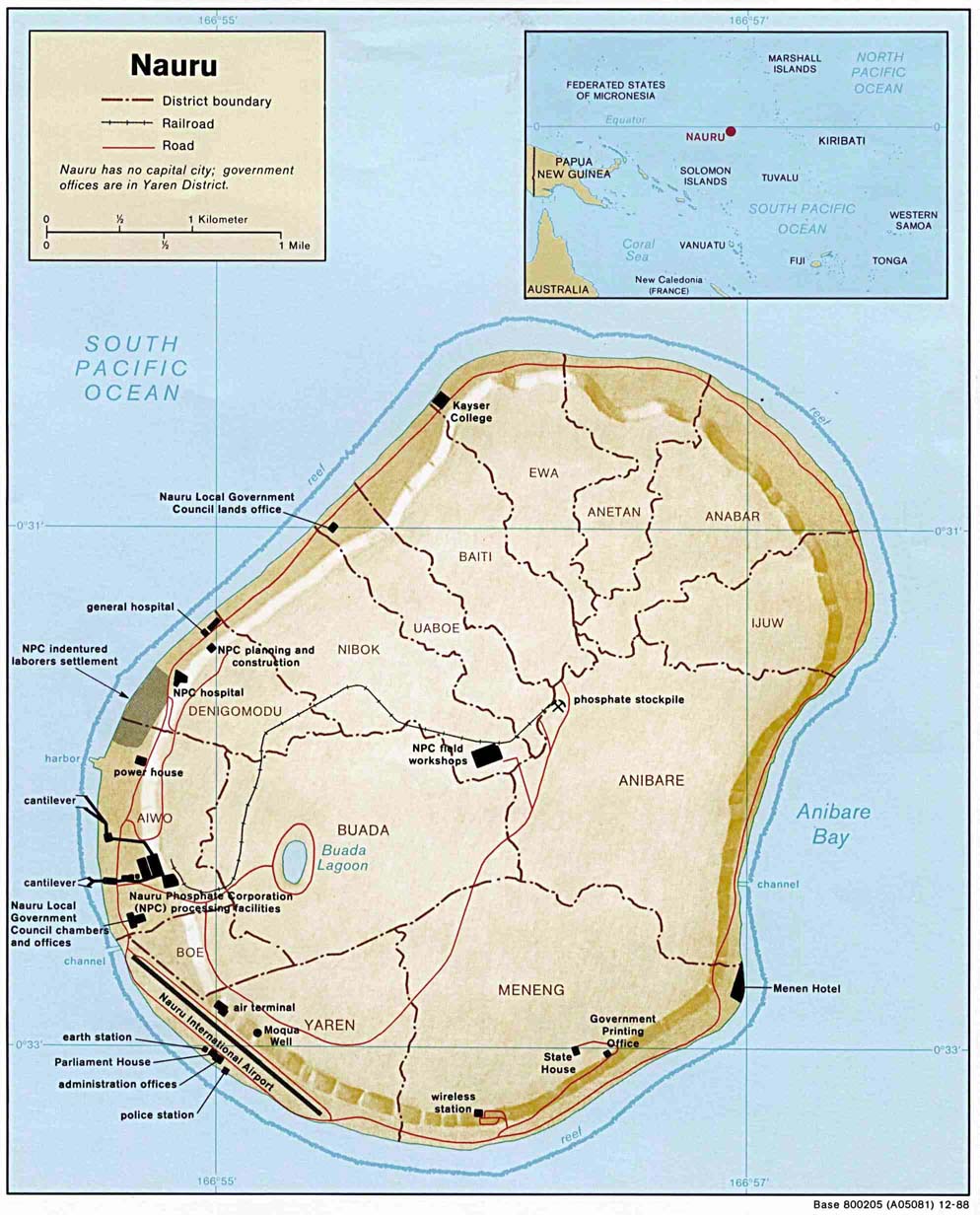
| תיאור | Small-label map of the island of Nauru (click image to enlarge for reading labels), northeast of Australia, north of the Solomon Islands and northwest of Fiji. The island is surrounded by a coral reef ring. The map shows some detailed contour areas near the shoreline. |
| תאריך יצירה | |
| מקור | Nauru (Shaded Relief) 1988 from Library Map Collection: Maps of Australia and the Pacific |
| יוצר | U.S. Central Intelligence Agency |
| אישורים והיתרים (שימוש חוזר בקובץ זה) |
Public domain |
| גרסאות אחרות |
Same map with larger labels: Image:Nauru_map_bold.jpg (has larger labels of nearby areas, the oceans, and district names). |
רישיון
| This image is a work of a Central Intelligence Agency employee, taken or made as part of that person's official duties. As a Work of the United States Government, this image or media is in the public domain in the United States.
|

|
היסטוריית הקובץ
ניתן ללחוץ על תאריך/שעה כדי לראות את הקובץ כפי שנראה באותו זמן.
| תאריך/שעה | תמונה ממוזערת | ממדים | משתמש | הערה | |
|---|---|---|---|---|---|
| נוכחית | 02:48, 27 במרץ 2005 | | 1,232 × 994 (128 ק"ב) | Jon Harald Søby | From the English Wikipedia. {{PD-USGov}} |
שימוש בקובץ
הדפים הבאים משתמשים בקובץ הזה:
- נאורו
- ויקיפדיה:הידעת?/2014/יולי
- ויקיפדיה:הידעת?/2016/אפריל
- ויקיפדיה:הידעת?/2018/אפריל
- ויקיפדיה:הידעת?/2020/אפריל
- ויקיפדיה:הידעת?/2023/אפריל
- תבנית:הידעת? 10 באפריל 2018
- תבנית:הידעת? 11 באפריל - סדרה 2
- תבנית:הידעת? 11 באפריל 2020
- תבנית:הידעת? 11 באפריל 2023
- תבנית:הידעת? 11 ביולי 2014
- תבנית:הידעת? 14 באפריל 2016
- פורטל:מדע המדינה/הידעת?/16
- פורטל:מדע המדינה/הידעת?/קטעי הידעת?
- פורטל:מדעי החברה/הידעת?/79
- פורטל:מדעי החברה/הידעת?/קטעי הידעת?
שימוש גלובלי בקובץ
אתרי הוויקי השונים הבאים משתמשים בקובץ זה:
- שימוש באתר azb.wikipedia.org
- שימוש באתר bg.wikipedia.org
- שימוש באתר en.wikipedia.org
- שימוש באתר id.wikipedia.org
- שימוש באתר incubator.wikimedia.org
- שימוש באתר ja.wikipedia.org
- שימוש באתר jv.wikipedia.org
- שימוש באתר ka.wikipedia.org
- שימוש באתר ms.wikipedia.org
- שימוש באתר sv.wikipedia.org
- שימוש באתר uk.wikipedia.org