
קובץ:1852 Middlesex Canal (Massachusetts) map.jpg

גודל התצוגה המקדימה הזאת: 411 × 599 פיקסלים. רזולוציות אחרות: 165 × 240 פיקסלים | 329 × 480 פיקסלים | 527 × 768 פיקסלים | 703 × 1,024 פיקסלים | 2,310 × 3,365 פיקסלים.
לקובץ המקורי (2,310 × 3,365 פיקסלים, גודל הקובץ: 9.03 מ"ב, סוג MIME: image/jpeg)
| זהו קובץ שמקורו במיזם ויקישיתוף. תיאורו בדף תיאור הקובץ המקורי (בעברית) מוצג למטה. |
_map.jpg)
_map.jpg?uselang=he)
תקציר
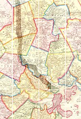
| תיאור | Map of the lower stretch of the Middlesex Canal, north of Boston, Massachusetts, 1852. This map was made about the time the canal was abandoned, some 50 years after its construction was completed. |
| תאריך יצירה | |
| מקור | Map entitled "Boston and vicinity", by F. G. Sidney and R. P. Smith, published by J. B. Shields of Boston, 1852. This scan is from the David Rumsey Map Collection, and has been cropped to remove extraneous terrain and digitally enhanced to emphasize the canal's route. |
| יוצר | F. G. Sidney and R. P. Smith. |
| אישורים והיתרים (שימוש חוזר בקובץ זה) |
The following text is taken from the David Rumsey web site: Images copyright © 2000 by Cartography Associates. Images may be reproduced or transmitted, but not for commercial use. For commercial use or commercial republication, contact carto@luna-img.com. This work is licensed under a Creative Commons License. |
רישיון
הקובץ הזה מתפרסם לפי תנאי רישיון קריאייטיב קומונז ייחוס 2.0 כללי.
- הנכם רשאים:
- לשתף – להעתיק, להפיץ ולהעביר את העבודה
- לערבב בין עבודות – להתאים את העבודה
- תחת התנאים הבאים:
- ייחוס – יש לתת ייחוס הולם, לתת קישור לרישיון, ולציין אם נעשו שינויים. אפשר לעשות את זה בכל צורה סבירה, אבל לא בשום צורה שמשתמע ממנה שמעניק הרישיון תומך בך או בשימוש שלך.
היסטוריית הקובץ
ניתן ללחוץ על תאריך/שעה כדי לראות את הקובץ כפי שנראה באותו זמן.
| תאריך/שעה | תמונה ממוזערת | ממדים | משתמש | הערה | |
|---|---|---|---|---|---|
| נוכחית | 19:49, 14 בינואר 2007 | | 3,365 × 2,310 (9.03 מ"ב) | Daderot | {{Information |Description=Map of the lower stretch of the Middlesex Canal, north of Boston, Massachusetts, 1852. This map was made about the time the canal was abandoned, some 50 years after its construction was completed. |Source=Map entitled "Boston an |
שימוש בקובץ
הדף הבא משתמש בקובץ הזה:
שימוש גלובלי בקובץ
אתרי הוויקי השונים הבאים משתמשים בקובץ זה:
- שימוש באתר arz.wikipedia.org
- שימוש באתר ceb.wikipedia.org
- שימוש באתר de.wikipedia.org
- שימוש באתר en.wikipedia.org
- Cambridge, Massachusetts
- Everett, Massachusetts
- Malden, Massachusetts
- Medford, Massachusetts
- Melrose, Massachusetts
- Woburn, Massachusetts
- Arlington, Massachusetts
- Reading, Massachusetts
- Stoneham, Massachusetts
- Wakefield, Massachusetts
- Winchester, Massachusetts
- Brighton, Boston
- Middlesex Canal
- History of Boston
- שימוש באתר fr.wikipedia.org
- שימוש באתר it.wikipedia.org
- שימוש באתר ja.wikipedia.org
- שימוש באתר pt.wikipedia.org
- שימוש באתר ro.wikipedia.org
- שימוש באתר ru.wikipedia.org
- שימוש באתר uk.wikipedia.org
- שימוש באתר www.wikidata.org
- שימוש באתר zh.wikipedia.org
_map.jpg)