
קובץ:AegithalosCaudatusIUCN.svg

גודל התצוגה המקדימה הזאת מסוג PNG של קובץ ה־SVG הזה: 800 × 566 פיקסלים. רזולוציות אחרות: 320 × 226 פיקסלים | 640 × 453 פיקסלים | 1,024 × 724 פיקסלים | 1,280 × 905 פיקסלים | 2,560 × 1,810 פיקסלים | 1,052 × 744 פיקסלים.
לקובץ המקורי (קובץ SVG, הגודל המקורי: 1,052 × 744 פיקסלים, גודל הקובץ: 12.71 מ"ב)
| זהו קובץ שמקורו במיזם ויקישיתוף. תיאורו בדף תיאור הקובץ המקורי (בעברית) מוצג למטה. |
תקציר
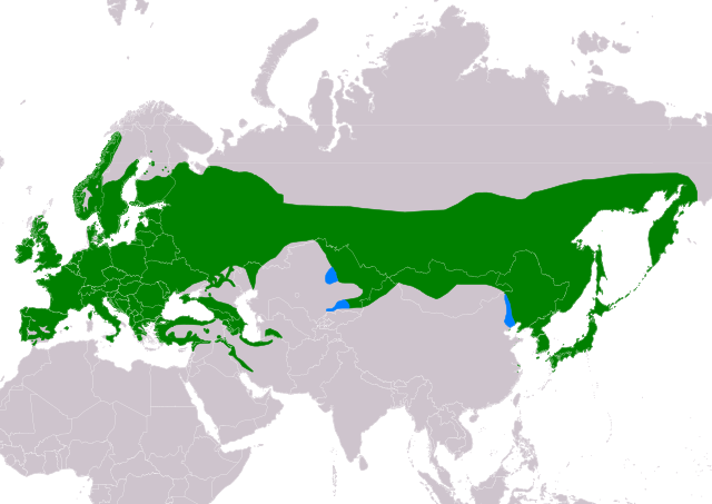
| תיאור |
Slovenčina: Mapa rozšírenia druhu mlynárka dlhochvostá (Aegithalos caudatus) podľa IUCN verzia 2021.2 (Zostavil: BirdLife International and Handbook of the Birds of the World (2016) 2016.):
legenda: Hniezdiaci, celoročný výskyt (#008000), Nehniezdiaci (#007FFF) English: Distribution map of Long-tailed Tit (Aegithalos caudatus) according to IUCN version 2021.2 (Compiled by: BirdLife International and Handbook of the Birds of the World (2016) 2016.); key: Legend: Extant, resident (#008000), Extant, non-breeding (#007FFF) |
| תאריך יצירה | |
| מקור | Made with Natural Earth. Free vector and raster map data @ naturalearthdata.com. Range map from BirdLife International. 2016. Aegithalos caudatus. The IUCN Red List of Threatened Species 2016: e.T103871923A87471081. https://dx.doi.org/10.2305/IUCN.UK.2016-3.RLTS.T103871923A87471081.en. Downloaded on 23 October 2021 as visual indicator of distribution. |
| יוצר | SanoAK: Alexander Kürthy |
רישיון

הקובץ הזה מתפרסם לפי תנאי רישיון קריאייטיב קומונז ייחוס-שיתוף זהה 3.0 לא מותאם.
ייחוס: IUCN Red List of Threatened Species, species assessors and the authors of the spatial data.
- הנכם רשאים:
- לשתף – להעתיק, להפיץ ולהעביר את העבודה
- לערבב בין עבודות – להתאים את העבודה
- תחת התנאים הבאים:
- ייחוס – יש לתת ייחוס הולם, לתת קישור לרישיון, ולציין אם נעשו שינויים. אפשר לעשות את זה בכל צורה סבירה, אבל לא בשום צורה שמשתמע ממנה שמעניק הרישיון תומך בך או בשימוש שלך.
- שיתוף זהה – אם תיצרו רמיקס, תשנו, או תבנו על החומר, חובה עליכם להפיץ את התרומות שלך לפי תנאי רישיון זהה או תואם למקור.
היסטוריית הקובץ
ניתן ללחוץ על תאריך/שעה כדי לראות את הקובץ כפי שנראה באותו זמן.
| תאריך/שעה | תמונה ממוזערת | ממדים | משתמש | הערה | |
|---|---|---|---|---|---|
| נוכחית | 17:09, 23 באוקטובר 2021 | | 744 × 1,052 (12.71 מ"ב) | SanoAK | Uploaded a work by SanoAK: Alexander Kürthy from Made with Natural Earth. Free vector and raster map data @ naturalearthdata.com. Range map from BirdLife International. 2016. Aegithalos caudatus. The IUCN Red List of Threatened Species 2016: e.T103871923A87471081. https://dx.doi.org/10.2305/IUCN.UK.2016-3.RLTS.T103871923A87471081.en. Downloaded on 23 October 2021 as visual indicator of distribution. with UploadWizard |
שימוש בקובץ
הדף הבא משתמש בקובץ הזה:
שימוש גלובלי בקובץ
אתרי הוויקי השונים הבאים משתמשים בקובץ זה:
- שימוש באתר de.wikipedia.org
- שימוש באתר en.wikipedia.org
- שימוש באתר eo.wikipedia.org
- שימוש באתר fi.wikipedia.org
- שימוש באתר fr.wikipedia.org
- שימוש באתר fy.wikipedia.org
- שימוש באתר hu.wikipedia.org
- שימוש באתר ko.wikipedia.org
- שימוש באתר nl.wikipedia.org
- שימוש באתר ru.wikipedia.org
- שימוש באתר sk.wikipedia.org
- שימוש באתר sr.wikipedia.org