
קובץ:American attack on Quebec.svg

לקובץ המקורי (קובץ SVG, הגודל המקורי: 883 × 1,077 פיקסלים, גודל הקובץ: 752 ק"ב)
| זהו קובץ שמקורו במיזם ויקישיתוף. תיאורו בדף תיאור הקובץ המקורי (בעברית) מוצג למטה. |
תקציר
| תיאור |
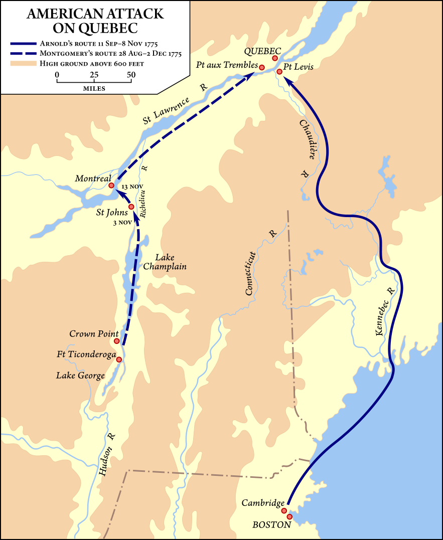
Map showing the routes taken by the Benedict Arnold and Richard Montgomery expeditions into Quebec as part of the American Invasion of Canada (1775). |
| תאריך יצירה | Vectorized September 19–20, 2008 |
| מקור | Vector version of Image:American quebec 1775.jpg, from American Military History, United States Army Center of Military History, 1989, courtesy of the University of Texas Libraries, The University of Texas at Austin. |
| יוצר | United States Army Center of Military History, vector version by Fvasconcellos (שיחה · תרומות) |
| אישורים והיתרים (שימוש חוזר בקובץ זה) |
This image is derived from a work of the U.S. government and, as such, is in the public domain. |
| גרסאות אחרות | Image:American quebec 1775.jpg |
רישיון
| This image is in the public domain because it contains materials that originally came from the United States Army Center of Military History, subject to the following qualification.
Note: The images of all badges, insignia, decorations and medals on the "CMH Online" web site are produced by the United States Army Institute of Heraldry and protected by Title 18, United States Code, Section 704 and the Code of Federal Regulations (32 CFR, Part 507). Permission to use these images for commercial purposes must be obtained from The Institute of Heraldry prior to their use. |

|
היסטוריית הקובץ
ניתן ללחוץ על תאריך/שעה כדי לראות את הקובץ כפי שנראה באותו זמן.
| תאריך/שעה | תמונה ממוזערת | ממדים | משתמש | הערה | |
|---|---|---|---|---|---|
| נוכחית | 04:54, 21 בספטמבר 2008 | | 1,077 × 883 (752 ק"ב) | Fvasconcellos | ==Summary== {{validSVG}} {{Information |Description=Map showing the routes taken by the {{w|Benedict Arnold}} and {{w|Richard Montgomery}} expeditions into Quebec as part of the American {{w|Invasion of Canada (1775)}}.<br/> Vector version of [[:Image:Ame |
שימוש בקובץ
הדף הבא משתמש בקובץ הזה:
שימוש גלובלי בקובץ
אתרי הוויקי השונים הבאים משתמשים בקובץ זה:
- שימוש באתר ca.wikipedia.org
- שימוש באתר da.wikipedia.org
- שימוש באתר de.wikipedia.org
- שימוש באתר en.wikipedia.org
- שימוש באתר es.wikipedia.org
- שימוש באתר fr.wikipedia.org
- שימוש באתר id.wikipedia.org
- שימוש באתר it.wikipedia.org
- שימוש באתר ja.wikipedia.org
- שימוש באתר ko.wikipedia.org
- שימוש באתר ms.wikipedia.org
- שימוש באתר pt.wikipedia.org
- שימוש באתר ro.wikipedia.org
- שימוש באתר ru.wikipedia.org
- שימוש באתר sh.wikipedia.org
- שימוש באתר uk.wikipedia.org
- שימוש באתר www.wikidata.org
- שימוש באתר zh.wikipedia.org