
קובץ:Ancient Egypt map-la.svg

גודל התצוגה המקדימה הזאת מסוג PNG של קובץ ה־SVG הזה: 293 × 598 פיקסלים. רזולוציות אחרות: 117 × 240 פיקסלים | 235 × 480 פיקסלים | 376 × 768 פיקסלים | 501 × 1,024 פיקסלים | 1,003 × 2,048 פיקסלים | 1,577 × 3,219 פיקסלים.
לקובץ המקורי (קובץ SVG, הגודל המקורי: 1,577 × 3,219 פיקסלים, גודל הקובץ: 1.57 מ"ב)
| זהו קובץ שמקורו במיזם ויקישיתוף. תיאורו בדף תיאור הקובץ המקורי (בעברית) מוצג למטה. |
תקציר
. Inkscape עם נוצרה ה תמונה
| תיאור |
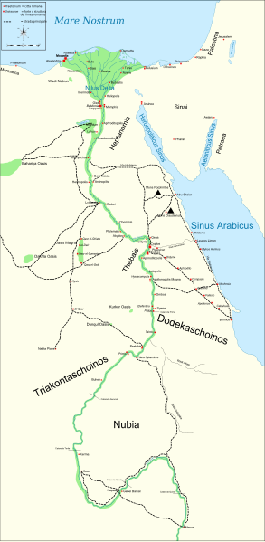
English: Map of Ancient Egypt, showing the Nile up to the fifth cataract, and major cities and sites of the Dynastic period (c. 3150 BC to 30 BC). Jerusalem is shown as reference cities. |
| תאריך יצירה | |
| מקור |
Own work. See #References for references used creating the map. |
| יוצר | Gigillo83 |
| גרסאות אחרות |
[]
|


|
SVG עושה שימוש בטקסט שניתן לתרגם בקלות לשפתך. לפרטים נוספים. עבור תמונות SVG, ניתן להשתמש ב[toolforge:svgtranslate/File:Ancient_Egypt_map-la.svglink כלי עזר] כדי לתרגם את התמונה לשפתך. |
רישיון
אני, בעל זכויות היוצרים על היצירה הזאת, מפרסם אותה בזאת תחת הרישיונות הבאים:

|
מוענקת בכך הרשות להעתיק, להפיץ או לשנות את המסמך הזה, לפי תנאי הרישיון לשימוש חופשי במסמכים של גנו, גרסה 1.2 או כל גרסה מאוחרת יותר שתפורסם על־ידי המוסד לתוכנה חופשית; ללא פרקים קבועים, ללא טקסט עטיפה קדמית וללא טקסט עטיפה אחורית. עותק של הרישיון כלול בפרק שכותרתו הרישיון לשימוש חופשי במסמכים של גנו. |
הקובץ הזה מתפרסם לפי תנאי רישיונות קריאייטיב קומונז ייחוס–שיתוף זהה 4.0 בין־לאומי, 3.0 לא מותאם, 2.5 כללי, 2.0 כללי ו־1.0 Generic.
- הנכם רשאים:
- לשתף – להעתיק, להפיץ ולהעביר את העבודה
- לערבב בין עבודות – להתאים את העבודה
- תחת התנאים הבאים:
- ייחוס – יש לתת ייחוס הולם, לתת קישור לרישיון, ולציין אם נעשו שינויים. אפשר לעשות את זה בכל צורה סבירה, אבל לא בשום צורה שמשתמע ממנה שמעניק הרישיון תומך בך או בשימוש שלך.
- שיתוף זהה – אם תיצרו רמיקס, תשנו, או תבנו על החומר, חובה עליכם להפיץ את התרומות שלך לפי תנאי רישיון זהה או תואם למקור.
הנכם מוזמנים לבחור את הרישיון הרצוי בעיניכם.
References
Resources used to create the map:
- Shaw, Ian , ed. (2003) The Oxford History of Ancient Egypt, Oxford University Press ISBN: 0-19-280293-3.
- Dr. Peter Der Manuelian , ed. (1998) Egypt: The World of the Pharaohs, Bonner Straße, Köln (Deutschland): Könemann Verlagsgesellschaft mbH ISBN: 3-89508-913-3.
- Digital Egypt - maps. Retrieved on 2007-11-25.
- NASA PIA04957. Retrieved on 2007-11-25.
- NASA PIA02647. Retrieved on 2007-11-25.
- NASA PIA04965. Retrieved on 2007-11-25.
Reference coordinates:
- Sais 30°57′53″N, 30°46′6″E
- Buto 31°11′47″N, 30°44′41″E
- Alexandria 31°11′53″N 29°55′09″E
- Naukratis 30°54' N 30°35'E coordinates here
- Tanis 30°58′37″N, 31°52′48″E
- Avaris 30°47′N, 31°50′E
- Busiris 30°54′40″N, 31°14′40″E
יומן העלאה מקורי
The original description page is/was here. All following user names refer to Commons.
- 2009-01-29 13:21 Bibi Saint-Pol 1577×3219×0 (412000 bytes) (remove wrong text, adjust frame)
- 2009-01-29 12:47 Bibi Saint-Pol 1577×3219×0 (413000 bytes) (added frame)
- 2009-01-29 12:35 Bibi Saint-Pol 1577×3219×0 (412000 bytes) (harmonize colors with the standards + replace unsupported Arial fonts by DejaVu )
- 2008-02-11 06:55 Jeff Dahl 1577×3219×0 (391000 bytes) (sp fx)
- 2007-11-29 02:09 Jeff Dahl 1577×3219×0 (391000 bytes) (Rotate Mediterranean Sea label)
- 2007-11-27 23:32 Jeff Dahl 1577×3219×0 (391000 bytes) (Minor adjustments to Naukratis and Buto)
- 2007-11-27 18:59 Jeff Dahl 1577×3219×0 (391000 bytes) (Cairo and Jerusalem now with black dots/italics)
- 2007-11-23 00:04 Jeff Dahl 1577×3219×0 (391000 bytes) (fx scalebar)
- 2007-11-22 23:56 Jeff Dahl 1577×3219×0 (391000 bytes) ({{Information |Description=A map of ancient Egypt, made with Inkscape |Source=self-made |Date=11-22-07 |Author= Jeff Dahl |Permission= |other_versions={{DerivativeVersions|Ancient Egypt map-ru.svg}} }} )
היסטוריית הקובץ
ניתן ללחוץ על תאריך/שעה כדי לראות את הקובץ כפי שנראה באותו זמן.
| תאריך/שעה | תמונה ממוזערת | ממדים | משתמש | הערה | |
|---|---|---|---|---|---|
| נוכחית | 00:54, 2 במרץ 2010 | | 3,219 × 1,577 (1.57 מ"ב) | Gigillo83 | Fix write |
| 18:26, 20 בינואר 2010 |  | 3,219 × 1,577 (446 ק"ב) | Gigillo83 | Aggiungo strada | |
| 17:59, 20 בינואר 2010 |  | 3,219 × 1,577 (444 ק"ב) | Gigillo83 | Aggiunti nomi e corretti luoghi | |
| 15:37, 17 בינואר 2010 |  | 3,219 × 1,577 (414 ק"ב) | Gigillo83 | Aggiunte vie e impianti militari | |
| 14:53, 6 בינואר 2010 |  | 3,219 × 1,577 (407 ק"ב) | Gigillo83 | == {{int:filedesc}} == {{inkscape}} {{Information |Description= {{en|Map of Ancient Egypt, showing the Nile up to the fifth cataract, and major cities and sites of the Dynastic period (c. 3150 BC to 30 BC). Jerusalem is shown as reference cities.}} |Sourc |
שימוש בקובץ
הדף הבא משתמש בקובץ הזה:
שימוש גלובלי בקובץ
אתרי הוויקי השונים הבאים משתמשים בקובץ זה:
- שימוש באתר bg.wikipedia.org
- שימוש באתר cv.wikipedia.org
- שימוש באתר el.wikipedia.org
- שימוש באתר en.wikipedia.org
- שימוש באתר es.wikipedia.org
- שימוש באתר fr.wikipedia.org
- שימוש באתר it.wikipedia.org
- Limes (storia romana)
- Egitto (provincia romana)
- Prefetto d'Egitto
- Dodecascheno
- Augusto
- Campagne augustee lungo il fronte africano ed arabico
- Limes africano
- Progetto:Laboratorio grafico/Immagini da migliorare/Archivio risolte/39
- Via Hadriana
- Classis Alexandrina
- Politica estera di Augusto
- Utente:Barjimoa/SandboxP
- שימוש באתר la.wikipedia.org
- שימוש באתר mk.wikipedia.org
- שימוש באתר nl.wikipedia.org
- שימוש באתר pl.wikipedia.org
- שימוש באתר ru.wikipedia.org
- שימוש באתר uk.wikipedia.org
- שימוש באתר www.wikidata.org