קובץ:Bering Sea ESA376705.jpg

תוכן הדף אינו נתמך בשפות אחרות.
מתוך ויקיפדיה, האנציקלופדיה החופשית

לקובץ המקורי(3,903 × 3,955 פיקסלים, גודל הקובץ: 9.89 מ"ב, סוג MIME‏: image/jpeg)

ויקישיתוף זהו קובץ שמקורו במיזם ויקישיתוף. תיאורו בדף תיאור הקובץ המקורי (בעברית) מוצג למטה.

תקציר

תיאור
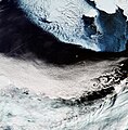
English: The Copernicus Sentinel-3A satellite brings us over the Bering Sea, north of the Alaska Peninsula, on 26 March.

Seasonal sea ice dominates the upper part of the image. Ice plays an important role in the sea’s ecosystem. Growing algae attach to the bottom of the ice; when the ice melts in the spring, it leaves behind a layer of nutrient-rich freshwater on which the algae thrive. Organisms higher up the food chain then eat the algae. In the top-right corner, we can see part of Alaska’s mainland blanketed with snow, as well as Nunivak Island appearing like a massive piece of floating ice. At the centre of the image are the islands of Saint Paul and Saint George – part of the Pribilof Islands. An estimated two million seabirds nest on these islands annually. The swirling clouds on the right side of the image are the result of a meteorological phenomenon known as a von Kármán vortex street. As wind-driven clouds pass over the Unimak Island on the right edge of the image, they flow around the high volcanoes to form the large spinning eddies that can clearly be seen in the image.

This image, also featured on the Earth from Space video programme, was captured by Sentinel-3’s Ocean and Land Colour Instrument, which helps monitor ocean ecosystems, supports crop management and agriculture, and provides estimates of atmospheric aerosol and clouds.
תאריך יצירה
מקור http://www.esa.int/spaceinimages/Images/2017/04/Bering_Sea
יוצר European Space Agency
אישורים והיתרים
(שימוש חוזר בקובץ זה)
contains modified Copernicus Sentinel data (2017), processed by ESA ,CC BY-SA 3.0 IGO
גרסאות אחרות
Title
InfoField
Bering Sea
System
InfoField
Copernicus
Keywords
InfoField
Sea-ice; Snow; Satellite image; Vortex; Weather systems
Set
InfoField
Earth observation image of the week
Mission
InfoField
Sentinel-3
Activity
InfoField
Observing the Earth

רישיון

w:he:Creative Commons
ייחוס שיתוף זהה
הנכם רשאים:
  • לשתף – להעתיק, להפיץ ולהעביר את העבודה
  • לערבב בין עבודות – להתאים את העבודה
תחת התנאים הבאים:
  • ייחוס – יש לתת ייחוס הולם, לתת קישור לרישיון, ולציין אם נעשו שינויים. אפשר לעשות את זה בכל צורה סבירה, אבל לא בשום צורה שמשתמע ממנה שמעניק הרישיון תומך בך או בשימוש שלך.
  • שיתוף זהה – אם תיצרו רמיקס, תשנו, או תבנו על החומר, חובה עליכם להפיץ את התרומות שלך לפי תנאי רישיון זהה או תואם למקור.

כיתובים

נא להוסיף משפט שמסביר מה הקובץ מייצג

פריטים שמוצגים בקובץ הזה

מוצג

image/jpeg

checksum אנגלית

1dfaae4eca3a46923e9b6c0bee74b2decda2a72b

הוגדר לפי: SHA-1 אנגלית

10,373,538 בית

3,955 פיקסל

3,903 פיקסל

היסטוריית הקובץ

ניתן ללחוץ על תאריך/שעה כדי לראות את הקובץ כפי שנראה באותו זמן.

תאריך/שעהתמונה ממוזערתממדיםמשתמשהערה
נוכחית18:06, 12 במאי 2017תמונה ממוזערת לגרסה מ־18:06, 12 במאי 2017‪3,955 × 3,903‬ (9.89 מ"ב)YannHR from TIFF, 98% compression
15:36, 6 במאי 2017תמונה ממוזערת לגרסה מ־15:36, 6 במאי 2017‪1,920 × 1,894‬ (3.27 מ"ב)European Space Agency, Id 376705, http://www.esa.int/spaceinimages/Images/2017/04/Bering_Sea, User:Fæ/Project_list/ESA

הדף הבא משתמש בקובץ הזה:

שימוש גלובלי בקובץ

אתרי הוויקי השונים הבאים משתמשים בקובץ זה: