
קובץ:C71192s1 Ant.Map Ebbe Glacier.jpg
גודל התצוגה המקדימה הזאת: 643 × 600 פיקסלים. רזולוציות אחרות: 257 × 240 פיקסלים | 515 × 480 פיקסלים | 823 × 768 פיקסלים | 1,098 × 1,024 פיקסלים | 2,196 × 2,048 פיקסלים | 3,507 × 3,271 פיקסלים.
לקובץ המקורי (3,507 × 3,271 פיקסלים, גודל הקובץ: 1.71 מ"ב, סוג MIME: image/jpeg)
| זהו קובץ שמקורו במיזם ויקישיתוף. תיאורו בדף תיאור הקובץ המקורי (בעברית) מוצג למטה. |
תקציר
| תיאור |
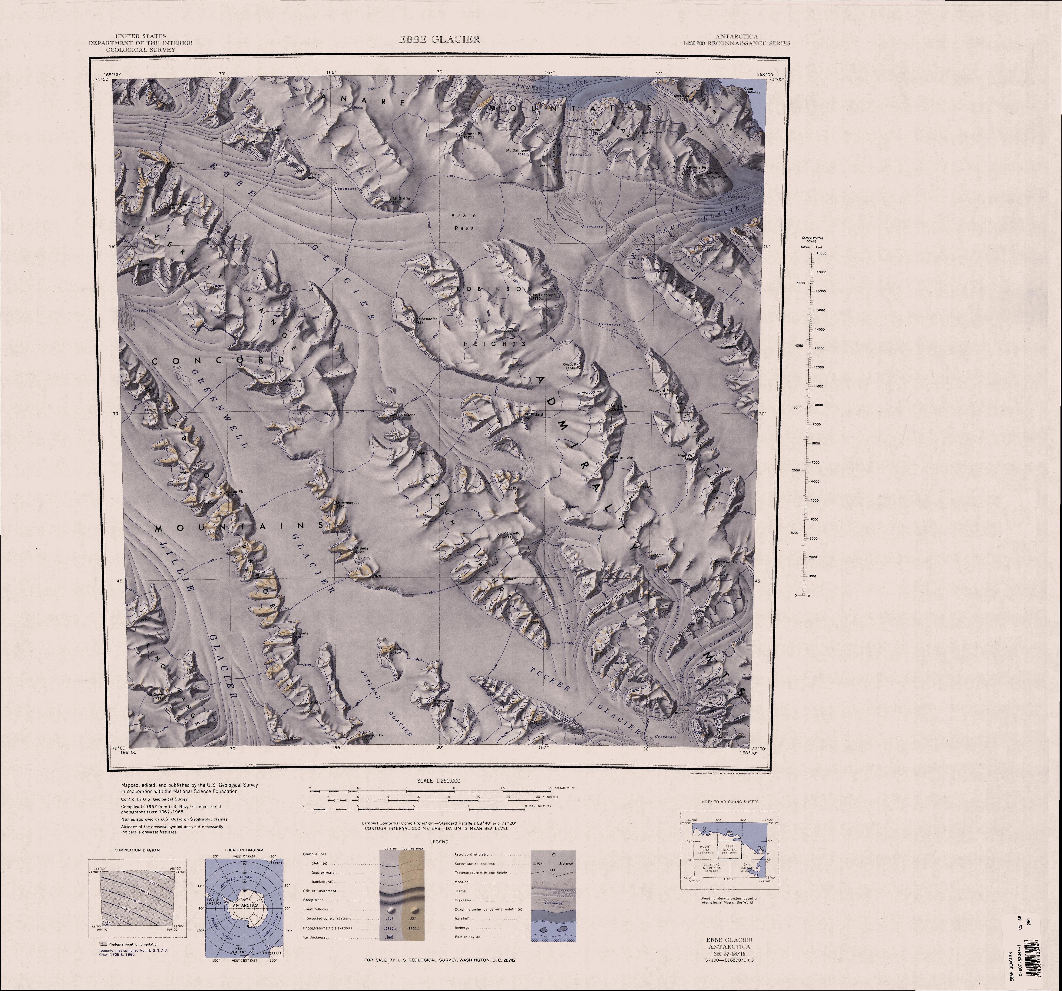
English: 1:250,000-scale topographic reconnaissance map of the Ebbe Glacier area in the Admiralty Range from 165°-168°E to 71°-72°S in Antarctica, including Greenwell, Lillie and Tucker Glacier. Mapped, edited and published by the U.S. Geological Survey in cooperation with the National Science Foundation. |
|||
| תאריך יצירה | ||||
| מקור | http://usarc.usgs.gov/drg_dload.shtml | |||
| יוצר | United States Geological Survey | |||
| אישורים והיתרים (שימוש חוזר בקובץ זה) |
|
היסטוריית הקובץ
ניתן ללחוץ על תאריך/שעה כדי לראות את הקובץ כפי שנראה באותו זמן.
| תאריך/שעה | תמונה ממוזערת | ממדים | משתמש | הערה | |
|---|---|---|---|---|---|
| נוכחית | 23:31, 3 באפריל 2005 | | 3,271 × 3,507 (1.71 מ"ב) | Achim Raschka | Map of Antarctica by the United States Antarctic Ressource Center of the US Geological Society. {{PD-US}} Copyrights and Trademarks USGS-authored or produced data and information are in the public domain. While the content of most USGS web pages is in th |
שימוש בקובץ
הדף הבא משתמש בקובץ הזה:
שימוש גלובלי בקובץ
אתרי הוויקי השונים הבאים משתמשים בקובץ זה:
- שימוש באתר bg.wikipedia.org
- שימוש באתר ceb.wikipedia.org
- שימוש באתר de.wikipedia.org
- שימוש באתר en.wikipedia.org
- Admiralty Mountains
- Dennistoun Glacier
- Everett Range
- Lyttelton Range
- Dunedin Range
- Homerun Range
- Anare Mountains
- Lillie Glacier
- Concord Mountains
- Mirabito Range
- King Range (Antarctica)
- Tucker Glacier
- Victory Mountains
- Quam Heights
- Barnett Glacier
- Findlay Range
- Hedgpeth Heights
- Robinson Heights
- McGregor Range (Antarctica)
- שימוש באתר it.wikipedia.org