
קובץ:COVID-19 Outbreak Cases in New Zealand (DHB Totals).svg

גודל התצוגה המקדימה הזאת מסוג PNG של קובץ ה־SVG הזה: 460 × 599 פיקסלים. רזולוציות אחרות: 184 × 240 פיקסלים | 369 × 480 פיקסלים | 590 × 768 פיקסלים | 787 × 1,024 פיקסלים | 1,573 × 2,048 פיקסלים | 650 × 846 פיקסלים.
לקובץ המקורי (קובץ SVG, הגודל המקורי: 650 × 846 פיקסלים, גודל הקובץ: 138 ק"ב)
| זהו קובץ שמקורו במיזם ויקישיתוף. תיאורו בדף תיאור הקובץ המקורי (בעברית) מוצג למטה. |
.svg)
.svg?uselang=he)
תקציר

|
This file may be updated to reflect new information. If you wish to use a specific version of the file without new updates being mirrored, please upload the required version as a separate file. |
| תיאור |
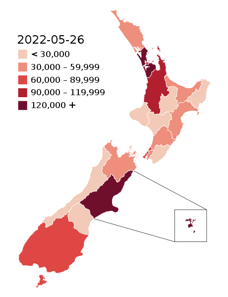
English: Map of the COVID-19 outbreak in New Zealand with case totals by District Health Board (DHB) as of 28 February 2022. Be aware that since this is a rapidly evolving situation, new cases may not be immediately represented visually. Refer to the primary article 2019–20 coronavirus outbreak by country and territory or the World Health Organization's situation reports for most recent reported case information.
The data ranges for each colour may be updated periodically to reflect changing data. Numerical ranges for each colour are calculated to give equally sized ranges. N.B: Stewart Island and Chatham Island are associated with the Southern DHB and Canterbury DHB (respectively). The colours for those islands represent the overall DHB case numbers, not the number of cases present on those islands specifically. |
| תאריך יצירה | |
| מקור |
|
| יוצר |
Base map: Base map: Stats NZ, edits by Air55 Colourisation: multiple authors |
.svg)
רישיון
הקובץ הזה מתפרסם לפי תנאי רישיון קריאייטיב קומונז ייחוס-שיתוף זהה 4.0 בין־לאומי.
- הנכם רשאים:
- לשתף – להעתיק, להפיץ ולהעביר את העבודה
- לערבב בין עבודות – להתאים את העבודה
- תחת התנאים הבאים:
- ייחוס – יש לתת ייחוס הולם, לתת קישור לרישיון, ולציין אם נעשו שינויים. אפשר לעשות את זה בכל צורה סבירה, אבל לא בשום צורה שמשתמע ממנה שמעניק הרישיון תומך בך או בשימוש שלך.
- שיתוף זהה – אם תיצרו רמיקס, תשנו, או תבנו על החומר, חובה עליכם להפיץ את התרומות שלך לפי תנאי רישיון זהה או תואם למקור.
היסטוריית הקובץ
ניתן ללחוץ על תאריך/שעה כדי לראות את הקובץ כפי שנראה באותו זמן.
.svg&dir=prev)
.svg&offset=20220129003640)
.svg&offset=&limit=20)
.svg&offset=&limit=50)
.svg&offset=&limit=100)
.svg&offset=&limit=250)
.svg&offset=&limit=500)
| תאריך/שעה | תמונה ממוזערת | ממדים | משתמש | הערה | |
|---|---|---|---|---|---|
| נוכחית | 06:55, 26 במאי 2022 | | 846 × 650 (138 ק"ב) | Air55 | Updated totals as of 26 May 2022 |
| 05:25, 3 באפריל 2022 |  | 846 × 650 (138 ק"ב) | Air55 | updated totals as of 2 April 2022 | |
| 10:47, 17 במרץ 2022 |  | 846 × 650 (138 ק"ב) | Air55 | updated totals | |
| 03:48, 8 במרץ 2022 |  | 846 × 650 (138 ק"ב) | Air55 | case totals + scale update | |
| 05:16, 6 במרץ 2022 |  | 846 × 650 (138 ק"ב) | Air55 | updated case totals | |
| 04:42, 2 במרץ 2022 |  | 846 × 650 (138 ק"ב) | Air55 | updated ranges | |
| 04:09, 2 במרץ 2022 |  | 846 × 650 (138 ק"ב) | Air55 | 02 March 2022 totals | |
| 07:43, 1 במרץ 2022 |  | 846 × 650 (138 ק"ב) | Air55 | Redid map. Legend now features in map for ease of updating across all pages, colour bins updated | |
| 06:06, 1 במרץ 2022 |  | 846 × 650 (135 ק"ב) | Air55 | updated as of 28 Feb. will be looking at making a new version of this map in light of the rapidly rising cases | |
| 03:36, 29 בינואר 2022 |  | 846 × 650 (135 ק"ב) | Air55 | Updated case totals for 28 January 2022. Colours changed for BOP, Lakes, and Canterbury DHBs. |
שימוש בקובץ
הדף הבא משתמש בקובץ הזה:
שימוש גלובלי בקובץ
אתרי הוויקי השונים הבאים משתמשים בקובץ זה:
- שימוש באתר de.wikipedia.org
- שימוש באתר en.wikipedia.org
- שימוש באתר es.wikipedia.org
- שימוש באתר fa.wikipedia.org
- שימוש באתר fr.wikipedia.org
- שימוש באתר id.wikipedia.org
- שימוש באתר ko.wikipedia.org
- שימוש באתר ms.wikipedia.org
- שימוש באתר nl.wikipedia.org
- שימוש באתר ru.wikipedia.org
- שימוש באתר simple.wikipedia.org
- שימוש באתר sq.wikipedia.org
- שימוש באתר th.wikipedia.org
- שימוש באתר uk.wikipedia.org
- שימוש באתר uz.wikipedia.org
- שימוש באתר vi.wikipedia.org
- שימוש באתר zh-yue.wikipedia.org
- שימוש באתר zh.wikipedia.org
.svg)