
קובץ:California Disaster Areas, 1964.svg

גודל התצוגה המקדימה הזאת מסוג PNG של קובץ ה־SVG הזה: 358 × 599 פיקסלים. רזולוציות אחרות: 143 × 240 פיקסלים | 287 × 480 פיקסלים | 459 × 768 פיקסלים | 612 × 1,024 פיקסלים | 1,223 × 2,048 פיקסלים | 512 × 857 פיקסלים.
לקובץ המקורי (קובץ SVG, הגודל המקורי: 512 × 857 פיקסלים, גודל הקובץ: 741 ק"ב)
| זהו קובץ שמקורו במיזם ויקישיתוף. תיאורו בדף תיאור הקובץ המקורי (בעברית) מוצג למטה. |
| תיאור |
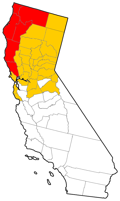
English: Vector outline map of California showing counties affected by the Christmas flood of 1964. The thirty-four colored counties were all declared disaster areas, and the six red counties sustained more damage than the other twenty-eight combined. Derived from a United States Census publication. |
| תאריך יצירה | (UTC) |
| מקור | |
| יוצר |
|
| זוהי תמונה מרוטשת, זאת אומרת שהתמונה שונתה בצורה דיגיטלית מהמקור. Modifications: Colored for use on the Christmas flood of 1964 article. את התמונה המקורית ניתן לראות ב: California counties outline map.svg. השינוי בוצע על ידי Little Mountain 5.
|
This image or file is a work of a United States Census Bureau employee, taken or made as part of that person's official duties. As a work of the U.S. federal government, the image is in the public domain.
|
 |
יומן העלאה מקורי
This image is a derivative work of the following images:
- File:California_counties_outline_map.svg licensed with PD-USGov-DOC-Census
- 2009-09-17T18:30:56Z Babbage 512x857 (685516 Bytes) {{Information |Description=Vector outline map of California showing state and county borders. Derived from a US Census publication. |Source=*[[:File:California_county_map.svg|]] |Date=2009-09-17 18:28 (UTC) |Author=*[[:File:C
Uploaded with derivativeFX
היסטוריית הקובץ
ניתן ללחוץ על תאריך/שעה כדי לראות את הקובץ כפי שנראה באותו זמן.
| תאריך/שעה | תמונה ממוזערת | ממדים | משתמש | הערה | |
|---|---|---|---|---|---|
| נוכחית | 01:07, 1 באוגוסט 2011 | | 857 × 512 (741 ק"ב) | Little Mountain 5 | Attempt to clean up some. |
| 04:33, 29 ביולי 2011 |  | 857 × 512 (751 ק"ב) | Little Mountain 5 | {{Information |Description={{en|1=Vector outline map of California showing counties affected by the Christmas flood of 1964. The thirty-four colored counties were all declared disaster areas, and the six red counties sustai |
שימוש בקובץ
הדף הבא משתמש בקובץ הזה:
שימוש גלובלי בקובץ
אתרי הוויקי השונים הבאים משתמשים בקובץ זה:
- שימוש באתר en.wikipedia.org