
קובץ:California Map.PNG
אין גרסה ברזולוציה גבוהה יותר.
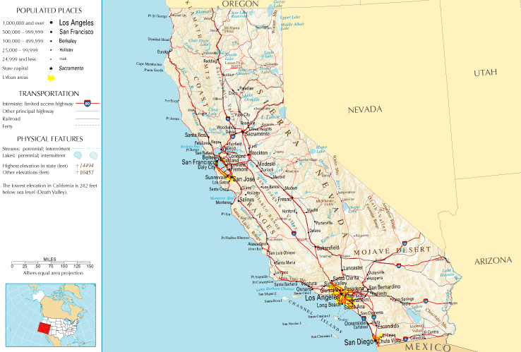
California_Map.PNG (738 × 499 פיקסלים, גודל הקובץ: 83 ק"ב, סוג MIME: image/png)
| זהו קובץ שמקורו במיזם ויקישיתוף. תיאורו בדף תיאור הקובץ המקורי (בעברית) מוצג למטה. |
תקציר
| תיאור | |
| תאריך יצירה | |
| מקור | |
| יוצר | National Atlas of the United States |
| אישורים והיתרים (שימוש חוזר בקובץ זה) |
Public domain |
רישיון
This map was obtained from an edition of the National Atlas of the United States. Like almost all works of the U.S. federal government, works from the National Atlas are in the public domain in the United States.
Online access: NationalAtlas.gov | 1970 print edition: Library of Congress, Perry-Castañeda Library
|
היסטוריית הקובץ
ניתן ללחוץ על תאריך/שעה כדי לראות את הקובץ כפי שנראה באותו זמן.
| תאריך/שעה | תמונה ממוזערת | ממדים | משתמש | הערה | |
|---|---|---|---|---|---|
| נוכחית | 16:45, 10 ביולי 2011 | | 499 × 738 (83 ק"ב) | Quibik | Cropped the frame as it is not really necessary. |
| 15:14, 28 בינואר 2006 |  | 587 × 764 (95 ק"ב) | Severino666~commonswiki | Image from the National Atlas of the United States |
שימוש בקובץ
![]() אין בוויקיפדיה דפים המשתמשים בקובץ זה.
אין בוויקיפדיה דפים המשתמשים בקובץ זה.
שימוש גלובלי בקובץ
אתרי הוויקי השונים הבאים משתמשים בקובץ זה:
- שימוש באתר ca.wikipedia.org
- שימוש באתר en.wikipedia.org
- שימוש באתר fr.wikipedia.org
- שימוש באתר he.wikivoyage.org
- שימוש באתר hr.wiktionary.org
- שימוש באתר mr.wikipedia.org