
קובץ:Central europe 1572.png
גודל התצוגה המקדימה הזאת: 628 × 599 פיקסלים. רזולוציות אחרות: 251 × 240 פיקסלים | 503 × 480 פיקסלים | 922 × 880 פיקסלים.
לקובץ המקורי (922 × 880 פיקסלים, גודל הקובץ: 120 ק"ב, סוג MIME: image/png)
| זהו קובץ שמקורו במיזם ויקישיתוף. תיאורו בדף תיאור הקובץ המקורי (בעברית) מוצג למטה. |
תקציר
| תיאור |
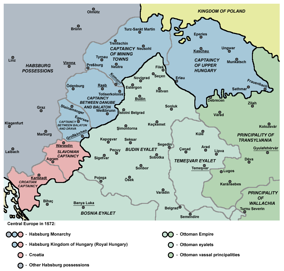
English: Captaincies of the Kingdom of Hungary in 1572: Habsburg Hungary (Royal Hungary), Habsburg Slavonia, Habsburg Croatia, Ottoman Budin Eyalet, Ottoman Temeşvar Eyalet. |
| תאריך יצירה | |
| מקור | נוצר על־ידי מעלה היצירה |
| יוצר | PANONIAN |
| גרסאות אחרות |
|

רישיון
אני, בעל זכויות היוצרים על עבודה זו, מפרסם בזאת את העבודה תחת הרישיון הבא:
| קובץ זה זמין לפי תנאי הקדשה עולמית לנחלת הכלל CC0 1.0 של Creative Commons. | |
| האדם ששייך יצירה להיתר הזה הקדיש את היצירה לנחלת הכלל על־ידי ויתור על כל הזכויות שלו או שלה על היצירה בכל העולם לפי חוק זכויות יוצרים, לרבות כל הזכויות הקשורות או הסמוכות כקבוע בחוק. באפשרותך להעתיק, לשנות, להפיץ, או להציג את היצירה, אפילו למטרות מסחריות, וכל זה אפילו מבלי לבקש רשות.
|
References
- http://www.sulinet.hu/eletmod/hogyantovabb/tovabbtanulas/elokeszito/tortenelem/6het/map.jpg
- http://honismeret.uw.hu/pictures/history/oszman_torok_birodalom_big.jpg archive copy at the Wayback Machine
- http://www.kepido.oszk.hu/attachments/images/nagy/pe94122.jpg
- http://mek.niif.hu/01800/01885/html/cd5m/kepek/nyelvtortenet/ny251pe94122.jpg
- http://mek.oszk.hu/01800/01885/html/cd5m/kepek/c4341pe94122.jpg
- http://mek.oszk.hu/01800/01885/html/cd5m/kepek/tortenelem/to321pe94123b.jpg
- http://hu.wikipedia.org/wiki/Fájl:Torokvilag.jpg[dead link]
- http://www.sulinet.hu/oroksegtar/data/telepulesek_ertekei/Erd/pages/images/221.jpg
- http://xxlworld.xx.ohost.de/povijest/slike/mape/1606.jpg
- http://www.hic.hr/books/pavlicev/images/s05.gif archive copy at the Wayback Machine
- The Times History of Europe, Times Books, London, 2002.
- Peter Rokai - Zoltan Đere - Tibor Pal - Aleksandar Kasaš, Istorija Mađara, Beograd, 2002.
- Dr Dušan J. Popović, Srbi u Vojvodini, knjiga 1, Novi Sad, 1990.
- Dr D. J. Popović, Vojvodina u tursko doba, Zbornik "Vojvodina", knjiga I, Fototipsko izdanje, PROMETEJ, Novi Sad, 2008.
- Halil Inaldžik, Osmansko carstvo, Beograd, 2003.
היסטוריית הקובץ
ניתן ללחוץ על תאריך/שעה כדי לראות את הקובץ כפי שנראה באותו זמן.
| תאריך/שעה | תמונה ממוזערת | ממדים | משתמש | הערה | |
|---|---|---|---|---|---|
| נוכחית | 13:36, 5 בספטמבר 2011 | | 880 × 922 (120 ק"ב) | PANONIAN | {{Information |Description ={{en|1=Map of Central Europe in 1572: Habsburg Kingdom of Hungary (Royal Hungary), Habsburg Croatia, Ottoman Budin Eyalet, Ottoman Temeşvar Eyalet. }} |Source ={{own}} |Author =PANONIAN |Da |
שימוש בקובץ
הדפים הבאים משתמשים בקובץ הזה:
שימוש גלובלי בקובץ
אתרי הוויקי השונים הבאים משתמשים בקובץ זה:
- שימוש באתר ar.wikipedia.org
- שימוש באתר be.wikipedia.org
- שימוש באתר bg.wikipedia.org
- שימוש באתר bs.wikipedia.org
- שימוש באתר cs.wikipedia.org
- שימוש באתר de.wikipedia.org
- שימוש באתר el.wikipedia.org
- שימוש באתר en.wikipedia.org
- Burgenland
- List of administrative divisions of the Kingdom of Hungary
- Kingdom of Hungary (1526–1867)
- Upper Hungary
- Talk:Upper Hungary
- Ottoman Hungary
- Budin Eyalet
- Captaincies of the Kingdom of Hungary
- Eparchy of Marča
- Transformation of the Ottoman Empire
- User:Falcaorib
- Palanka (fortification)
- Wikipedia:Graphics Lab/Map workshop/Archive/Mar 2023
- שימוש באתר eo.wikipedia.org
- שימוש באתר es.wikipedia.org
- שימוש באתר et.wikipedia.org
- שימוש באתר fa.wikipedia.org
- שימוש באתר fr.wikipedia.org
- שימוש באתר hr.wikipedia.org
- שימוש באתר hu.wikipedia.org