
קובץ:Cities of Tierra del Fuego.png
אין גרסה ברזולוציה גבוהה יותר.
Cities_of_Tierra_del_Fuego.png (519 × 475 פיקסלים, גודל הקובץ: 21 ק"ב, סוג MIME: image/png)
| זהו קובץ שמקורו במיזם ויקישיתוף. תיאורו בדף תיאור הקובץ המקורי (בעברית) מוצג למטה. |
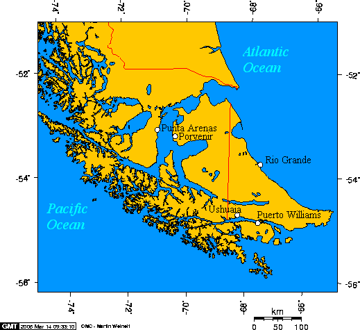
English: Cities of Tierra del Fuego
Esperanto: Urboj de Fuegio
Español: Ciudades de Tierra del Fuego

|
מוענקת בכך הרשות להעתיק, להפיץ או לשנות את המסמך הזה, לפי תנאי הרישיון לשימוש חופשי במסמכים של גנו, גרסה 1.2 או כל גרסה מאוחרת יותר שתפורסם על־ידי המוסד לתוכנה חופשית; ללא פרקים קבועים, ללא טקסט עטיפה קדמית וללא טקסט עטיפה אחורית. עותק של הרישיון כלול בפרק שכותרתו הרישיון לשימוש חופשי במסמכים של גנו. |
| הקובץ הזה מתפרסם לפי תנאי רישיון קריאייטיב קומונז ייחוס-שיתוף זהה 3.0 לא מותאם. | ||
| ||
| תבנית רישוי זו הוספה לקובץ כחלק מעדכון רישיון GFDL. |
This map is taken from en:Image:Cities of Tierra del Fuego.png and was created with this online map creation tool archive copy at the Wayback Machine. Uploaded by en:User:Geo Swan on 14 March 2005.
The longitude and latitude of the cities follow:
- -70.9333,-53.1666,Punta Arenas
- -70.3648,-53.2959,Porvenir
- -67.6167,-54.9333,Puerto Williams
- -68.2978,-54.7921,Ushuaia
- -67.5982,-53.8114,Rio Grande
היסטוריית הקובץ
ניתן ללחוץ על תאריך/שעה כדי לראות את הקובץ כפי שנראה באותו זמן.
| תאריך/שעה | תמונה ממוזערת | ממדים | משתמש | הערה | |
|---|---|---|---|---|---|
| נוכחית | 14:47, 6 באוקטובר 2005 | | 475 × 519 (21 ק"ב) | ChongDae | This image was copied from wikipedia:en. The original description was: Cities of Tierra del Fuego {{GFDL}} This map was created with this [http://www.aquarius.geomar.de/omc/ online map creation tool]. The longitude and latitude of the cities follow: *- |
| 13:46, 24 באפריל 2005 |  | 475 × 519 (21 ק"ב) | Poulpy | Cities of Tierra del Fuego {{GFDL}} This map is taken from en:Image:Cities of Tierra del Fuego.png and was created with this [http://www.aquarius.geomar.de/omc/ online map creation tool]. The longitude and latitude of the cities follow: *-70.9333,- |
שימוש בקובץ
![]() אין בוויקיפדיה דפים המשתמשים בקובץ זה.
אין בוויקיפדיה דפים המשתמשים בקובץ זה.
שימוש גלובלי בקובץ
אתרי הוויקי השונים הבאים משתמשים בקובץ זה:
- שימוש באתר ar.wikipedia.org
- שימוש באתר bg.wikipedia.org
- שימוש באתר ca.wikipedia.org
- שימוש באתר ckb.wikipedia.org
- שימוש באתר cs.wikipedia.org
- שימוש באתר da.wikipedia.org
- שימוש באתר de.wikipedia.org
- שימוש באתר el.wikipedia.org
- שימוש באתר en.wikipedia.org
- שימוש באתר eo.wikipedia.org
- שימוש באתר es.wikipedia.org
- שימוש באתר fa.wikipedia.org
- שימוש באתר fr.wikipedia.org
- שימוש באתר fy.wikipedia.org
- שימוש באתר gd.wikipedia.org
- שימוש באתר hr.wikipedia.org
- שימוש באתר id.wikipedia.org
- שימוש באתר it.wikipedia.org
- שימוש באתר ja.wikipedia.org
- שימוש באתר ka.wikipedia.org
- שימוש באתר ko.wikipedia.org
- שימוש באתר la.wikipedia.org
- שימוש באתר lt.wikipedia.org
- שימוש באתר mk.wikipedia.org
- שימוש באתר ml.wikipedia.org
- שימוש באתר nl.wikipedia.org
- שימוש באתר no.wikipedia.org
- שימוש באתר pl.wikipedia.org
- שימוש באתר pl.wiktionary.org
- שימוש באתר pt.wikipedia.org
- שימוש באתר ro.wikipedia.org