
קובץ:Colonisation 2007.png

לקובץ המקורי (1,425 × 625 פיקסלים, גודל הקובץ: 44 ק"ב, סוג MIME: image/png)
| זהו קובץ שמקורו במיזם ויקישיתוף. תיאורו בדף תיאור הקובץ המקורי (בעברית) מוצג למטה. |
| תיאור |
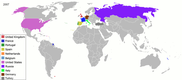
Map of major world powers by year, derived from public domain animated map on wikipedia.
As the orriginal licence of the animation was Public Domain, this image which has been derived from it is too:
|
||||||||||||||||||
| תאריך יצירה | |||||||||||||||||||
| מקור | public domain animated map by ArdadN here | ||||||||||||||||||
| יוצר | ArdadN | ||||||||||||||||||
.jpg)
._LOC_2001620596.jpg)

|
יש ליצור מחדש את התמונה historical map הזו באמצעות גרפיקה וקטורית כדוגמת קובץ SVG. לפעולה זו מספר יתרונות, כפי שניתן לקרוא (באנגלית) בדף Commons:Media for cleanup. אם ברשותכם קובץ SVG, אנא העלו אותו. לאחר מכן, החליפו תבנית זו בתבנית
{{vector version available|שם הקובץ.svg}} |
היסטוריית הקובץ
ניתן ללחוץ על תאריך/שעה כדי לראות את הקובץ כפי שנראה באותו זמן.
| תאריך/שעה | תמונה ממוזערת | ממדים | משתמש | הערה | |
|---|---|---|---|---|---|
| נוכחית | 01:06, 1 במרץ 2019 | | 625 × 1,425 (44 ק"ב) | Nioktest | Coloration en bleu de Mayotte et de La Réunion, départements de l'état français. |
| 04:51, 22 במאי 2010 |  | 625 × 1,425 (75 ק"ב) | Kieran4 | Add Aruba and Curacao | |
| 20:31, 3 במאי 2008 |  | 625 × 1,425 (56 ק"ב) | SelfQ~commonswiki | {{Information |Description= |Source= |Date= |Author= |Permission= |other_versions= }} | |
| 13:41, 22 במרץ 2007 |  | 625 × 1,425 (65 ק"ב) | Roke~commonswiki | {{Information |Description=Map of major world powers by year, derived from public domain animated map on wikipedia. {{Maps of world history}} As the orriginal licence of the animation was Public Domain, this image which has been derived from it is too: { |
שימוש בקובץ
![]() אין בוויקיפדיה דפים המשתמשים בקובץ זה.
אין בוויקיפדיה דפים המשתמשים בקובץ זה.
שימוש גלובלי בקובץ
אתרי הוויקי השונים הבאים משתמשים בקובץ זה:
- שימוש באתר en.wikipedia.org
- שימוש באתר fr.wikipedia.org
- שימוש באתר oc.wikipedia.org
- שימוש באתר vi.wikipedia.org