
קובץ:CountriesRecognizingKosovo.svg

גודל התצוגה המקדימה הזאת מסוג PNG של קובץ ה־SVG הזה: 800 × 349 פיקסלים. רזולוציות אחרות: 320 × 139 פיקסלים | 640 × 279 פיקסלים | 1,024 × 446 פיקסלים | 1,280 × 558 פיקסלים | 2,560 × 1,115 פיקסלים | 2,754 × 1,200 פיקסלים.
לקובץ המקורי (קובץ SVG, הגודל המקורי: 2,754 × 1,200 פיקסלים, גודל הקובץ: 1.11 מ"ב)
| זהו קובץ שמקורו במיזם ויקישיתוף. תיאורו בדף תיאור הקובץ המקורי (בעברית) מוצג למטה. |

תקציר
| תיאור |
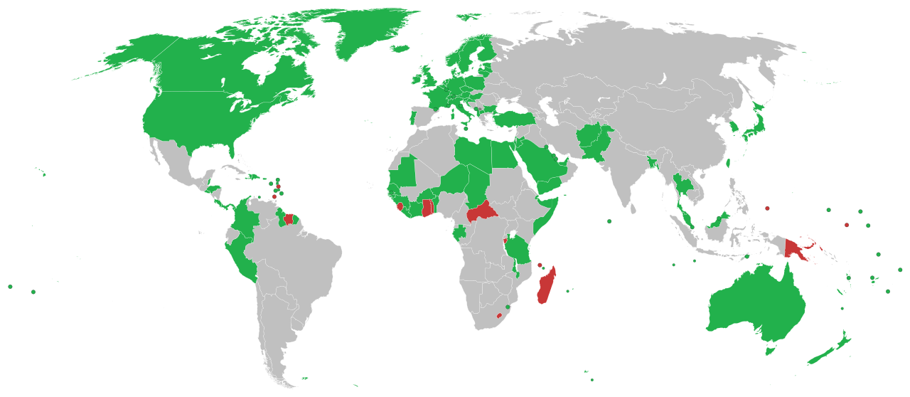
English: This is a map of countries recognizing independence of Kosovo
Recognise Kosovo as independent #808080 #C83737ff Withdrawn Hrvatski: Ovo je karta koja prikazuje države koje su priznale neovisnost Kosova
Priznaju neovisnost Kosova #808080 Español: Mapa de los países que reconocen la independencia de Kosovo
Deutsch: Länder in Grün erkennen den Kosovo als unabhängigen Staat an. Länder in rot haben die Anerkennung zurückgezogen.
Italiano: Mappa dei paesi che hanno riconosciuto l'indipendenza del Kosovo.
Português: Mapa dos países que reconhecem a independência do Kosovo.
Română: Aceasta este o hartă care arată recunoașterea independenței Republicii Kosovo pe plan internațional
Svenska: En karta över länder som formellt erkänner Kosovos självständighetsförklaring
Formellt erkänner Kosovos självständighetsförklaring #808080 #C83737ff Återkallat Türkçe: Kosova'nın bağımsızlığını tanıyan ülkelerin haritası
Українська: Карта країн, що визнають незалежність Косова.
العربية: هذه خريطة الدول التي تعترف بكوسوفو كدولة مستقلة الدول التي تعترف بكوسوفو كدولة مستقلة #808080 #C83737ff #CCCCCC الدول |
| תאריך יצירה |
17 בספטמבר 2008 (תאריך העלאה מקורי) |
| מקור |
English Wikipedia http://en.wikipedia.org/wiki/Image:CountriesRecognizingKosovo.png (טקסט מקורי: “March-May 2008 and ongoing”) |
| יוצר |
Alethiareg, ArturM, Balfabio, Avala, Mareklug, Cradel, Gugganij, Husond, en, Zscout370, en, Chech Explorer, Camptown, Hoshie, Nightstallion, Ijanderson977 / מעלה היצירה המקורי היה Alethiareg מוויקיפדיה האנגלית |
| גרסאות אחרות | CountriesRecognizingKosovo.png |
| SVGהתפתחות | Other tools עם נוצרה ה גרפיקה וקטורית |
רישיון
| היצירה הזאת שוחררה לנחלת הכלל על־ידי היוצר שלה, Alethiareg מוויקיפדיה האנגלית. זה תקף בכל העולם. יש מדינות שבהן הדבר אינו אפשרי על פי חוק, אם כך: Alethiareg מעניק לכל אחד את הזכות להשתמש ביצירה הזאת לכל מטרה, ללא שום תנאי, אלא אם כן תנאים כאלה נדרשים לפי החוק. |
יומן העלאה מקורי
הועבר מ- en.wikipedia לוויקישיתוףעל ידי EmilJ באמצעות CommonsHelper.
תיאור הקובץ המקורי נמצא כאן. כל שמות המשתמשים הבאים מתייחסים ל-en.wikipedia.
- 14:22, 17 September 2008 940×415 (1.45 MB) EmilJ add Taiwan, omit circles for dependent territories
- 11:46, 16 September 2008 940×415 (1.45 MB) EmilJ Samoa recognized
- 14:20, 15 September 2008 940×415 (1.45 MB) EmilJ use CSS, add missing countries and territories
- 09:39, 15 September 2008 940×415 (1.49 MB) Alethiareg == Summary == {{Information |Description=This is a map of countries recognizing independence of Kosovo. |Author =User:Alethiareg, User:ArturM, User:Balfabio, [[User:Av
היסטוריית הקובץ
ניתן ללחוץ על תאריך/שעה כדי לראות את הקובץ כפי שנראה באותו זמן.
| תאריך/שעה | תמונה ממוזערת | ממדים | משתמש | הערה | |
|---|---|---|---|---|---|
| נוכחית | 02:54, 2 בינואר 2022 | | 1,200 × 2,754 (1.11 מ"ב) | Kwamikagami | color integral constituents (Puerto Rico, New Caledonia, etc.) |
| 00:23, 27 באפריל 2021 |  | 1,200 × 2,754 (1.05 מ"ב) | NordNordWest | Reverted to version as of 06:02, 25 February 2021 (UTC) | |
| 19:58, 25 באפריל 2021 |  | 223 × 512 (805 ק"ב) | ויקי4800 | תיקון גבולות מדינת ישראל | |
| 09:02, 25 בפברואר 2021 |  | 1,200 × 2,754 (1.05 מ"ב) | Liggliluff | Replacing file with BlankMap-World.svg for a better look, countries coloured by the style-code, should be correct to the last map, the image is cropped and ocean hidden, micro-nations have circles, and hovering shows popups | |
| 02:55, 9 בפברואר 2021 |  | 750 × 1,650 (918 ק"ב) | Arianasmithy74 | Reverted to version as of 21:31, 29 December 2020 (UTC) | |
| 20:32, 7 בפברואר 2021 |  | 750 × 1,650 (918 ק"ב) | Arianasmithy74 | Comoros now sent a letter to Kosovo saying that they still recognise Kosovo | |
| 00:31, 30 בדצמבר 2020 |  | 750 × 1,650 (918 ק"ב) | Arianasmithy74 | Brunei is green again. | |
| 00:18, 30 בדצמבר 2020 |  | 750 × 1,650 (918 ק"ב) | Arianasmithy74 | Nauru is now red as it withdrew recognition. | |
| 18:41, 27 בדצמבר 2020 |  | 750 × 1,650 (918 ק"ב) | Arianasmithy74 | Brunei is now green Also, 'nu' is Niue so it is not supposed to be red | |
| 14:05, 11 בדצמבר 2020 |  | 750 × 1,650 (918 ק"ב) | Kwamikagami | withdrawn recognition |
שימוש בקובץ
![]() אין בוויקיפדיה דפים המשתמשים בקובץ זה.
אין בוויקיפדיה דפים המשתמשים בקובץ זה.
שימוש גלובלי בקובץ
אתרי הוויקי השונים הבאים משתמשים בקובץ זה:
- שימוש באתר af.wikipedia.org
- שימוש באתר ar.wikipedia.org
- שימוש באתר arz.wikipedia.org
- שימוש באתר ast.wikipedia.org
- שימוש באתר bg.wikipedia.org
- שימוש באתר bn.wikipedia.org
- שימוש באתר ca.wikipedia.org
- שימוש באתר cs.wikipedia.org
- שימוש באתר de.wikipedia.org
- Benutzer:Generator
- Geschichte des Kosovo
- Liste der Gebiete mit begrenzter Anerkennung als Staat
- Kosovo
- Portal:Kosovo/Artikel des Monats
- Diskussion:Kosovo/Archiv/005
- Internationale Anerkennung des Kosovo
- Diskussion:Kosovo/Archiv/006
- Diskussion:Internationale Anerkennung des Kosovo/Archiv
- Wikipedia:Kartenwerkstatt/Archiv/2018-03
- שימוש באתר el.wikipedia.org
- שימוש באתר en.wikipedia.org
- שימוש באתר es.wikipedia.org
- שימוש באתר fa.wikipedia.org
- שימוש באתר fi.wikipedia.org
- שימוש באתר fr.wikipedia.org
- שימוש באתר gl.wikipedia.org
- שימוש באתר hr.wikipedia.org
- שימוש באתר hu.wikipedia.org
- שימוש באתר hy.wikipedia.org
- שימוש באתר id.wikipedia.org
- שימוש באתר incubator.wikimedia.org
- שימוש באתר it.wikipedia.org