
קובץ:EU Member states and Candidate countries map.svg

גודל התצוגה המקדימה הזאת מסוג PNG של קובץ ה־SVG הזה: 701 × 599 פיקסלים. רזולוציות אחרות: 281 × 240 פיקסלים | 561 × 480 פיקסלים | 898 × 768 פיקסלים | 1,198 × 1,024 פיקסלים | 2,395 × 2,048 פיקסלים | 1,401 × 1,198 פיקסלים.
לקובץ המקורי (קובץ SVG, הגודל המקורי: 1,401 × 1,198 פיקסלים, גודל הקובץ: 860 ק"ב)
| זהו קובץ שמקורו במיזם ויקישיתוף. תיאורו בדף תיאור הקובץ המקורי (בעברית) מוצג למטה. |
תקציר
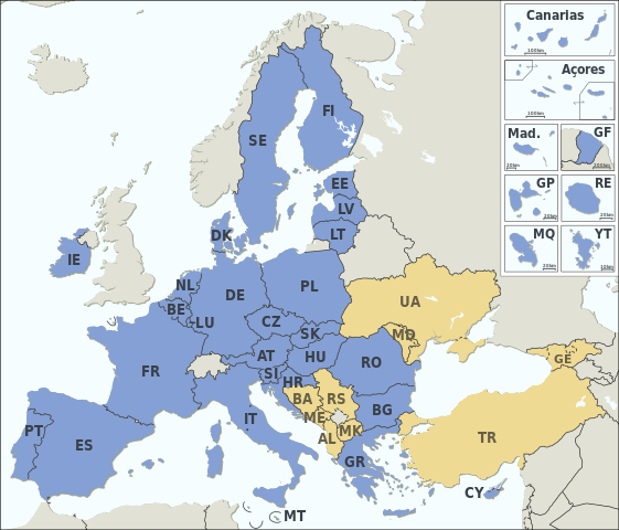
| תיאור |
Asturianu: Estaos miembros de la XE (más los países candidatos)
Català: Estats membres de la UE (més els països candidats)
Deutsch: Mitgliedstaaten der EU (+ Bewerberländer)
English: Member states of the EU (plus candidate countries)
Esperanto: Membraj ŝtatoj de EU (kaj kandidataj landoj)
Español: Estados miembros de la UE (más los países candidatos)
Français : Etats membres de l’UE (et pays candidats)
Italiano: Stati membri dell’UE (+ Paesi candidati)
Македонски: Земји членки на ЕУ (+ кандидати)
Member states of the EU Candidate countries
|
|||||||||||||||||||||||||||||||||||||||||||||||||||||||||||||||||||||||||||||||||||
| תאריך יצירה | ||||||||||||||||||||||||||||||||||||||||||||||||||||||||||||||||||||||||||||||||||||
| מקור |
Natural Earth 1:50m (http://www.naturalearthdata.com) This SVG _?_ includes elements from this _?_: This SVG _?_ includes elements from this _?_: This SVG _?_ includes elements from this _?_: This SVG _?_ includes elements from this _?_: This SVG _?_ includes elements from this _?_: This SVG _?_ includes elements from this _?_: |
|||||||||||||||||||||||||||||||||||||||||||||||||||||||||||||||||||||||||||||||||||
| יוצר | Alexrk2 | |||||||||||||||||||||||||||||||||||||||||||||||||||||||||||||||||||||||||||||||||||
| גרסאות אחרות |
|
|||||||||||||||||||||||||||||||||||||||||||||||||||||||||||||||||||||||||||||||||||
| SVGהתפתחות | Batik עם נוצרה ה W3C-לא תקין גרפיקה וקטורית ו עם Inkscape.
. GeoTools עם נוצרה ה תמונה
|


רישיון
אני, בעל זכויות היוצרים על עבודה זו, מפרסם בזאת את העבודה תחת הרישיון הבא:
הקובץ הזה מתפרסם לפי תנאי רישיון קריאייטיב קומונז ייחוס-שיתוף זהה 3.0 לא מותאם.
- הנכם רשאים:
- לשתף – להעתיק, להפיץ ולהעביר את העבודה
- לערבב בין עבודות – להתאים את העבודה
- תחת התנאים הבאים:
- ייחוס – יש לתת ייחוס הולם, לתת קישור לרישיון, ולציין אם נעשו שינויים. אפשר לעשות את זה בכל צורה סבירה, אבל לא בשום צורה שמשתמע ממנה שמעניק הרישיון תומך בך או בשימוש שלך.
- שיתוף זהה – אם תיצרו רמיקס, תשנו, או תבנו על החומר, חובה עליכם להפיץ את התרומות שלך לפי תנאי רישיון זהה או תואם למקור.
היסטוריית הקובץ
ניתן ללחוץ על תאריך/שעה כדי לראות את הקובץ כפי שנראה באותו זמן.
| תאריך/שעה | תמונה ממוזערת | ממדים | משתמש | הערה | |
|---|---|---|---|---|---|
| נוכחית | 20:11, 31 בינואר 2024 | | 1,198 × 1,401 (860 ק"ב) | Janitoalevic | Armenia-Azerbaijan update |
| 03:27, 15 בדצמבר 2023 |  | 1,198 × 1,401 (860 ק"ב) | Iktsokh | Georgia is recognized as an official candidate. | |
| 19:12, 6 בפברואר 2023 |  | 1,198 × 1,401 (860 ק"ב) | Nestrus | forgot the caption | |
| 19:07, 6 בפברואר 2023 |  | 1,198 × 1,401 (859 ק"ב) | Nestrus | +candidate Bosnia | |
| 21:58, 23 ביוני 2022 |  | 1,198 × 1,401 (845 ק"ב) | Cyygma | Ukraine and Modova confirmed as official candidates | |
| 18:13, 1 בפברואר 2020 |  | 1,198 × 1,401 (844 ק"ב) | Hansbaer | absurd argument. The map has always followed the development of the EU | |
| 17:48, 1 בפברואר 2020 |  | 1,198 × 1,401 (845 ק"ב) | Alexis Jazz | Reverted to version as of 16:53, 17 March 2015 (UTC) User:Janitoalevic needs to be uploaded as a new file | |
| 02:15, 1 בפברואר 2020 |  | 1,198 × 1,401 (844 ק"ב) | Janitoalevic | Brexit | |
| 19:53, 17 במרץ 2015 |  | 1,198 × 1,401 (845 ק"ב) | Appaches | Ukraine-Crimée : séparation pointillée | |
| 20:05, 15 במרץ 2015 |  | 1,198 × 1,401 (844 ק"ב) | Appaches | Islande retirée |
שימוש בקובץ
הדף הבא משתמש בקובץ הזה:
שימוש גלובלי בקובץ
אתרי הוויקי השונים הבאים משתמשים בקובץ זה:
- שימוש באתר ab.wikipedia.org
- שימוש באתר ar.wikipedia.org
- שימוש באתר ast.wikipedia.org
- שימוש באתר az.wikipedia.org
- שימוש באתר az.wiktionary.org
- שימוש באתר be-tarask.wikipedia.org
- שימוש באתר br.wikipedia.org
- שימוש באתר ca.wikipedia.org
- שימוש באתר cy.wikipedia.org
- שימוש באתר da.wikipedia.org
- שימוש באתר de.wikipedia.org
- Europäische Union
- Portal:Europäische Union
- Mitgliedstaaten der Europäischen Union
- Gebiet der Europäischen Union
- Vorlage:Imagemap Mitgliedstaaten der Europäischen Union
- Vorlage:Imagemap Mitgliedstaaten der Europäischen Union/Test
- Wikipedia:Kartenwerkstatt/Archiv/2011-04
- Benutzer:RickVulcan/Länder Europas
- Extrempunkte der Europäischen Union
- Benutzer:Kpfiwa/Spielwiese/Test
- Benutzer:Oesterreicher12/Spielwiese 2
- Benutzer:HudecEmil
- שימוש באתר de.wiktionary.org
- שימוש באתר ext.wikipedia.org
- שימוש באתר fiu-vro.wikipedia.org
- שימוש באתר fo.wikipedia.org
- שימוש באתר frp.wikipedia.org
- שימוש באתר fr.wikipedia.org
- Élargissement de l'Union européenne
- Droit européen
- Utilisateur:William Pedros
- Modèle:UE-EU-ISO 3166-1 530px
- Union européenne
- Futur élargissement de l'Union européenne
- Wikipédia:Atelier graphique/Cartes/Archives/mai 2014
- Wikipédia:Atelier graphique/Cartes/Archives/mars 2015
- Utilisateur:AlexisN
- Wikipédia:Atelier graphique/Cartes/Archives/août 2017
- שימוש באתר fr.wikibooks.org
- שימוש באתר fur.wikipedia.org
- שימוש באתר fy.wikipedia.org
- שימוש באתר gd.wikipedia.org
- שימוש באתר hr.wikipedia.org
- שימוש באתר hu.wikipedia.org
- שימוש באתר hy.wikipedia.org
- שימוש באתר ia.wikipedia.org
- שימוש באתר id.wikipedia.org