
קובץ:ElectoralCollege1844.svg

גודל התצוגה המקדימה הזאת מסוג PNG של קובץ ה־SVG הזה: 577 × 593 פיקסלים. רזולוציות אחרות: 234 × 240 פיקסלים | 467 × 480 פיקסלים | 747 × 768 פיקסלים | 996 × 1,024 פיקסלים | 1,993 × 2,048 פיקסלים.
לקובץ המקורי (קובץ SVG, הגודל המקורי: 577 × 593 פיקסלים, גודל הקובץ: 166 ק"ב)
| זהו קובץ שמקורו במיזם ויקישיתוף. תיאורו בדף תיאור הקובץ המקורי (בעברית) מוצג למטה. |
| U.S. presidential election maps (SVG) |
| See also: National Atlas maps (png) |
|
1789 · 1792 · 1796 · 1800 · 1804 · 1808 · 1812 · 1816 · 1820 · 1824 · 1828 · 1832 · 1836 · 1840 · 1844 · 1848 · 1852 · 1856 · 1860 · 1864 · 1868 · 1872 · 1876 · 1880 · 1884 · 1888 · 1892 · 1896 · 1900 · 1904 · 1908 · 1912 · 1916 · 1920 · 1924 · 1928 · 1932 · 1936 · 1940 · 1944 · 1948 · 1952 · 1956 · 1960 · 1964 · 1968 · 1972 · 1976 · 1980 · 1984 · 1988 · 1992 · 1996 · 2000 · 2004 · 2008 · 2012 · 2016 · 2020 · 2024 |
תקציר
| תיאור | |
| תאריך יצירה | (Original); 2009-01-24 (Current) |
| מקור | This image was adapted from File:ElectoralCollege1804.svg, itself adapted from File:Map of territorial growth 1775.svg and File:ElectoralCollege1964.svg (both based off File:Blank_US_Map.svg) using data from File:1844 Electoral Map.png, File:United States 1842-1845-03.png, the original version uploaded by AndyHogan14 and the National Atlas of the United States |
| יוצר |
Cg-realms (current) AndyHogan14 (original) |
| גרסאות אחרות | File:1844 Electoral Map.png |
| SVG development | W3C-validity not checked. |
רישיון
| ברצוני, בעלי זכויות היוצרים על יצירה זו, לשחרר יצירה זו לנחלת הכלל. זה תקף בכל העולם. יש מדינות שבהן הדבר אינו אפשרי על פי חוק, אם כך: אני מעניק לכל אחד את הזכות להשתמש בעבודה זו לכל מטרה שהיא, ללא תנאים כלשהם, אלא אם כן תנאים כאלה נדרשים על פי חוק. |
היסטוריית הקובץ
ניתן ללחוץ על תאריך/שעה כדי לראות את הקובץ כפי שנראה באותו זמן.
| תאריך/שעה | תמונה ממוזערת | ממדים | משתמש | הערה | |
|---|---|---|---|---|---|
| נוכחית | 13:00, 11 ביולי 2018 | | 593 × 577 (166 ק"ב) | Wow | numbers |
| 12:48, 11 ביולי 2018 |  | 593 × 577 (166 ק"ב) | Wow | disputed claims | |
| 12:11, 11 ביולי 2018 |  | 593 × 577 (157 ק"ב) | Wow | . | |
| 00:43, 15 בנובמבר 2016 |  | 593 × 577 (97 ק"ב) | Wow | Territories | |
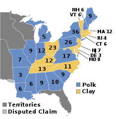
| 06:42, 28 בספטמבר 2009 |  | 593 × 577 (97 ק"ב) | Cg-realms | Previous version incorrectly awarded New York to Clay and granted Maryland 10 electoral votes. This version awards New York to Polk and grants Maryland only 8 votes, as per [http://www.nationalatlas.gov/printable/images/pdf/elections/elect04.pdf the Natio | |
| 06:41, 28 בספטמבר 2009 |  | 593 × 577 (97 ק"ב) | Cg-realms | Previous version incorrectly awarded New York to Clay and granted Maryland 10 electoral votes. This version awards New York to Polk and grants Maryland only 8 votes, as per [http://www.nationalatlas.gov/printable/images/pdf/elections/elect04.pdf the Natio | |
| 05:38, 25 בינואר 2009 |  | 593 × 577 (96 ק"ב) | Cg-realms | More accurate, stylistically consistent version | |
| 23:01, 31 בדצמבר 2008 |  | 593 × 1,020 (88 ק"ב) | AndyHogan14 | {{Information |Description={{en|1=1844 Electoral College}} |Source=Own work |Author=AndyHogan14 |Date= |Permission= |other_versions= }} <!--{{ImageUpload|full}}--> |
שימוש בקובץ
הדפים הבאים משתמשים בקובץ הזה:
שימוש גלובלי בקובץ
אתרי הוויקי השונים הבאים משתמשים בקובץ זה:
- שימוש באתר da.wikipedia.org
- שימוש באתר de.wikipedia.org
- שימוש באתר el.wikipedia.org
- שימוש באתר en.wikipedia.org
- 1844 United States presidential election
- Henry Clay
- Electoral vote changes between United States presidential elections
- List of United States presidential election results by state
- Presidency of John Tyler
- United States presidential election
- 1844 United States presidential election in Pennsylvania
- 1844 United States presidential election in Alabama
- 1844 United States presidential election in Arkansas
- 1844 United States presidential election in Connecticut
- 1844 United States presidential election in Delaware
- 1844 United States presidential election in Georgia
- 1844 United States presidential election in Illinois
- 1844 United States presidential election in Indiana
- 1844 United States presidential election in Kentucky
- 1844 United States presidential election in Louisiana
- 1844 United States presidential election in Maine
- 1844 United States presidential election in Maryland
- 1844 United States presidential election in Massachusetts
- 1844 United States presidential election in Michigan
- 1844 United States presidential election in Mississippi
- 1844 United States presidential election in Missouri
- 1844 United States presidential election in New Hampshire
- 1844 United States presidential election in New Jersey
- 1844 United States presidential election in New York
- 1844 United States presidential election in North Carolina
- 1844 United States presidential election in Ohio
- 1844 United States presidential election in Rhode Island
- 1844 United States presidential election in South Carolina
- 1844 United States presidential election in Tennessee
- 1844 United States presidential election in Vermont
- 1844 United States presidential election in Virginia
- Template:State results of the 1844 U.S. presidential election
- 1844 United States elections
- Template:1844 United States presidential election imagemap
- User:ChaosCron/sandbox
- History of the United States Whig Party
- User:DukeOfDelTaco/U.S. Presidential Elections
- שימוש באתר es.wikipedia.org
- שימוש באתר fi.wikipedia.org
- שימוש באתר fr.wikipedia.org
- שימוש באתר it.wikipedia.org
- שימוש באתר ja.wikipedia.org
- שימוש באתר ko.wikipedia.org